Brewhemia
Brewhemia is a bar in Edinburgh, Scotland which is located on Market Street. Brewhemia is situated nearby to the movie theater Scotsman Picturehouse, as well as near The Scotsman Hotel.| Tap on a place to explore it |
- Type: Bar
- Address: 1A Market Street, Edinburgh, EH1 1DE
- Wheelchair access: limited
Places of Interest Nearby
Highlights include Edinburgh Waverley Railway Station and Edinburgh Castle.
Edinburgh Waverley Railway Station
Railway station

Photo: 瑞丽江的河水, CC BY-SA 4.0.
Edinburgh Waverley is the principal railway station serving Edinburgh, Scotland. It is the second busiest station in Scotland, after Glasgow Central. The station serves as the northern terminus of the East Coast Main Line, 393 miles 13 chains from London King's Cross, although some trains operated by London North Eastern Railway continue to other Scottish destinations beyond Edinburgh. Edinburgh Waverley Railway Station is situated 440 feet northwest of Brewhemia.
Edinburgh Castle
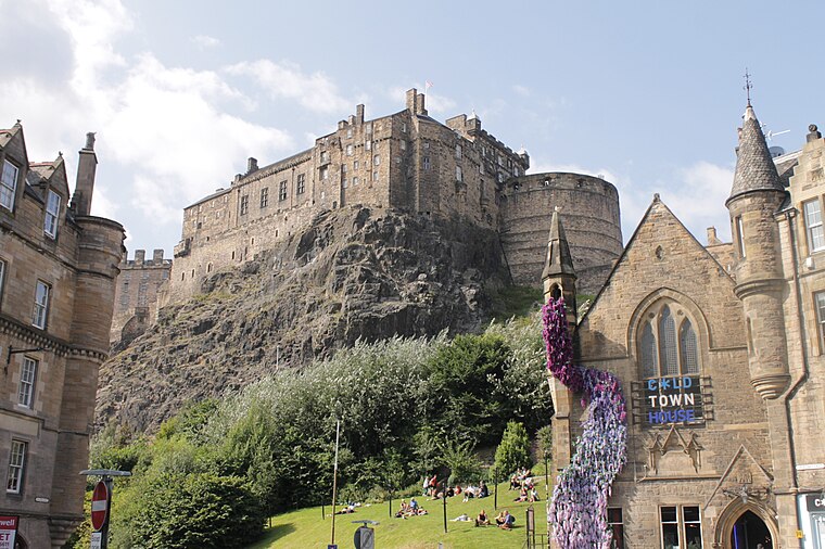
Photo: Stephencdickson, CC BY-SA 4.0.
Edinburgh Castle is a historic castle in Edinburgh, Scotland. It stands on Castle Rock, which has been occupied by humans since at least the Iron Age. There has been a royal castle on the rock since the reign of Malcolm III in the 11th century, and the castle continued to be a royal residence until 1633. Edinburgh Castle is situated 2,500 feet west of Brewhemia.
National Library of Scotland
Library

Photo: Marcok, CC BY-SA 4.0.
The National Library of Scotland is one of Scotland's National Collections. It is one of the largest libraries in the United Kingdom. As well as a public programme of exhibitions, events, workshops, and tours, the National Library of Scotland has reading rooms where visitors can access the collections. National Library of Scotland is situated 1,100 feet southwest of Brewhemia.
Places in the Area
Nearby places include Old Town and Dumbiedykes.
Old Town

Photo: PerryPlanet, CC BY-SA 3.0.
Old Town is the original settlement of Edinburgh. At its core is the Royal Mile, the long street descending east from Castle Crag to Holyrood Palace. This medieval city was cramped for space so it built higher and higher, and stank higher still, hence its nickname of "Auld Reekie".
Dumbiedykes
Suburb

Photo: Kim Traynor, CC BY-SA 3.0.
Dumbiedykes is a residential area in the centre of Edinburgh, Scotland. It mainly comprises public housing developments. It is bounded in the north by Holyrood Road, the west by the Pleasance and St Leonard's Street and the east by Holyrood Park.
New Town

Photo: AlasdairW, CC BY-SA 3.0.
New Town of Edinburgh is 250 years old, in contrast to the Old Town settled for over a thousand years. It was laid out on a grid pattern in the late 18th century with elegant Georgian townhouses, and the intervening loch was drained to become Princes Street Gardens.
Brewhemia
Latitude
55.95115° or 55° 57′ 4″ northLongitude
-3.18875° or 3° 11′ 20″ westOpen location code
9C7RXR26+FGOpenStreetMap ID
node 2858902357OpenStreetMap feature
amenity=barOpenStreetMap attribute
wheelchair=limited
This page is based on OpenStreetMap, Wikidata, and Wikimedia Commons.
We’d love your help improving our open data sources. Thank you for contributing.
Satellite Map
Discover Brewhemia from above in high-definition satellite imagery.
Notable Places Nearby
Highlights include Scotsman Picturehouse and The Scotsman Hotel.
Nearby Places
Explore places such as Mimi’s Little Bakehouse and The Halfway House.
Edinburgh: Must-Visit Destinations
Delve into Old Town, New Town, West Edinburgh, and Leith.
Curious Bars to Discover
Uncover intriguing bars from every corner of the globe.
About Mapcarta. Data © OpenStreetMap contributors and available under the Open Database License". Text is available under the CC BY-SA 4.0 license, except for photos, directions, and the map. Photo: Wikimedia, CC BY 3.0.