Tillingbourne
Tillingbourne is a building in Wotton, Mole Valley, England. Tillingbourne is situated nearby to the forest Sylvanus Wood, as well as near Damphurst Wood.| Tap on a place to explore it |
Places of Interest Nearby
Highlights include Church of St John the Evangelist and Wotton House.
Church of St John the Evangelist
Church

Photo: Colin Smith, CC BY-SA 2.0.
Church of St John the Evangelist is situated 4,000 feet northwest of Tillingbourne.
Wotton House
Hotel
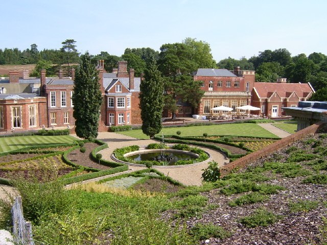
Photo: Barry Pearce, CC BY-SA 2.0.
Wotton House is a hotel, wedding venue, conference centre and former country house in Wotton near Dorking, Surrey, England. Originally the centre of the Wotton Estate and the seat of the Evelyn family, it was the birthplace in 1620 of diarist and landscape gardener John Evelyn, who built the first Italian garden in England there. Wotton House is situated 3,600 feet west of Tillingbourne.
Goddards
Manor estate

Photo: stevecadman, CC BY-SA 2.0.
Goddards is a Grade II*-listed house in Abinger Common, Surrey, England, completed in 1900. It was designed by Edwin Lutyens in the ideals of the Arts and Crafts movement and the west-facing courtyard garden was designed by Gertrude Jekyll. Goddards is situated 1¼ miles southwest of Tillingbourne.
Places in the Area
Nearby places include Friday Street and Westcott.
Friday Street
Hamlet

Photo: Richard Slessor, CC BY-SA 2.0.
Friday Street is a hamlet on the gentle lower north slope of Leith Hill in Surrey, England. It is in a wooded headwater ravine, just to the south of Wotton and the A25, a single rather than dual carriageway road, running between Guildford to the west and Dorking to the east.
Westcott
Village

Photo: Colin Smith, CC BY-SA 2.0.
Westcott is a village in central Surrey, England, about 1.5 miles west of the centre of Dorking. It is in the Mole Valley district and the Surrey Hills Area of Outstanding Natural Beauty.
Sutton Abinger
Hamlet

Photo: Colin Smith, CC BY-SA 2.0.
Abinger is a large, well-wooded and mostly rural civil parish that lies between the settlements of Dorking, Shere and Ewhurst in the district of Mole Valley, Surrey, England. Sutton Abinger is situated 2 miles west of Tillingbourne.
Tillingbourne
- Type: Building
- Location: Wotton, Mole Valley, Surrey, South East England, England, United Kingdom, Britain and Ireland, Europe
- View on OpenStreetMap
Latitude
51.2105° or 51° 12′ 38″ northLongitude
-0.38018° or 0° 22′ 49″ westOpen location code
9C3X6J69+5WOpenStreetMap ID
node 298136055OpenStreetMap feature
building=yes
This page is based on OpenStreetMap, Wikidata, and Wikimedia Commons.
We’d love your help improving our open data sources. Thank you for contributing.
Satellite Map
Discover Tillingbourne from above in high-definition satellite imagery.
Places with the Same Name
Discover other places named “Tillingbourne”.
Notable Places Nearby
Highlights include Sylvanus Wood and Damphurst Wood.
Nearby Places
Explore places such as Coast Hill Farm and Logmore Farm.
Surrey: Must-Visit Destinations
Delve into Guildford, Woking, Godalming, and Epsom.
Curious Buildings to Discover
Uncover intriguing buildings from every corner of the globe.
About Mapcarta. Data © OpenStreetMap contributors and available under the Open Database License". Text is available under the CC BY-SA 4.0 license, except for photos, directions, and the map. Photo: Wikimedia, CC0.