Easirent Edinburgh
Easirent Edinburgh is a car rental agency in Edinburgh, Scotland which is located on McDonald Place. Easirent Edinburgh is situated nearby to the military installation Army Reserve Centre, as well as near the fire station McDonald Road Community Fire & Ambulance Station.| Tap on a place to explore it |
- Type: Car rental agency
- Also known as: “Edinburgh Motor Company”
- Address: 21 McDonald Place, Edinburgh, EH7 4NH
Places of Interest Nearby
Highlights include Edinburgh Castle and McDonald Road Library.
Edinburgh Castle
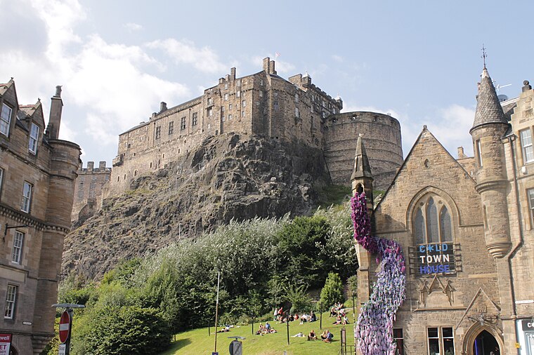
Photo: Stephencdickson, CC BY-SA 4.0.
Edinburgh Castle is a historic castle in Edinburgh, Scotland. It stands on Castle Rock, which has been occupied by humans since at least the Iron Age. There has been a royal castle on the rock since the reign of Malcolm III in the 11th century, and the castle continued to be a royal residence until 1633. Edinburgh Castle is situated 1¼ miles southwest of Easirent Edinburgh.
McDonald Road Library
Library

Photo: Brian McNeil, CC BY 3.0.
McDonald Road Library is one of 28 freely-accessible public libraries in Edinburgh, Scotland. The library opened in 1904 as the East Branch of the city's library service. McDonald Road Library is situated 1,200 feet southeast of Easirent Edinburgh.
Calton Hill
Park

Photo: 瑞丽江的河水, CC BY-SA 4.0.
Calton Hill is a hill in central Edinburgh, Scotland, situated beyond the east end of Princes Street and included in the city's UNESCO World Heritage Site. Calton Hill is situated 3,100 feet south of Easirent Edinburgh.
Places in the Area
Nearby places include Broughton and Pilrig.
Broughton
Suburb

Photo: Kim Traynor, CC BY-SA 3.0.
Broughton is an area of Edinburgh, Scotland. Broughton was an ancient feudal barony that existed outside of Edinburgh before it was later incorporated into the city as urban development took place in the 18th and 19th centuries.
Pilrig
Quarter

Photo: Kim Traynor, CC BY-SA 3.0.
Pilrig is an area of Edinburgh, the capital of Scotland. The name probably derives from the long field on which a peel tower stood. There is evidence of a peel tower situated on an area of higher ground above the Water of Leith.
Powderhall
Neighborhood

Photo: kim traynor, CC BY-SA 2.0.
Powderhall is an area lying between Broughton Road and Warriston Road in the north of Edinburgh, the Scottish capital. Until recently it was best known for Powderhall Stadium, a greyhound racing track, which has now closed.
Easirent Edinburgh
- Category: transportation
- Location: Edinburgh, Scotland, United Kingdom, Britain and Ireland, Europe
- View on OpenStreetMap
Latitude
55.96358° or 55° 57′ 49″ northLongitude
-3.18593° or 3° 11′ 9″ westOpen location code
9C7RXR77+CJOpenStreetMap ID
node 3215553818OpenStreetMap feature
amenity=car_rental
This page is based on OpenStreetMap, Wikidata, and Wikimedia Commons.
We’d love your help improving our open data sources. Thank you for contributing.
Satellite Map
Discover Easirent Edinburgh from above in high-definition satellite imagery.
Notable Places Nearby
Highlights include Army Reserve Centre and McDonald Road Community Fire & Ambulance Station.
Nearby Places
Explore places such as Bellevue Apartments and Hopetoun Street.
Edinburgh: Must-Visit Destinations
Delve into Old Town, New Town, West Edinburgh, and Leith.
Curious Car Rental Agencies to Discover
Uncover intriguing car rental agencies from every corner of the globe.
About Mapcarta. Data © OpenStreetMap contributors and available under the Open Database License". Text is available under the CC BY-SA 4.0 license, except for photos, directions, and the map. Photo: Wikimedia, CC BY 3.0.