De Marinier
De Marinier is a work of art in Baarn Municipality, Utrecht. De Marinier is situated nearby to Baarn railway station, as well as near the grassland Amalia-park.| Tap on a place to explore it |
- Type: Work of art
- Artwork type: statue
- Description: war memorial in Baarn, Netherlands
Places of Interest Nearby
Highlights include Baarn railway station and Paaskerk.
Baarn railway station
Railway station
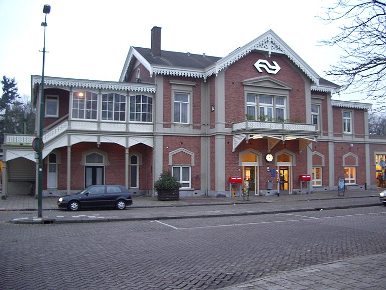
Photo: T Houdijk, CC BY-SA 3.0.
Baarn is a railway station on the Amsterdam–Zutphen railway and the Den Dolder–Baarn railway located in Baarn, Netherlands. The station is operated by the Nederlandse Spoorwegen. Baarn railway station is situated 260 metres southeast of De Marinier.
Paaskerk
Church

Photo: Atsje, CC BY-SA 3.0.
Paaskerk is a church, which is situated 340 metres northeast of De Marinier.
Soestdijk Palace
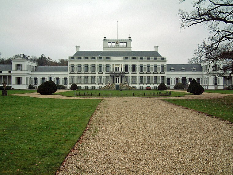
Photo: Bouke, CC BY-SA 3.0.
Soestdijk Palace is a palace formerly belonging to the Dutch royal family. It consists of a central block and two wings. Although named after the village of Soestdijk, which is largely in the municipality of Soest, Soestdijk Palace is just north of the border in the municipality of Baarn in the province of Utrecht. Soestdijk Palace is situated 2 km south of De Marinier.
Places in the Area
Nearby places include Soestdijk and Eembrugge.
Soestdijk
Neighborhood

Photo: Wikimedia, CC BY-SA 4.0.
Soestdijk is a neighbourhood of Soest and a hamlet in the municipality of Baarn. Both are part of the province of Utrecht, Netherlands. The village gives its name to Paleis Soestdijk, which from 1937 to 2004 was the residence of Princess and later Queen Juliana and Prince Bernhard. Soestdijk is situated 2½ km south of De Marinier.
Eembrugge
Hamlet

Photo: Milliped, CC BY-SA 4.0.
Eembrugge is a hamlet and former city on the river Eem, east of Baarn, in the Netherlands. It received city rights between 1336 en 1340, but was destroyed in 1527. Eembrugge is partially in the municipality of Eemnes, partially in Baarn. Eembrugge is situated 3 km northeast of De Marinier.
Soest

Photo: WeeJeeVee, CC BY-SA 3.0 nl.
Soest is a medium sized city in the Dutch province of Utrecht. It's known as a major base for the Dutch army, which uses large parts of forests and heathlands of the surrounding Soesterduinen and Soesterberg as training grounds.
De Marinier
- Categories: sculpture, war memorial, tourism, historic site, and memorial
- Location: Baarn Municipality, Utrecht, Western Netherlands, Netherlands, Benelux, Europe
- View on OpenStreetMap
Latitude
52.20937° or 52° 12′ 34″ northLongitude
5.2786° or 5° 16′ 43″ eastOpen location code
9F47675H+PCOpenStreetMap ID
node 4197064889OpenStreetMap feature
historic=memorialOpenStreetMap feature
tourism=artworkOpenStreetMap attribute
artwork_type=statueWikidata ID
Q4722085
This page is based on OpenStreetMap, Wikidata, and Wikimedia Commons.
We’d love your help improving our open data sources. Thank you for contributing.
Satellite Map
Discover De Marinier from above in high-definition satellite imagery.
In Other Languages
“De Marinier” goes by many names.
- Dutch: “‘De Marinier’”
- Dutch: “De Marinier”
Notable Places Nearby
Highlights include Amalia-park and Bevrijdingsmonument Baarn.
Nearby Places
Explore places such as INNAX and Bitonic B.V..
Utrecht: Must-Visit Destinations
Delve into Utrecht, Amersfoort, Zeist, and Veenendaal.
Curious Work Of Arts to Discover
Uncover intriguing work of arts from every corner of the globe.
About Mapcarta. Data © OpenStreetMap contributors and available under the Open Database License". Text is available under the CC BY-SA 4.0 license, except for photos, directions, and the map. Photo: Sterkebak, CC BY 2.5.