Soest
Soest is a medium sized city in the Dutch province of Utrecht. It's known as a major base for the Dutch army, which uses large parts of forests and heathlands of the surrounding Soesterduinen and Soesterberg as training grounds.| Tap on a place to explore it |
Photo: Rob Kemme, CC BY-SA 2.0.
Photo: WeeJeeVee, CC BY-SA 3.0 nl.
- Type: Town with 39,400 residents
- Description: municipality in the Netherlands
- Also known as: “Soest Municipality” and “Soest, Netherlands”
- Neighbors: Amersfoort and Zeist
Places of Interest
Highlights include Soestdijk Palace and Enghenbergje.
Soestdijk Palace
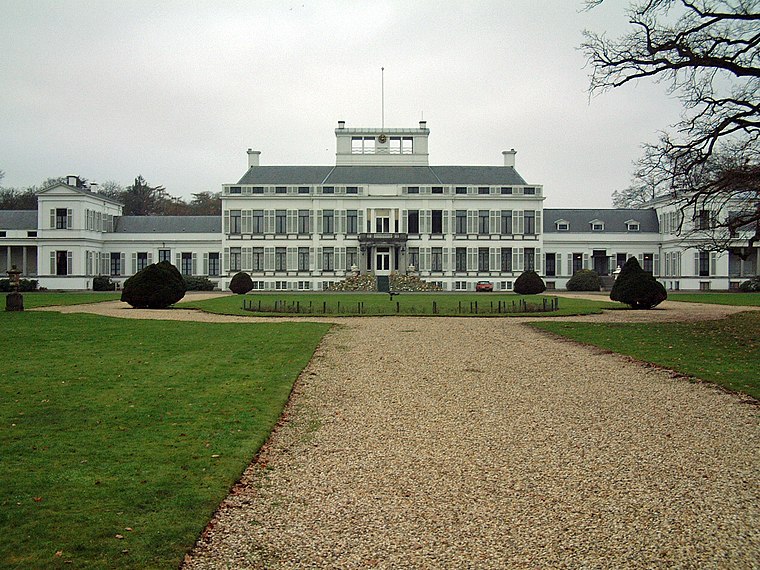
Photo: Bouke, CC BY-SA 3.0.
Soestdijk Palace is a palace formerly belonging to the Dutch royal family. It consists of a central block and two wings. Although named after the village of Soestdijk, which is largely in the municipality of Soest, Soestdijk Palace is just north of the border in the municipality of Baarn in the province of Utrecht.
Enghenbergje
Archaeological site

Photo: Swarte Kees, Public domain.
Enghenbergje is an archaeological site.
Soestdijk railway station
Railway station

Photo: T Houdijk, CC BY-SA 4.0.
Soestdijk is a railway station located in Soestdijk, Netherlands. The station was opened on 27 June 1898 on the single track Den Dolder–Baarn railway.
Places in the Area
Nearby places include Baarn Municipality and Soestdijk.
Baarn Municipality
Town
 Baarn is a municipality and a town in the Netherlands, near Hilversum in the province of Utrecht. Baarn Municipality is situated 4 km north of Soest.
Soestdijk
Neighborhood

Photo: Wikimedia, CC BY-SA 4.0.
Soestdijk is a neighbourhood of Soest and a hamlet in the municipality of Baarn. Both are part of the province of Utrecht, Netherlands. The village gives its name to Paleis Soestdijk, which from 1937 to 2004 was the residence of Princess and later Queen Juliana and Prince Bernhard.
Hoogland
Village
Hoogland is a village and former free-standing municipality in the province of Utrecht in the Netherlands. It is located north of the Amersfoort city centre. Hoogland is situated 6 km east of Soest.
Soest
- Categories: municipality of the Netherlands and locality
- Location: Utrecht, Western Netherlands, Netherlands, Benelux, Europe
- View on OpenStreetMap
Latitude
52.1746° or 52° 10′ 29″ northLongitude
5.291° or 5° 17′ 28″ eastPopulation
39,400Elevation
14 metres (46 feet)Open location code
9F4757FR+R9OpenStreetMap ID
node 45568761OpenStreetMap feature
place=townGeoNames ID
2747033Wikidata ID
Q10041
This page is based on OpenStreetMap, GeoNames, Wikidata, Wikimedia Commons, and Wikivoyage.
We’d love your help improving our open data sources. Thank you for contributing.
Satellite Map
Discover Soest from above in high-definition satellite imagery.
In Other Languages
From Afrikaans to Zeeuws—“Soest” goes by many names.
- Afrikaans: “Soest, Nederland”
- Afrikaans: “Soest”
- Albanian: “Soest (Holandë)”
- Albanian: “Soest”
- Arabic: “سوست”
- Armenian: “Սուստ”
- Asturian: “Soest”
- Azerbaijani: “Sust”
- Balinese: “Soest (Belanda)”
- Balinese: “Soest”
- Basque: “Soest”
- Belarusian: “Суст”
- Catalan: “Soest”
- Cebuano: “Gemeente Soest”
- Chinese: “苏斯特”
- Chinese: “蘇斯特”
- Czech: “Soest”
- Danish: “Soest”
- Dutch: “gemeente Soest”
- Dutch: “Gemeente Soest”
- Dutch: “Soest (gemeente)”
- Dutch: “Soest (Nederland)”
- Dutch: “Soest”
- Esperanto: “Soest”
- French: “Soest”
- German: “Soest”
- Hebrew: “סוסט”
- Hungarian: “Soest”
- Indonesian: “Soest”
- Irish: “Soest”
- Italian: “Soest”
- Japanese: “ススト”
- Korean: “수스트”
- Kurdish: “Soest, Utrecht”
- Kurdish: “Soest”
- Limburgan: “Soest”
- Lithuanian: “Zostas”
- Low German: “Soest”
- Luxembourgish: “Soest”
- Macedonian: “Суст”
- Malay: “Soest”
- Norwegian Bokmål: “Soest”
- Norwegian: “Soest”
- Occitan (post 1500): “Soest”
- Persian: “سوست”
- Polish: “Soest”
- Portuguese: “Soest”
- Romanian: “Soest”
- Russian: “Суст”
- Saterfriesisch: “Soest”
- Spanish: “Soest”
- Swedish: “Soest, Nederländerna”
- Swedish: “Soest”
- Turkish: “Soest, Hollanda”
- Turkish: “Soest”
- Ukrainian: “Суст”
- Urdu: “سوست، نیدرلینڈز”
- Venetian: “Soest (Paexi Basi)”
- Venetian: “Soest”
- Volapük: “Soest”
- Waray (Philippines): “Soest, Nederlandes”
- Waray (Philippines): “Soest”
- Welsh: “Soest”
- Western Frisian: “Soest”
- Zeeuws: “Soest”
Places with the Same Name
Discover other places named “Soest”.
Localities in the Area
Explore places such as De Eng Noord West and Klaarwater.
Utrecht: Must-Visit Destinations
Delve into Utrecht, Amersfoort, Zeist, and Veenendaal.
Explore These Curated Destinations
Discover places selected for their distinct character and enduring appeal.
About Mapcarta. Data © OpenStreetMap contributors and available under the Open Database License". Text is available under the CC BY-SA 4.0 license, except for photos, directions, and the map. Description text is based on the Wikivoyage page “Soest”. Photo: WeeJeeVee, CC BY-SA 3.0 nl.