Fat Jackets
Fat Jackets is a fast food restaurant in England, United Kingdom which is located on The Quays. Fat Jackets is situated nearby to The Lowry Mall Post Office, as well as near the movie theater Vue.| Tap on a place to explore it |
Places of Interest Nearby
Highlights include Old Trafford and Imperial War Museum North.
Old Trafford
Stadium
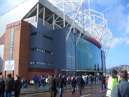
Photo: Wikimedia, Public domain.
Old Trafford is a football stadium in Old Trafford, Greater Manchester, England, and is the home of Manchester United. With a capacity of 74,197, it is the largest club football stadium in the United Kingdom, and the eleventh-largest in Europe. Old Trafford is situated 3,000 feet south of Fat Jackets.
Imperial War Museum North
Museum
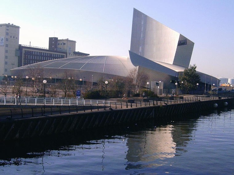
Photo: pit-yacker, CC BY-SA 2.0.
Imperial War Museum North is a museum in the Metropolitan Borough of Trafford in Greater Manchester, England. One of five branches of the Imperial War Museum, it explores the impact of modern conflicts on people and society. Imperial War Museum North is situated 1,600 feet southwest of Fat Jackets.
The Lowry
Art gallery

Photo: Whittlepedia, CC BY-SA 3.0.
Lowry is a theatre and gallery complex at Salford Quays, Salford, Greater Manchester, England. It is named after the early 20th-century painter L. S. Lowry, known for his paintings of industrial scenes in North West England. The Lowry is situated 870 feet west of Fat Jackets.
Places in the Area
Nearby places include Salford Quays and The Quays.
Salford Quays
Suburb

Photo: Frombowen, CC BY-SA 4.0.
Salford Quays is an area of Salford, Greater Manchester, England, near the end of the Manchester Ship Canal. Previously the site of Manchester Docks, it faces Trafford across the canal.
The Quays
 The Quays covers the four areas of Salford Quays, Trafford Wharf, Old Trafford and Trafford Centre to the west of Manchester city centre.
MediaCityUK
Neighborhood

Photo: Briangeorge1945, CC BY-SA 4.0.
MediaCityUK is a 200-acre mixed-use property development on the banks of the Manchester Ship Canal in Salford, Greater Manchester, England. The project was developed by Peel Media; its principal tenants are media organisations and the Quayside MediaCityUK shopping centre.
Fat Jackets
- Type: Fast food restaurant
- Address: F8b The Quays, Salford, M50 3AH
- Categories: food and restaurant
- Location: England, United Kingdom, Britain and Ireland, Europe
- View on OpenStreetMap
Latitude
53.47134° or 53° 28′ 17″ northLongitude
-2.29219° or 2° 17′ 32″ westOpen location code
9C5VFPC5+G4OpenStreetMap ID
node 4310498040OpenStreetMap feature
amenity=fast_food
This page is based on OpenStreetMap, Wikidata, and Wikimedia Commons.
We’d love your help improving our open data sources. Thank you for contributing.
Satellite Map
Discover Fat Jackets from above in high-definition satellite imagery.
Notable Places Nearby
Highlights include The Lowry Mall Post Office and Vue.
Nearby Places
Explore places such as Subway and Harry Ramsden’s express.
England: Must-Visit Destinations
Delve into London, Manchester, Sheffield, and Leeds.
Curious Fast Food Restaurants to Discover
Uncover intriguing fast food restaurants from every corner of the globe.
About Mapcarta. Data © OpenStreetMap contributors and available under the Open Database License". Text is available under the CC BY-SA 4.0 license, except for photos, directions, and the map. Photo: sidibousaid, CC BY 2.0.