San Bartolomeo, Rimini
San Bartolomeo, also known as the Santi Bartolomeo e Marino or Santa Rita, is a Baroque-style Roman Catholic church located in Rimini, region of Emilia-Romagna, Italy.| Tap on a place to explore it |
- Type: Church
- Denomination: Catholic
- Description: Roman Catholic church in Rimini, Italy
- Also known as: “Santi Bartolomeo e Marino (Santa Rita)”
- Wheelchair access: no
Places of Interest Nearby
Highlights include Tempio Malatestiano and Arch of Augustus.
Tempio Malatestiano
Church

Photo: Sailko, CC BY-SA 3.0.
The Tempio Malatestiano is the unfinished cathedral church of Rimini, Italy. Officially named for St. Francis, it takes the popular name from Sigismondo Pandolfo Malatesta, who commissioned its reconstruction by the famous Renaissance theorist and architect Leon Battista Alberti around 1450. Tempio Malatestiano is situated 270 metres northwest of San Bartolomeo, Rimini.
Arch of Augustus
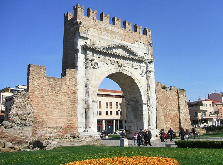
Photo: Il Malatestiano, CC BY-SA 4.0.
The Arch of Augustus is a gate set in the former city wall of Rimini, Emilia-Romagna, in the form of an ancient Roman triumphal arch. Built in 27 BC in honour of Augustus, the first Roman emperor, the arch marks the northern end of the Via Flaminia, the road between Ariminum and Rome constructed in 220 BC by Gaius Flaminius. Arch of Augustus is situated 260 metres southwest of San Bartolomeo, Rimini.

Places in the Area
Nearby places include Rivazzurra and Viserba.
Rivazzurra
Neighborhood
 Rivazzurra is a neighborhood, which is situated 4 km southeast of San Bartolomeo, Rimini.
Viserba
Village

Photo: Albertomos, Public domain.
Viserba is a village, which is situated 4½ km northwest of San Bartolomeo, Rimini.
Miramare di Rimini
Neighborhood

Photo: trolvag, CC BY-SA 3.0.
Miramare di Rimini, more commonly known simply as Miramare, is the southernmost suburb and frazione of the city of Rimini, Italy. Situated on the Adriatic coast, the seaside resort lies 5 km southeast of Rimini's city centre and borders the municipality of Riccione. Miramare di Rimini is situated 5 km southeast of San Bartolomeo, Rimini.
San Bartolomeo, Rimini
- Categories: geographic location, place of worship, and religion
- Location: Rimini, Rimini, Emilia-Romagna, Northeast Italy, Italy, Europe
- View on OpenStreetMap
Latitude
44.05858° or 44° 3′ 31″ northLongitude
12.57337° or 12° 34′ 24″ eastOpen location code
8FPJ3H5F+C8OpenStreetMap ID
node 4377391364OpenStreetMap feature
amenity=place_of_worshipOpenStreetMap attribute
denomination=catholicOpenStreetMap attribute
wheelchair=noWikidata ID
Q25112975
This page is based on OpenStreetMap, Wikidata, Wikimedia Commons, and Wikipedia.
We’d love your help improving our open data sources. Thank you for contributing.
Satellite Map
Discover San Bartolomeo, Rimini from above in high-definition satellite imagery.
In Other Languages
“San Bartolomeo, Rimini” goes by many names.
- Italian: “Chiesa di San Bartolomeo”
Notable Places Nearby
Highlights include gym and Mini mix.
Nearby Places
Explore places such as Sartorıa Del Arte and Santa Rita.
Rimini: Must-Visit Destinations
Delve into Riccione, Pennabilli, and Novafeltria.
Curious Churches to Discover
Uncover intriguing churches from every corner of the globe.
About Mapcarta. Data © OpenStreetMap contributors and available under the Open Database License". Text is available under the CC BY-SA 4.0 license, except for photos, directions, and the map. Description text is based on the Wikipedia page “San Bartolomeo, Rimini”. Photo: Mister No, CC BY 3.0.