Station Soestdijk
Station Soestdijk is a bus stop in Soest, Utrecht. Station Soestdijk is situated nearby to Soestdijk railway station, as well as near the cemetery Begraafplaats Dalweg.| Tap on a place to explore it |
Places of Interest Nearby
Highlights include Soestdijk railway station and Soestdijk Palace.
Soestdijk railway station
Railway station

Photo: T Houdijk, CC BY-SA 4.0.
Soestdijk is a railway station located in Soestdijk, Netherlands. The station was opened on 27 June 1898 on the single track Den Dolder–Baarn railway.
Soestdijk Palace
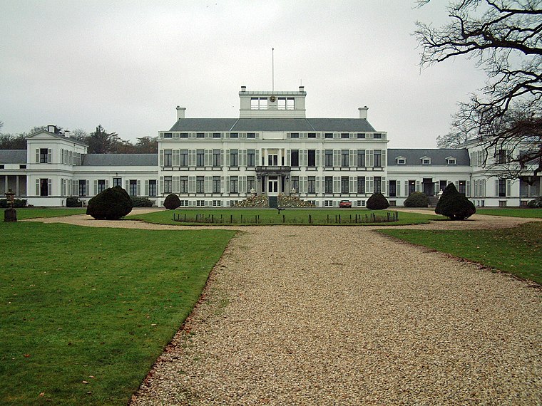
Photo: Bouke, CC BY-SA 3.0.
Soestdijk Palace is a palace formerly belonging to the Dutch royal family. It consists of a central block and two wings. Although named after the village of Soestdijk, which is largely in the municipality of Soest, Soestdijk Palace is just north of the border in the municipality of Baarn in the province of Utrecht. Soestdijk Palace is situated 1½ km northwest of Station Soestdijk.
Petrus en Pauluskerk, Soest
Church

Photo: Atsje, CC BY-SA 3.0.
Petrus en Pauluskerk, Soest is a church, which is situated 460 metres southeast of Station Soestdijk.
Places in the Area
Nearby places include Soestdijk and Baarn Municipality.
Soestdijk
Neighborhood

Photo: Wikimedia, CC BY-SA 4.0.
Soestdijk is a neighbourhood of Soest and a hamlet in the municipality of Baarn. Both are part of the province of Utrecht, Netherlands. The village gives its name to Paleis Soestdijk, which from 1937 to 2004 was the residence of Princess and later Queen Juliana and Prince Bernhard.
Baarn Municipality
Town
 Baarn is a municipality and a town in the Netherlands, near Hilversum in the province of Utrecht. Baarn Municipality is situated 3 km north of Station Soestdijk.
Soestduinen
Hamlet
Soestduinen is a hamlet in the Dutch province of Utrecht. It is a part of the municipality of Soest, and lies about 3 km south of Soest. The hamlet was first mentioned in 1936 as Soestduinen, and means the dunes near Soest. Soestduinen is situated 4½ km south of Station Soestdijk.
Station Soestdijk
- Type: Bus stop
- Categories: transport stop and transportation
- Location: Soest, Utrecht, Western Netherlands, Netherlands, Benelux, Europe
- View on OpenStreetMap
Latitude
52.1843° or 52° 11′ 4″ northLongitude
5.29983° or 5° 17′ 59″ eastOpen location code
9F4757MX+PWOpenStreetMap ID
node 4528991647OpenStreetMap feature
public_transport=stop_position
This page is based on OpenStreetMap, Wikidata, and Wikimedia Commons.
We’d love your help improving our open data sources. Thank you for contributing.
Satellite Map
Discover Station Soestdijk from above in high-definition satellite imagery.
Places with the Same Name
Discover other places named “Station Soestdijk”.
Notable Places Nearby
Highlights include Begraafplaats Dalweg and Poortgebouw, Soest.
Nearby Places
Explore places such as Station Soestdijk and Boutique des Fleurs.
Utrecht: Must-Visit Destinations
Delve into Utrecht, Amersfoort, Zeist, and Veenendaal.
Curious Bus Stops to Discover
Uncover intriguing bus stops from every corner of the globe.
About Mapcarta. Data © OpenStreetMap contributors and available under the Open Database License". Text is available under the CC BY-SA 4.0 license, except for photos, directions, and the map. Photo: WeeJeeVee, CC BY-SA 3.0 nl.