NCN Information Panel
NCN Information Panel is in Northern Ireland, United Kingdom. NCN Information Panel is situated nearby to the historic site Union Locks (former), as well as near Moore’s Bridge.| Tap on a place to explore it |
Places of Interest Nearby
Highlights include Lagan Valley Hospital and Lisnagarvey High School.
Lagan Valley Hospital
Hospital
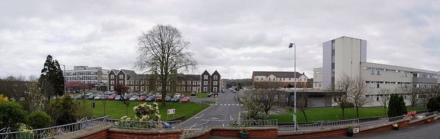
Photo: Swc1987, CC BY-SA 3.0.
The Lagan Valley Hospital is a hospital in Lisburn, County Antrim, Northern Ireland. It provides services to people from Greater Lisburn, the Lisburn City Council area and other parts of South East Ulster. Lagan Valley Hospital is situated 3,700 feet northeast of NCN Information Panel.
Lisnagarvey High School
School
Lisnagarvey High School is a controlled mixed secondary school located in Lisburn, County Antrim, Northern Ireland. It was established in 1957 and is within the South Eastern region of the Education Authority. Lisnagarvey High School is situated 2,800 feet north of NCN Information Panel.
Christ Church Cathedral, Lisburn
Church

Photo: JohnArmagh, CC BY-SA 3.0.
Christ Church Cathedral, Lisburn, is the cathedral church of the Diocese of Connor in the Church of Ireland. It is situated in Lisburn, Northern Ireland, in the ecclesiastical province of Armagh. Christ Church Cathedral, Lisburn is situated 1 mile northeast of NCN Information Panel.
Places in the Area
Nearby places include Lisburn and Tullynacross.
Lisburn

Photo: Ardfern, CC BY-SA 3.0.
Lisburn is a market town traditionally in County Antrim north of the River Lagan; a small part lies south of the river in County Down. The counties have been abolished in Northern Ireland so since 2015 it's been in the "super-district" of Lisburn and Castlereagh.
Tullynacross
Village
Tullynacross is a small village in Lisburn, County Antrim, Northern Ireland, near Lambeg. In the 2001 Census it had a population of 159 people. It lies within the civil parish of Lambeg, the barony of Castlereagh Upper, and is situated within the Lagan Valley Regional Park. Tullynacross is situated 2½ miles northeast of NCN Information Panel.
Hillsborough

Photo: Sitomon, CC BY-SA 2.0.
Hillsborough is a village historically in County Down in Northern Ireland, nowadays governed as part of Lisburn and Castlereagh District. It's an attractive Georgian village dominated by Hillsborough Castle, the official residence of the Secretary of State for Northern Ireland, and of the King whenever he's in the province.
NCN Information Panel
- Type: Sign
- Categories: information and tourism
- Location: Northern Ireland, United Kingdom, Britain and Ireland, Europe
- View on OpenStreetMap
Latitude
54.49746° or 54° 29′ 51″ northLongitude
-6.05615° or 6° 3′ 22″ westOperator
SustransOpen location code
9C6MFWWV+XGOpenStreetMap ID
node 4596426812OpenStreetMap feature
tourism=information
This page is based on OpenStreetMap, Wikidata, and Wikimedia Commons.
We’d love your help improving our open data sources. Thank you for contributing.
Satellite Map
Discover NCN Information Panel from above in high-definition satellite imagery.
Notable Places Nearby
Highlights include Union Locks (former) and Moore’s Bridge.
Nearby Places
Explore places such as Millennium Milepost and Premier Inn.
Northern Ireland: Must-Visit Destinations
Delve into Belfast, Derry, Giant’s Causeway, and Armagh.
Curious Places to Discover
Uncover intriguing places from every corner of the globe.
About Mapcarta. Data © OpenStreetMap contributors and available under the Open Database License". Text is available under the CC BY-SA 4.0 license, except for photos, directions, and the map. Photo: Chmee2, CC BY 3.0.