Olof Palme
Olof Palme is a monument in Mexico City, Central Mexico. Olof Palme is situated nearby to the church Parroquia del Santísimo Redentor, as well as near the community center Pilares Enrique Calderón Alzati.| Tap on a place to explore it |
Places of Interest Nearby
Highlights include Angel of Independence and Embassy of the United Kingdom.
Angel of Independence

Photo: Cvmontuy, CC BY-SA 4.0.
The Angel of Independence, most commonly known by the shortened name El Ángel and officially known as Monumento a la Independencia, is a victory column on a roundabout on the major thoroughfare of Paseo de la Reforma in downtown Mexico City. Angel of Independence is situated 790 metres south of Olof Palme.
Embassy of the United Kingdom
Government office

Photo: Aquintero82, CC BY-SA 4.0.
The British Embassy in Mexico City is the chief diplomatic mission of the United Kingdom in Mexico. The embassy is located on Paseo de la Reforma 350 20th Floor, Torre del Angel. Embassy of the United Kingdom is situated 590 metres southeast of Olof Palme.
National Museum of Anthropology
Museum
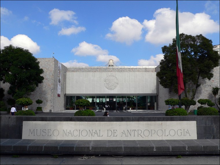
Photo: Wikimedia, CC BY-SA 3.0.
The National Museum of Anthropology is a national museum of Mexico. It is the largest and most visited museum in Mexico. Located in the area between Paseo de la Reforma and Mahatma Gandhi Street within Chapultepec Park in Mexico City, the museum contains… National Museum of Anthropology is situated 2 km southwest of Olof Palme.
Places in the Area
Nearby places include Zona Rosa and Little Seoul.
Zona Rosa

Photo: Virtual Raider, CC BY 2.0.
Zona Rosa is a business and entertainment district located in a portion of Colonia Juárez, near the center of Mexico City. It is one of the city's most touristy areas, filled with hotels, dance clubs, restaurants, bars and live bands.
Little Seoul
Neighborhood
Pequeño Seúl is a Koreatown in Mexico City. Most of the city's Korean population lives in and around the Zona Rosa. According to the newspaper Reforma, there are at least 5,000 Koreans living in Zona Rosa and about 6,000 total in Colonia Juárez, the larger officially recognized neighborhood of which the Zona Rosa is a part of.
Colonia Juárez
Neighborhood

Photo: Thelmadatter, Public domain.
Colonia Juárez is one of the better-known neighborhoods or colonias in the Cuauhtémoc borough of Mexico City. The neighborhood is shaped like a long triangle with the boundaries: Paseo de la Reforma on the north, Avenida Chapultepec on the south, and Eje 1 Poniente on the east.
Olof Palme
- Type: Monument
- Category: historic site
- Location: Mexico City, Central Mexico, Mexico, North America
- View on OpenStreetMap
Latitude
19.43381° or 19° 26′ 2″ northLongitude
-99.17° or 99° 10′ 12″ westOpen location code
76F2CRMJ+G2OpenStreetMap ID
node 4728078546OpenStreetMap feature
historic=monument
This page is based on OpenStreetMap, Wikidata, and Wikimedia Commons.
We’d love your help improving our open data sources. Thank you for contributing.
Satellite Map
Discover Olof Palme from above in high-definition satellite imagery.
Places with the Same Name
Discover other places named “Olof Palme”.
Notable Places Nearby
Highlights include Parque Olof Palme and Parroquia del Santísimo Redentor.
Nearby Places
Explore places such as Farmacia Cuauhtémoc and Oxxo.
Mexico City: Must-Visit Destinations
Delve into Centro, Xochimilco, Coyoacán, and Condesa and Roma.
Curious Monuments to Discover
Uncover intriguing monuments from every corner of the globe.
About Mapcarta. Data © OpenStreetMap contributors and available under the Open Database License". Text is available under the CC BY-SA 4.0 license, except for photos, directions, and the map. Photo: Wikimedia, CC BY 2.0.