Path Quebrada San Francisco
Path Quebrada San Francisco is in Candelaria, Bogotá D.C., Bogotá, and is located on Carrera 1. Path Quebrada San Francisco is situated nearby to the spring Chorro de Padilla, as well as near Molino El Boqueron.| Tap on a place to explore it |
- Opening hours: Saturday—Sunday 6:00 AM—10:00 AM
- Type: Tourist attraction
- Also known as: “Sendero Quebrada San Francisco”
- Address: Carrera 1
Places of Interest Nearby
Highlights include Monserrate and Gold Museum.
Monserrate
Peak

Photo: Pedro Felipe, CC BY-SA 4.0.
Monserrate is a mountain over 3,000 metres high that overlooks the city center of Bogotá, the capital city of Colombia. It rises to 3,152 meters above the sea level, where there is a church with a shrine, devoted to El Señor Caído.
Gold Museum
Museum
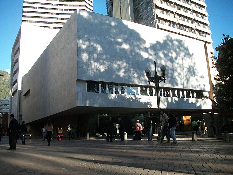
Photo: Pedro Felipe, CC BY-SA 3.0.
The Museum of Gold is an archaeology museum located in Bogotá, Colombia. It is one of the most visited touristic highlights in the country. The museum receives around 500,000 tourists per year. Gold Museum is situated 1½ km west of Path Quebrada San Francisco.
Monserrate Sanctuary
Church

Photo: Pedro Felipe, CC BY-SA 4.0.
Monserrate Sanctuary is a Catholic shrine in Bogotá, Colombia. The sanctuary was built between 1650 and 1657 and is 3,152 metres above sea level. Monserrate Sanctuary is situated 640 metres northeast of Path Quebrada San Francisco.
Places in the Area
Nearby places include Santa Fe and La Candelaria.
Santa Fe
Suburb

Photo: Baiji, CC BY-SA 3.0.
Santa Fe is the third locality of Bogotá, the Capital District of Colombia. Santa Fe is part of the traditional downtown area where Bogotá was founded by Gonzalo Jiménez de Quesada on August 6, 1538.
La Candelaria
 La Candelaria is the historic center of Bogotá, and the city's principal destination for tourists. Home to the top museums, the government palaces, and beautiful old colonial buildings along narrow cobblestone streets, it's a must see.
Laches
Neighborhood
Laches is a neighbourhood of Bogotá, Colombia. It is in the Santa Fe district in east-central Bogotá, on the edge of the forest reserve. Historically, the population was very poor, and continued to be so well into the twenty-first century.
Path Quebrada San Francisco
- Category: tourism
- Location: Candelaria, Bogotá D.C., Bogotá, Andino, Colombia, South America
- View on OpenStreetMap
Latitude
4.60114° or 4° 36′ 4″ northLongitude
-74.0591° or 74° 3′ 33″ westOpen location code
67P7JW2R+F9OpenStreetMap ID
node 4833521621OpenStreetMap feature
tourism=attraction
This page is based on OpenStreetMap, Wikidata, and Wikimedia Commons.
We’d love your help improving our open data sources. Thank you for contributing.
Satellite Map
Discover Path Quebrada San Francisco from above in high-definition satellite imagery.
Notable Places Nearby
Highlights include Chorro de Padilla and Molino El Boqueron.
Nearby Places
Explore places such as Centro las Gaviotas and 509 Centro las Gaviotas.
Bogotá: Must-Visit Destinations
Delve into La Candelaria, Zona Rosa, Santa Fé-Los Mártires, and Usaquén.
Curious Places to Discover
Uncover intriguing places from every corner of the globe.
About Mapcarta. Data © OpenStreetMap contributors and available under the Open Database License". Text is available under the CC BY-SA 4.0 license, except for photos, directions, and the map. Photo: Wikimedia, CC BY-SA 3.0.