La Candelaria
La Candelaria is the historic center of Bogotá, and the city's principal destination for tourists. Home to the top museums, the government palaces, and beautiful old colonial buildings along narrow cobblestone streets, it's a must see.| Tap on a place to explore it |
Photo: Felipeortegag, CC BY-SA 4.0.
- Type: Suburb with 24,100 residents
- Description: locality of the Capital District of Bogotá, Colombia
- Also known as: “La Candelaria, Bogotá” and “Localidad La Candelaria”
Places of Interest
Highlights include Gold Museum and Cathedral Metropolitan Basilica of Bogotá & Primate of Colombia.
Gold Museum
Museum
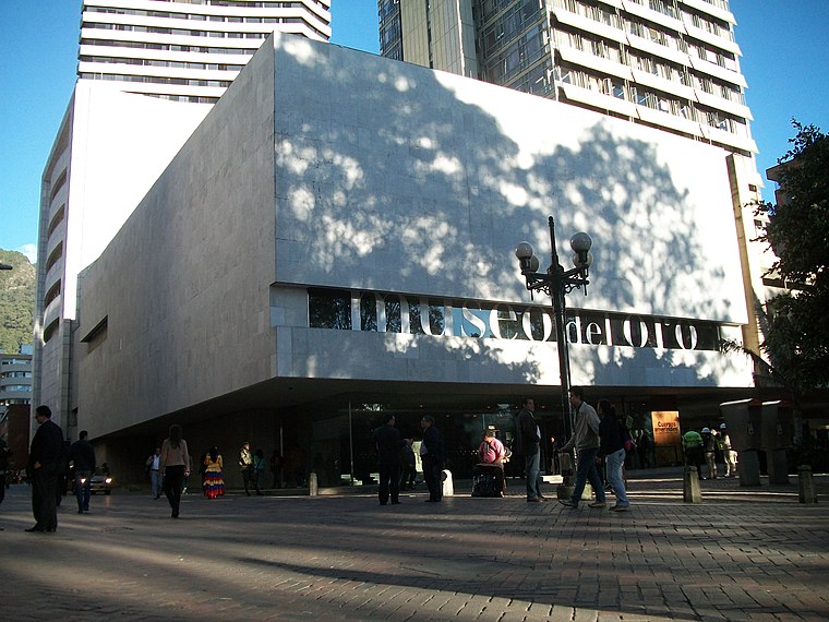
Photo: Pedro Felipe, CC BY-SA 3.0.
The Museum of Gold is an archaeology museum located in Bogotá, Colombia. It is one of the most visited touristic highlights in the country. The museum receives around 500,000 tourists per year.
Cathedral Metropolitan Basilica of Bogotá & Primate of Colombia
Church

Photo: Pedro Felipe, CC BY-SA 4.0.
The Metropolitan and Primate Cathedral Basilica of the Immaculate Conception and Saint Peter of Bogotá or better known as the Metropolitan Cathedral Basilica of Bogotá and Primate of Colombia, officially Sacred Holy Temple Metropolitan Cathedral Basilica and…
Casa de Nariño
Government office
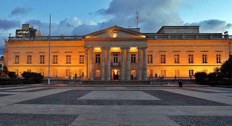
Photo: Juanjo70000, CC BY-SA 4.0.
The Casa de Nariño, literally the House of Nariño, is the official residence and principal workplace of the President of Colombia. It houses the main office of the executive branch and is located in the capital city of Bogotá, Colombia.
Places in the Area
Nearby places include Santa Fé-Los Mártires and Santa Fe.
Santa Fé-Los Mártires

Photo: Pedro Felipe, CC BY-SA 3.0.
Santa Fé is the traditional downtown of Bogotá, surrounding the historic district of La Candelaria. Los Mártires is the western end of downtown, and more rarely visited by foreigners, except to check out its sketchy market for extremely good deals.
Santa Fe
Suburb

Photo: Baiji, CC BY-SA 3.0.
Santa Fe is the third locality of Bogotá, the Capital District of Colombia. Santa Fe is part of the traditional downtown area where Bogotá was founded by Gonzalo Jiménez de Quesada on August 6, 1538.
Los Mártires
Suburb

Photo: Pedro Felipe, CC BY-SA 3.0.
Los Mártires is the 14th locality of Bogotá, capital of Colombia. It is located near the city's downtown to its west. This district is mostly inhabited by lower middle and working class residents.
La Candelaria
- Categories: cultural property, administrative territorial entity, human settlement, neighborhood, and locality
- Location: Candelaria, Bogotá D.C., Bogotá, Andino, Colombia, South America
- View on OpenStreetMap
Latitude
4.59682° or 4° 35′ 49″ northLongitude
-74.07167° or 74° 4′ 18″ westPopulation
24,100Elevation
2,662 metres (8,734 feet)Open location code
67P7HWWH+P8OpenStreetMap ID
node 7610998601OpenStreetMap feature
place=suburbGeoNames ID
6941779Wikidata ID
Q2651388
This page is based on OpenStreetMap, GeoNames, Wikidata, Wikimedia Commons, and Wikivoyage.
We’d love your help improving our open data sources. Thank you for contributing.
Satellite Map
Discover La Candelaria from above in high-definition satellite imagery.
In Other Languages
From Catalan to Swedish—“La Candelaria” goes by many names.
- Catalan: “La Candelaria”
- Catalan: “Mare de Déu de la Candela”
- Cebuano: “La Candelaria”
- Chinese: “拉坎德拉里亚”
- Chinese: “拉坎德拉里亞”
- Czech: “La Candelaria”
- Dutch: “La Candelaria”
- Esperanto: “La Candelaria”
- French: “La Candelaria”
- Galician: “La Candelaria”
- German: “La Candelaria”
- Indonesian: “La Candelaria”
- Italian: “La Candelaria”
- Japanese: “ラ・カンデラリア”
- Malay: “La Candelaria”
- Norwegian Bokmål: “La Candelaria”
- Norwegian: “La Candelaria”
- Polish: “La Candelaria”
- Portuguese: “La Candelaria”
- Slovenian: “La Candelaria”
- Spanish: “Candelaria”
- Spanish: “La Candelaria”
- Spanish: “Localidad 17”
- Swedish: “La Candelaria, Colombia”
- Swedish: “La Candelaria”
Places with the Same Name
Discover other places named “La Candelaria”.
Localities in the Area
Explore places such as La Concordia and Egipto.
Bogotá: Must-Visit Destinations
Delve into Santa Fé-Los Mártires, Zona Rosa, Usaquén, and Chapinero-Zona G.
Explore These Curated Destinations
Discover places selected for their distinct character and enduring appeal.
About Mapcarta. Data © OpenStreetMap contributors and available under the Open Database License". Text is available under the CC BY-SA 4.0 license, except for photos, directions, and the map. Description text is based on the Wikivoyage page “La Candelaria”. Photo: pat ossa, CC BY 2.0.