The Baths Supper Bar
The Baths Supper Bar is a fast food restaurant in England, United Kingdom which is located on Manchester Road. The Baths Supper Bar is situated nearby to the supermarket Unicorn Grocery, as well as near Field of Os Pocket Park.| Tap on a place to explore it |
- Type: Fast food restaurant
- Cuisine: regional and fish and chips
- Address: 113 Manchester Road, Manchester, M21 9PG
Places of Interest Nearby
Highlights include Unicorn Grocery and Old Trafford.
Unicorn Grocery
Supermarket

Photo: Peter McDermott, CC BY-SA 2.0.
Unicorn Grocery is a co-operative grocery store located in Chorlton-cum-Hardy, Manchester, England. As a workers co-op, it is controlled democratically by its members/owners, who run the business with a flat management structure and with an equal rate of pay.
Old Trafford
Stadium
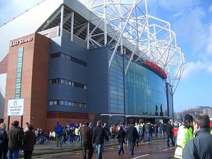
Photo: Wikimedia, Public domain.
Old Trafford is a football stadium in Old Trafford, Greater Manchester, England, and is the home of Manchester United. With a capacity of 74,197, it is the largest club football stadium in the United Kingdom, and the eleventh-largest in Europe. Old Trafford is situated 1¼ miles northwest of The Baths Supper Bar.
Chorlton Library
Library

Photo: Paul Ashwin, CC BY-SA 2.0.
Chorlton Library is situated 1,000 feet south of The Baths Supper Bar.
Places in the Area
Nearby places include Chorlton cum Hardy and Whalley Range.
Chorlton cum Hardy
Suburb
Photo: Phil Champion, CC BY-SA 2.0.
Chorlton-cum-Hardy is a suburban area of Manchester, England, three miles southwest of the city centre. Chorlton ward had a population of 14,138 at the 2011 census, and Chorlton Park 15,147.
Whalley Range
Suburb

Photo: R Greenhalgh, CC BY-SA 2.0.
Whalley Range is an area of Manchester, England, 2 miles south-west of the city centre. The population at the 2011 census was 15,430. Historically in Lancashire, it was one of the earliest of the city's suburbs, built by local businessman Samuel Brooks.
Chorltonville
Neighborhood

Photo: Rahotepuk, CC BY-SA 4.0.
Chorltonville is a garden village in Chorlton-cum-Hardy, Manchester, England. The village includes architecture inspired by the Arts and Crafts movement.
The Baths Supper Bar
- Categories: food and restaurant
- Location: England, United Kingdom, Britain and Ireland, Europe
- View on OpenStreetMap
Latitude
53.44727° or 53° 26′ 50″ northLongitude
-2.27744° or 2° 16′ 39″ westOpen location code
9C5VCPWF+W2OpenStreetMap ID
node 4947806423OpenStreetMap feature
amenity=fast_foodOpenStreetMap attribute
cuisine=regionalOpenStreetMap attribute
cuisine=fish_and_chips
This page is based on OpenStreetMap, Wikidata, and Wikimedia Commons.
We’d love your help improving our open data sources. Thank you for contributing.
Satellite Map
Discover The Baths Supper Bar from above in high-definition satellite imagery.
Notable Places Nearby
Highlights include Field of Os Pocket Park and Oswald Road Primary School.
Nearby Places
Explore places such as The Font and Mary & Archie Chorlton.
England: Must-Visit Destinations
Delve into London, Manchester, Sheffield, and Leeds.
Curious Fast Food Restaurants to Discover
Uncover intriguing fast food restaurants from every corner of the globe.
About Mapcarta. Data © OpenStreetMap contributors and available under the Open Database License". Text is available under the CC BY-SA 4.0 license, except for photos, directions, and the map. Photo: sidibousaid, CC BY 2.0.