SPRINGBANK ROAD-W/B
SPRINGBANK ROAD-W/B is a bus stop in Newcastle upon Tyne, England. SPRINGBANK ROAD-W/B is situated nearby to the church St Barnabas & St Jude, as well as near St Catherine’s RC Primary School.| Tap on a place to explore it |
Places of Interest Nearby
Highlights include St James’ Park and Jesmond Old Cemetery.
St James’ Park
Stadium
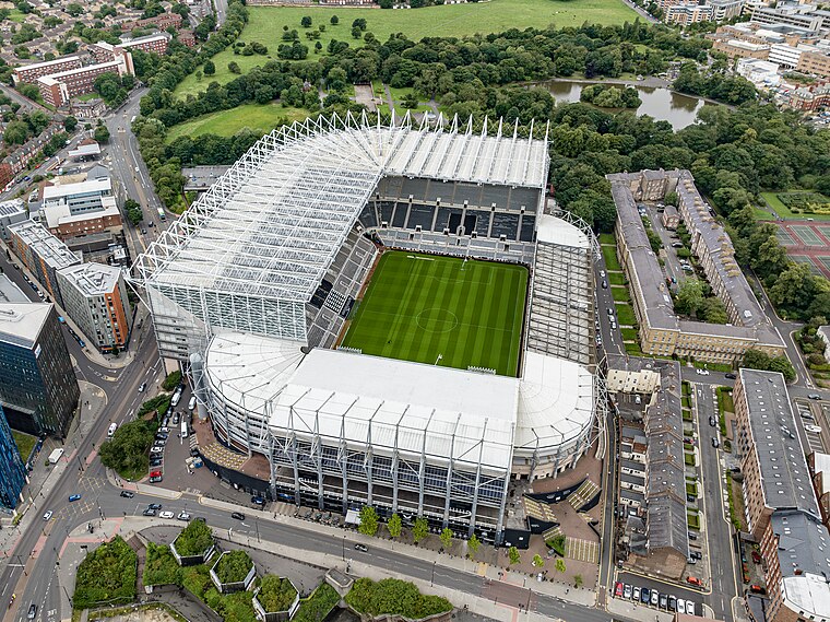
Photo: Arne mueseler, CC BY-SA 3.0 de.
St James' Park is a football stadium in Newcastle upon Tyne, England. It is the home of Newcastle United. With a seating capacity of 52,264, it is the 9th largest football stadium in England. St James’ Park is situated 1¼ miles southwest of SPRINGBANK ROAD-W/B.
Jesmond Old Cemetery
Cemetery

Photo: Andrew Curtis, CC BY-SA 2.0.
Jesmond Old Cemetery is a Victorian cemetery in Newcastle upon Tyne, United Kingdom, founded in 1834. It contains two Grade II listed buildings and seven Grade II listed monuments as well as the graves of dozens of notable people from the history of Tyneside. Jesmond Old Cemetery is situated 1,100 feet west of SPRINGBANK ROAD-W/B.
Jesmond Metro station
Railway station

Photo: Beeblebrox5000, Public domain.
Jesmond is a Tyne and Wear Metro station, serving the suburb of Jesmond, Newcastle upon Tyne in Tyne and Wear, England. It joined the network on 11 August 1980, following the opening of the first phase of the network, between Haymarket and Tynemouth via Four Lane Ends. Jesmond Metro station is situated 2,300 feet west of SPRINGBANK ROAD-W/B.
Places in the Area
Nearby places include Sandyford and Cradlewell.
Sandyford
Suburb
Sandyford is a small district in central Newcastle upon Tyne. It represents the north-eastern border of central Newcastle, with the suburbs of Jesmond to the north and Heaton to the east.
Cradlewell
Neighborhood
Cradlewell is an area within Jesmond, Newcastle upon Tyne, England. It is most noted for its spired church and its public house, 'The Cradlewell' which opened in 1904 and later closed, for conversion to a hotel & restaurant.

SPRINGBANK ROAD-W/B
- Type: Bus stop
- Category: transportation
- Location: Newcastle upon Tyne, England, United Kingdom, Britain and Ireland, Europe
- View on OpenStreetMap
Latitude
54.98251° or 54° 58′ 57″ northLongitude
-1.59449° or 1° 35′ 40″ westOpen location code
9C6WXCM4+26OpenStreetMap ID
node 502585389OpenStreetMap feature
highway=bus_stopOpenStreetMap feature
public_transport=platform
This page is based on OpenStreetMap, Wikidata, and Wikimedia Commons.
We’d love your help improving our open data sources. Thank you for contributing.
Satellite Map
Discover SPRINGBANK ROAD-W/B from above in high-definition satellite imagery.
Notable Places Nearby
Highlights include St Barnabas & St Jude and St Catherine’s RC Primary School.
Nearby Places
Explore places such as DINSDALE ROAD-NE/B and Mascalzone.
England: Must-Visit Destinations
Delve into London, Manchester, Sheffield, and Leeds.
Curious Bus Stops to Discover
Uncover intriguing bus stops from every corner of the globe.
About Mapcarta. Data © OpenStreetMap contributors and available under the Open Database License". Text is available under the CC BY-SA 4.0 license, except for photos, directions, and the map. Photo: sidibousaid, CC BY 2.0.