St Charles High School
St Charles High School is a school in Bangalore (North), Bengaluru Urban, Karnataka. St Charles High School is situated nearby to the government office Bangalore One, as well as near Pristine Hospital.| Tap on a place to explore it |
Places of Interest Nearby
Highlights include ISKCON Sri Radha Krishna-Chandra Temple and Rajajinagar metro station.
ISKCON Sri Radha Krishna-Chandra Temple
Hindu temple
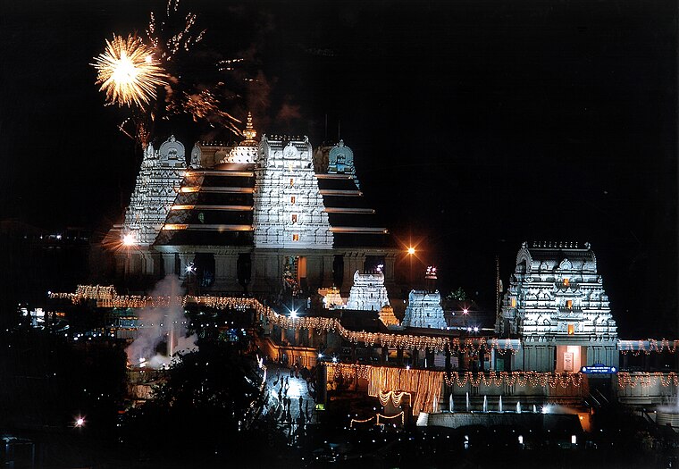 ISKCON Temple Bengaluru is one of the largest Krishna-Hindu temples in the world. It is situated in Bengaluru in the Indian state of Karnataka. The temple is dedicated to Hindu deities Radha Krishna and propagates monotheism as mentioned in Chandogya Upanishad. ISKCON Sri Radha Krishna-Chandra Temple is situated 2 km northeast of St Charles High School.
Rajajinagar metro station
Railway stop

Photo: LittleT889, CC BY-SA 4.0.
Rajajinagar is an elevated metro station on the North-South corridor of the Green Line of Namma Metro serving the Rajajinagar area of Bengaluru, India. Rajajinagar metro station is situated 1 km northeast of St Charles High School.
Mahakavi Kuvempu Road metro station
Railway stop

Photo: LittleT889, CC BY-SA 4.0.
Mahakavi Kuvempu Road is an elevated metro station on the North-South corridor of the Green Line of Namma Metro in Bengaluru, India. The station was constructed by Punj Lloyd - Sembawang Infrastructure JV, and was opened to the public on 1 March 2014. Mahakavi Kuvempu Road metro station is situated 1½ km east of St Charles High School.
Places in the Area
Nearby places include Basaveshwaranagara and Rajajinagar.
Basaveshwaranagara
Suburb
Basaveshwaranagara, also known as Basaveshwaranagar, Basaveshnagara or Basaveshnagar is a largely residential neighbourhood in the west of Bengaluru, Karnataka, India.
Rajajinagar
Suburb

Photo: Cv manjoo, CC BY-SA 3.0.
Rajajinagara is a luxury neighborhood and business hub in the west of Bangalore. It is one of the zones of BBMP. It is bordered by Basaveshwaranagara, Malleshwara, Mahalakshmipura alias West of Chord road second stage, Mahalakshmi Layout, Vijayanagara and Rajajinagara Industrial Suburb.
Mahalakshmi Layout
Suburb

Photo: Wikimedia, Public domain.
Mahalakshmi Layout, also known as Mahalakshmipuram is a neighborhood in northwest Bengaluru, India. It is near Rajajinagara, Basaveshwaranagara and Yeshwanthpura.
St Charles High School
- Type: School
- Address: Basaveshwara Nagar, Bangalore
- Category: education
- Location: Bangalore (North), Bengaluru Urban, Karnataka, Southern India, India, South Asia, Asia
- View on OpenStreetMap
Latitude
12.99652° or 12° 59′ 48″ northLongitude
77.54233° or 77° 32′ 32″ eastOpen location code
7J4VXGWR+JWOpenStreetMap ID
node 519549757OpenStreetMap feature
amenity=school
This page is based on OpenStreetMap, Wikidata, and Wikimedia Commons.
We’d love your help improving our open data sources. Thank you for contributing.
Satellite Map
Discover St Charles High School from above in high-definition satellite imagery.
Places with the Same Name
Discover other places named “St Charles High School”.
Notable Places Nearby
Highlights include Bangalore One and Pristine Hospital.
Nearby Places
Explore places such as SGR Pamphlets and Pizza Hut.
Karnataka: Must-Visit Destinations
Delve into Bangalore, Mysore, Mangalore, and Hampi.
Curious Schools to Discover
Uncover intriguing schools from every corner of the globe.
About Mapcarta. Data © OpenStreetMap contributors and available under the Open Database License". Text is available under the CC BY-SA 4.0 license, except for photos, directions, and the map. Photo: Pri2pais, CC BY-SA 3.0.