Ministry of Health & Family Welfare
Ministry of Health & Family Welfare is a government office in Chanakya Puri, New Delhi, Delhi which is located on Maulana Azad Road. Ministry of Health & Family Welfare is situated nearby to the government office National Buildings Organisation, as well as near Ministry of Housing and Urban Affairs.| Tap on a place to explore it |
Places of Interest Nearby
Highlights include India Gate and Gandhi Museum.
India Gate
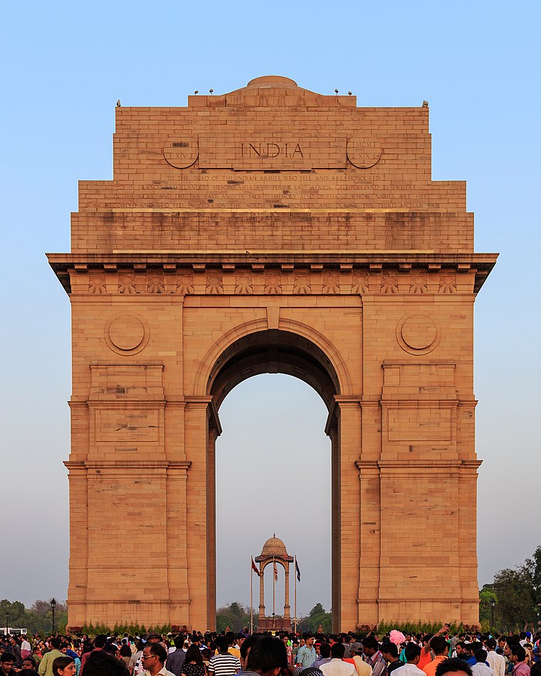 The India Gate is a war memorial located near the Rajpath on the eastern edge of the "ceremonial axis" of New Delhi. It stands as a memorial to 74,187 soldiers of the Indian Army who died between 1914 and 1921 in the First World War, in France, Flanders, Mesopotamia, Persia, East Africa, Gallipoli and elsewhere in the Near and the Far East, and the Third Anglo-Afghan War. India Gate is situated 1¼ km east of Ministry of Health & Family Welfare.
Gandhi Museum
Museum

Photo: Gaurav Vaidya, CC BY 3.0.
Gandhi Smriti, formerly known as Birla House or Birla Bhavan, is a museum dedicated to Mahatma Gandhi, situated on Tees January Road, formerly Albuquerque Road, in New Delhi, India. Gandhi Museum is situated 1 km south of Ministry of Health & Family Welfare.
Udyog Bhawan metro station
Metro station

Photo: Santosh4118, CC BY-SA 4.0.
The Udyog Bhawan metro station is located on the Yellow Line of the Delhi Metro. Motilal Nehru Place and the National Museum, Janpath are located nearby. Udyog Bhawan metro station is situated 420 metres west of Ministry of Health & Family Welfare.
Places in the Area
Nearby places include Raisina Hill and Eastern Delhi.
Raisina Hill
Neighborhood
 Raisina Hill, often used as a metonym for the seat of the Government of India, is an area of New Delhi, housing India's most important government buildings, including Rashtrapati Bhavan, the official residence of the President of India on a citadel and the Secretariat building, housing the Prime Minister's Office and several other important ministries.
Eastern Delhi

Photo: Wikimedia, CC BY-SA 3.0.
Eastern Delhi consists of three administrative districts: East Delhi, North East Delhi and Shahdara, which are all on the eastern bank of the Yamuna River. Akshardham is the most famous attraction in the district.
Rashtrapati Bhavan
Locality
 The Rashtrapati Bhavan is the official residence of the President of the Republic of India at the western end of Rajpath, Raisina Hill in New Delhi. It was constructed during the British Raj.
Ministry of Health & Family Welfare
- Type: Government office
- Address: Maulana Azad Road, New Delhi, 110011
- Categories: office and government building
- Location: Chanakya Puri, New Delhi, Delhi, Plains, India, South Asia, Asia
- View on OpenStreetMap
Latitude
28.61077° or 28° 36′ 39″ northLongitude
77.21588° or 77° 12′ 57″ eastOpen location code
7JWVJ668+89OpenStreetMap ID
node 5839953985OpenStreetMap feature
office=government
This page is based on OpenStreetMap, Wikidata, and Wikimedia Commons.
We’d love your help improving our open data sources. Thank you for contributing.
Satellite Map
Discover Ministry of Health & Family Welfare from above in high-definition satellite imagery.
In Other Languages
From Arabic to Spanish—“Ministry of Health & Family Welfare” goes by many names.
- Arabic: “وزارة الصحة ورعاية الأسرة”
- German: “Ministerium für Gesundheit und Familie”
- Portuguese: “Ministério da Saúde e Bem-Estar Familiar”
- Spanish: “Ministerio de Salud y Bienestar Familiar”
Notable Places Nearby
Highlights include National Buildings Organisation and Ministry of Housing and Urban Affairs.
Nearby Places
Explore places such as Nirman Bhavan and National Museum.
Delhi: Must-Visit Destinations
Delve into Central Delhi, Indira Gandhi International Airport, South East Delhi, and South Delhi.
Curious Government Offices to Discover
Uncover intriguing government offices from every corner of the globe.
About Mapcarta. Data © OpenStreetMap contributors and available under the Open Database License". Text is available under the CC BY-SA 4.0 license, except for photos, directions, and the map. Photo: Wikimedia, CC0.