Sirkeci Marmaray Underground Station
Sirkeci railway station, listed on maps as Istanbul railway station, is a railway terminal in Istanbul, Turkey. The terminal is located in Sirkeci, on the tip of Istanbul's historic peninsula, right next to the Golden Horn and just northwest of Gülhane Park and the Topkapı Palace.| Tap on a place to explore it |
Places of Interest Nearby
Highlights include Hagia Sophia and Topkapı Palace.
Hagia Sophia
Mosque

Photo: Myrabella, Public domain.
Hagia Sophia, officially the Hagia Sophia Grand Mosque, is a mosque and former museum and church serving as a major cultural and historical site in Istanbul, Turkey. Hagia Sophia is situated 620 metres southeast of Sirkeci Marmaray Underground Station.
Topkapı Palace
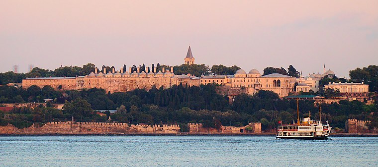
Photo: Uspn, CC BY-SA 3.0.
The Topkapı Palace or the Seraglio, is a large museum and library in the east of the Fatih district of Istanbul in Turkey. From the 1460s to the completion of Dolmabahçe Palace in 1856, it served as the administrative center of the Ottoman Empire, and was the main residence of its sultans. Topkapı Palace is situated 580 metres east of Sirkeci Marmaray Underground Station.
Istanbul Archaeology Museums
Museum

Photo: Metuboy, CC BY-SA 4.0.
The Istanbul Archaeology Museums are a group of three archaeological museums located in the Eminönü quarter of Istanbul, Turkey, near Gülhane Park and Topkapı Palace. Istanbul Archaeology Museums is situated 400 metres southeast of Sirkeci Marmaray Underground Station.
Places in the Area
Nearby places include Eminönü and Mollafenari.
Eminönü
Quarter

Photo: HALUK COMERTEL, CC BY 3.0.
Eminönü, historically known as Pérama, is a predominantly commercial waterfront area of Istanbul within the Fatih district near the confluence of the Golden Horn with the southern entrance of the Bosphorus strait and the Sea of Marmara.
Mollafenari
Suburb

Photo: Bahnfrend, CC BY-SA 4.0.
Mollafenari is a neighbourhood in the municipality and district of Fatih, Istanbul Province, Turkey. Its population is 99. It is on the European side of Istanbul.

Sirkeci Marmaray Underground Station
- Type: Railway station
- Also known as: “Sirkeci”
- Categories: station and transportation
- Location: Historical Peninsula, Istanbul, Turkey, Middle East, Asia
- View on OpenStreetMap
Latitude
41.01361° or 41° 0′ 49″ northLongitude
28.97714° or 28° 58′ 38″ eastOperator
TCDD TaşımacılıkNetwork
Turkish State RailwaysOpen location code
8GHC2X7G+CVOpenStreetMap ID
node 6395978813OpenStreetMap feature
public_transport=stationOpenStreetMap feature
railway=station
This page is based on OpenStreetMap, Wikidata, Wikimedia Commons, and Wikipedia.
We’d love your help improving our open data sources. Thank you for contributing.
Satellite Map
Discover Sirkeci Marmaray Underground Station from above in high-definition satellite imagery.
Notable Places Nearby
Highlights include Seres Hotel and Seher Hotel.
Nearby Places
Explore places such as Magic Lamp Factory Outlet and Asilzade Hotel.
Turkey: Must-Visit Destinations
Delve into Istanbul, Edirne, Ankara, and Izmir.
Curious Railway Stations to Discover
Uncover intriguing railway stations from every corner of the globe.
About Mapcarta. Data © OpenStreetMap contributors and available under the Open Database License". Text is available under the CC BY-SA 4.0 license, except for photos, directions, and the map. Description text is based on the Wikipedia page “Sirkeci Marmaray Underground Station”. Photo: Martin-D, CC BY-SA 2.5.