Chemin Vert - Saint-Maur
Chemin Vert - Saint-Maur is a bike rental in Paris, Île-de-France. Chemin Vert - Saint-Maur is situated nearby to the art gallery Jung, as well as near the theater building Comédie Oberkampf.| Tap on a place to explore it |
Places of Interest Nearby
Highlights include Père Lachaise Cemetery and Atelier des Lumières.
Père Lachaise Cemetery

Photo: Coyau, CC BY-SA 3.0.
The 20th arrondissement of Paris lies to the east of the centre and represents an old working-class area now in rapid transformation. The main drawing card here for tourists is the Père-Lachaise Cemetery, though, for travellers who are interested in music and culture, this relatively gritty area is probably going to be one of your main night-crawling areas. Père Lachaise Cemetery is situated 1 km east of Chemin Vert - Saint-Maur.

Bataclan
Theater building
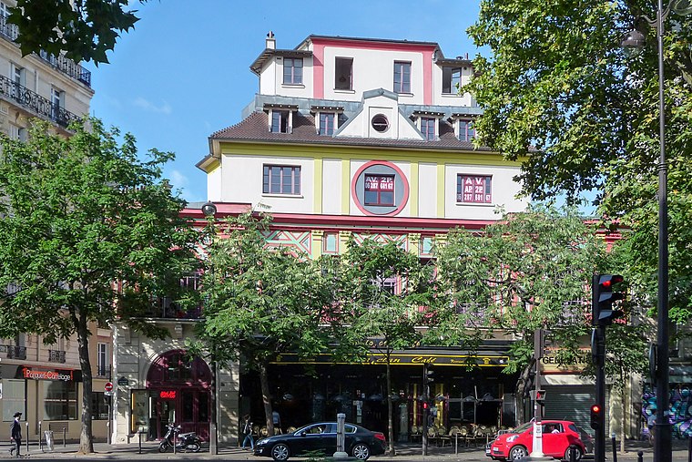
Photo: Wikimedia, CC BY-SA 3.0.
The Bataclan is a theatre located at 50 Boulevard Voltaire in the 11th arrondissement of Paris, France. Designed in 1864 by the architect Charles Duval, its name refers to Ba-ta-clan, an operetta by Jacques Offenbach. Bataclan is situated 1 km west of Chemin Vert - Saint-Maur.
Places in the Area
Nearby places include 11th arrondissement and Ménilmontant.
11th arrondissement

Photo: ParisSharing, CC BY 2.0.
The 11th Arrondissement is home to two quite different but equally blossoming centres of Parisian nightlife. The streets just northwest of Place de la Bastille are full of little bars which attract a mix of young suburban Parisians, expats, and foreigners.
Ménilmontant
Suburb
 Ménilmontant is a neighbourhood of Paris, situated in the city's 20th arrondissement. It is roughly defined as the area north of the Père Lachaise Cemetery, south of Parc de Belleville, and between Avenue Jean-Aicard on the west and Rue Pelleport on the east.
Faubourg Saint-Antoine
Suburb

Photo: Jean-François Gornet, CC BY-SA 2.0.
The Faubourg Saint-Antoine was one of the traditional suburbs of Paris, France. It grew up to the east of the Bastille around the abbey of Saint-Antoine-des-Champs, and ran along the Rue du Faubourg Saint-Antoine.
Chemin Vert - Saint-Maur
- Type: Bike rental
- Description: bicycle-sharing station of Vélib’ Métropole network
- Categories: bicycle-sharing station and transportation
- Location: Paris, Île-de-France, France, Europe
- View on OpenStreetMap
Latitude
48.86118° or 48° 51′ 40″ northLongitude
2.38133° or 2° 22′ 53″ eastBrand
Vélib‘ MétropoleOperator
SmovengoNetwork
Vélib‘ MétropoleOpen location code
8FW4V96J+FGOpenStreetMap ID
node 6437112096OpenStreetMap feature
amenity=bicycle_rentalWikidata ID
Q86254487
This page is based on OpenStreetMap, Wikidata, and Wikimedia Commons.
We’d love your help improving our open data sources. Thank you for contributing.
Satellite Map
Discover Chemin Vert - Saint-Maur from above in high-definition satellite imagery.
In Other Languages
“Chemin Vert - Saint-Maur” goes by many names.
- French: “Chemin Vert - Saint-Maur”
Places with the Same Name
Discover other places named “Chemin Vert - Saint-Maur”.
Notable Places Nearby
Highlights include Jung and Comédie Oberkampf.
Nearby Places
Explore places such as Le Servan and El Arzé.
Paris: Must-Visit Destinations
Delve into La Défense, 1st arrondissement, 7th arrondissement, and 8th arrondissement.
Curious Bike Rentals to Discover
Uncover intriguing bike rentals from every corner of the globe.
About Mapcarta. Data © OpenStreetMap contributors and available under the Open Database License". Text is available under the CC BY-SA 4.0 license, except for photos, directions, and the map. Photo: Benh, CC BY-SA 4.0.