Niederkorn, Hahneboesch
Niederkorn, Hahneboesch is a bus stop in Differdange, Esch-sur-Alzette. Niederkorn, Hahneboesch is situated nearby to the stadium Stade Jos Haupert, as well as near the sports venue Star Gym.| Tap on a place to explore it |
Places of Interest Nearby
Highlights include Stade Jos Haupert and Pétange railway station.
Stade Jos Haupert
Stadium
Stade Jos Haupert is a football stadium in Niederkorn, in southwestern Luxembourg. It is currently the home stadium of FC Progrès Niederkorn. The stadium has a capacity of 1,976 including 576 seats on main stand. Stade Jos Haupert is situated 180 metres north of Niederkorn, Hahneboesch.
Pétange railway station
Railway station

Photo: GilPe, CC BY-SA 4.0.
Pétange railway station is a railway station serving Pétange, in south-western Luxembourg. It is operated by Chemins de Fer Luxembourgeois, the state-owned railway company. Pétange railway station is situated 2 km northwest of Niederkorn, Hahneboesch.
Sanem Castle
Castle
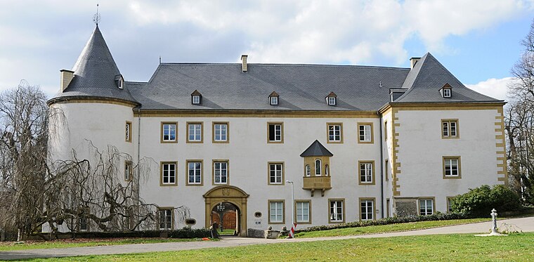
Photo: Cayambe, CC BY-SA 1.0.
Sanem Castle, located in the village of Sanem near Esch-sur-Alzette in south-western Luxembourg has a history dating back to the 13th century. Today's building was completed in 1557 after the medieval castle had been partly destroyed. Sanem Castle is situated 1½ km east of Niederkorn, Hahneboesch.
Places in the Area
Nearby places include Niederkorn and Linger.
Niederkorn
Village

Photo: Jwh, CC BY-SA 3.0 lu.
Niederkorn is a town in the commune of Differdange, in south-western Luxembourg, on the Chiers river, from which it takes its name. As of 2024, the town has a population of 7,663.
Linger
Village

Photo: Pecalux, CC BY-SA 3.0.
Linger is a small town in the commune of Bascharage, in south-western Luxembourg. As of 2023, the town has a population of 629. Linger is situated 2½ km northwest of Niederkorn, Hahneboesch.
Fond-de-Gras
Hamlet

Photo: Wikimedia, Public domain.
Fond-de-Gras is a hamlet, which is situated 3 km west of Niederkorn, Hahneboesch.
Niederkorn, Hahneboesch
- Type: Bus stop
- Categories: transport stop and transportation
- Location: Differdange, Esch-sur-Alzette, Luxembourg, Benelux, Europe
- View on OpenStreetMap
Latitude
49.54427° or 49° 32′ 39″ northLongitude
5.9018° or 5° 54′ 7″ eastOpen location code
8FX7GWV2+PPOpenStreetMap ID
node 7077956622OpenStreetMap feature
public_transport=stop_position
This page is based on OpenStreetMap, Wikidata, and Wikimedia Commons.
We’d love your help improving our open data sources. Thank you for contributing.
Satellite Map
Discover Niederkorn, Hahneboesch from above in high-definition satellite imagery.
Notable Places Nearby
Highlights include Star Gym and Hahnebësch.
Nearby Places
Explore places such as Niederkorn, Hahneboesch and Nic Wilwert & Fils.
Luxembourg: Must-Visit Destinations
Delve into Luxembourg, Central Luxembourg, Schengen, and Echternach.
Curious Bus Stops to Discover
Uncover intriguing bus stops from every corner of the globe.
About Mapcarta. Data © OpenStreetMap contributors and available under the Open Database License". Text is available under the CC BY-SA 4.0 license, except for photos, directions, and the map. Photo: Michal Osmenda, CC BY-SA 2.0.