Closed road, no way to border
Closed road, no way to border is in Ma’an Governorate, Jordan. Closed road, no way to border is situated nearby to the grassland Driving Range, as well as near the nature reserve Aqaba Bird Observatory.| Tap on a place to explore it |
Places of Interest Nearby
Highlights include Ice Mall and Eilat Marina.
Ice Mall
Shopping center
 Ice Mall is a shopping center, which is situated 3 km southwest of Closed road, no way to border.

Eilat Airport
Building
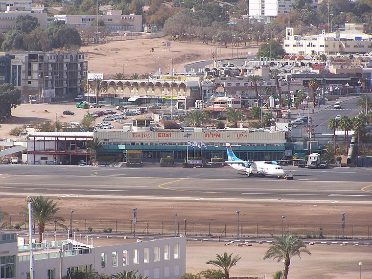
Photo: Sendelbach, CC BY-SA 3.0.
Eilat Airport, also known as J. Hozman Airport, was an airport located in Eilat, Israel. It was named after Arkia Airlines founder Yakov Hozman and was located in the center of Eilat adjacent to Route 90. Eilat Airport is situated 4 km southwest of Closed road, no way to border.
Places in the Area
Nearby places include Tall al Khalifa and Eilot.
Tall al Khalifa
Village
Tell el-Kheleifeh is an archaeological site in Jordan at the head of the Gulf of Aqaba immediately northwest of the city of Aqaba. Its older identification with the 10th-century port from the biblical King Solomon narrative does not stand up to newer…
Eilot
Village

Photo: Wikimedia, Public domain.
Eilot is the southernmost kibbutz in Israel. It is located in the Aravah Valley, near the border with Jordan. Eilot is less than a kilometer north of Eilat, and just over 3 kilometers north of the Red Sea. Eilot is situated 3 km northwest of Closed road, no way to border.
Eilat

Photo: Chris Yunker, CC BY-SA 2.0.
Eilat is the only Israeli city on the Red Sea. Eilat is the southernmost town in Israel, isolated from the rest of the country by the Negev desert. It's sandwiched between Taba in Egypt and Aqaba in Jordan, and often used as an access route to those cities because of its large modern Ramon airport.
Closed road, no way to border
- Type: Information
- Category: tourism
- Location: Ma’an Governorate, Jordan, Middle East, Asia
- View on OpenStreetMap
Latitude
29.56799° or 29° 34′ 5″ northLongitude
34.99249° or 34° 59′ 33″ eastOpen location code
7GXPHX9R+5XOpenStreetMap ID
node 7169259085OpenStreetMap feature
tourism=information
This page is based on OpenStreetMap, Wikidata, and Wikimedia Commons.
We’d love your help improving our open data sources. Thank you for contributing.
Satellite Map
Discover Closed road, no way to border from above in high-definition satellite imagery.
Notable Places Nearby
Highlights include Driving Range and Aqaba Bird Observatory.
Nearby Places
Explore places such as Can’t walk to the border from this road and Ayla Golf Club.
Curious Places to Discover
Uncover intriguing places from every corner of the globe.
About Mapcarta. Data © OpenStreetMap contributors and available under the Open Database License". Text is available under the CC BY-SA 4.0 license, except for photos, directions, and the map. Photo: Wikimedia, CC0.