Community Garden
Community Garden is a garden in Brisbane, Queensland. Community Garden is situated nearby to the public building New Den, as well as near the park St Johns Wood.| Tap on a place to explore it |
Places of Interest Nearby
Highlights include Lang Park and Mt St Michael’s College.
Lang Park
Stadium
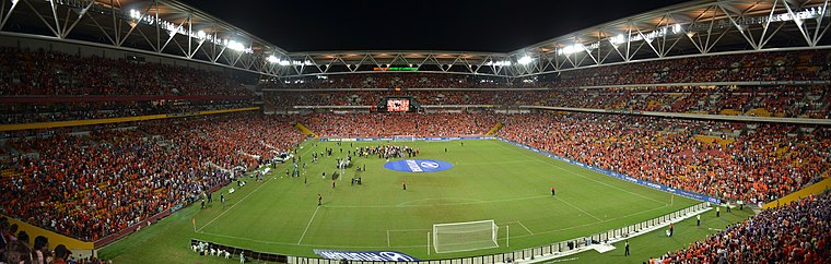 Brisbane Stadium, currently known as Suncorp Stadium for sponsorship reasons, is a multi-purpose stadium in the suburb of Milton, Brisbane, Queensland, Australia. Lang Park is situated 4 km southeast of Community Garden.
Mt St Michael’s College
School
Mt St Michael's College is an independent Catholic secondary school for girls located in Ashgrove, Brisbane, Queensland, Australia. It was established in 1925 by the Sisters of Charity at the invitation of James Duhig the Roman Catholic Archbishop of Brisbane. Mt St Michael’s College is situated 1¼ km east of Community Garden.
Brisbane Botanic Gardens
Park

Photo: Figaro, Public domain.
The Brisbane Botanic Gardens are located 7 kilometres from the Brisbane CBD at the foot of Brisbane's tallest mountain, Mount Coot-tha in the suburb of Mount Coot-tha, Queensland, Australia. Brisbane Botanic Gardens is situated 3½ km south of Community Garden.
Places in the Area
Nearby places include Ithaca and Red Hill.
Ithaca
Neighborhood
Ithaca is a former suburb of Brisbane, Australia. Since 1975, Ithaca has been designated a neighbourhood within the suburb of Red Hill in Brisbane.
Red Hill
Suburb
Red Hill is an inner northern suburb in the City of Brisbane, Queensland, Australia. In the 2021 census, Red Hill had a population of 5,834 people. Red Hill is situated 3½ km east of Community Garden.
Newmarket
Suburb
Newmarket is a north-west suburb in the City of Brisbane, Queensland, Australia. In the 2021 census, Newmarket had a population of 5,083 people. Newmarket is situated 3½ km east of Community Garden.
Community Garden
- Type: Garden
- Category: recreation area
- Location: Brisbane, Queensland, Australia, Oceania
- View on OpenStreetMap
Latitude
-27.44674° or 27° 26′ 48″ southLongitude
152.97495° or 152° 58′ 30″ eastOpen location code
5R4JHX3F+8XOpenStreetMap ID
node 7461105861OpenStreetMap feature
leisure=garden
This page is based on OpenStreetMap, Wikidata, and Wikimedia Commons.
We’d love your help improving our open data sources. Thank you for contributing.
Satellite Map
Discover Community Garden from above in high-definition satellite imagery.
Places with the Same Name
Discover other places named “Community Garden”.
Notable Places Nearby
Highlights include New Den and St Johns Wood.
Nearby Places
Explore places such as Royal Parade near Gresham Street stop 26 and Gresham Street near Royal Parade stop 25a.
Queensland: Must-Visit Destinations
Delve into Brisbane, Gold Coast, Sunshine Coast, and Cairns.
Curious Gardens to Discover
Uncover intriguing gardens from every corner of the globe.
About Mapcarta. Data © OpenStreetMap contributors and available under the Open Database License". Text is available under the CC BY-SA 4.0 license, except for photos, directions, and the map. Photo: Wikimedia, CC0.