Tower & Castle
Tower & Castle is a café in Kilkenny, Leinster which is located on John Street Upper. Tower & Castle is situated nearby to the recreation area Brogan’s Yard, as well as near the church St. John’s Priory.| Tap on a place to explore it |
- Opening hours:
Monday—Friday: 7:15 AM—4:00 PM
Saturday and Sunday: 9:00 AM—5:00 PM - Type: Café
- Address: John Street Upper, Kilkenny
Places of Interest Nearby
Highlights include St John’s Priory and Kilkenny Castle.
St John’s Priory

Photo: JohnArmagh, CC BY-SA 3.0.
St John's Priory, is a medieval Augustinian priory and National Monument located in Kilkenny City, Ireland. The Lady Chapel of the priory is now used as a parish church of the Church of Ireland.
Kilkenny Castle
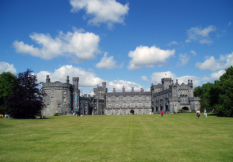
Photo: Tolivero, Public domain.
Kilkenny Castle is a castle in Kilkenny, Ireland, built in 1260 to control a fording-point of the River Nore and the junction of several routeways. It was a symbol of Norman occupation, and in its original 13th-century condition, it would have formed… Kilkenny Castle is situated 400 metres south of Tower & Castle.
County Hall
Town hall

Photo: 瑞丽江的河水, CC BY-SA 4.0.
County Hall is a municipal facility in Kilkenny, County Kilkenny, Ireland. County Hall is situated 150 metres south of Tower & Castle.
Places in the Area
Nearby places include Johnswell and Bennettsbridge.
Johnswell
Locality

Photo: liam murphy, CC BY-SA 2.0.
Johnswell is a village in County Kilkenny, Ireland. On the village green is a powerful spring and well dedicated to John the Baptist which was traditionally the venue for a local "pattern" of note, while the moat north of the village was the site of St John's Eve bonfires. Johnswell is situated 7 km northeast of Tower & Castle.
Bennettsbridge
Village

Photo: Sarah777, Public domain.
Bennettsbridge is a village in County Kilkenny in Ireland. It is situated on the River Nore 6 kilometres south of Kilkenny city, in the centre of the county. Bennettsbridge is situated 8 km southeast of Tower & Castle.
Tower & Castle
- Location: Kilkenny, Leinster, Ireland, Britain and Ireland, Europe
- View on OpenStreetMap
Latitude
52.65377° or 52° 39′ 14″ northLongitude
-7.24776° or 7° 14′ 52″ westOpen location code
9C4JMQ32+GVOpenStreetMap ID
node 8274947107OpenStreetMap feature
amenity=cafe
This page is based on OpenStreetMap, Wikidata, and Wikimedia Commons.
We’d love your help improving our open data sources. Thank you for contributing.
Satellite Map
Discover Tower & Castle from above in high-definition satellite imagery.
Notable Places Nearby
Highlights include Brogan’s Yard and St. John’s Priory.
Nearby Places
Explore places such as Kilkenny City Hostel and The Blue Door.
Ireland: Must-Visit Destinations
Delve into Dublin, Cork, Limerick, and Galway.
Curious Cafés to Discover
Uncover intriguing cafés from every corner of the globe.
About Mapcarta. Data © OpenStreetMap contributors and available under the Open Database License". Text is available under the CC BY-SA 4.0 license, except for photos, directions, and the map. Photo: AFBorchert, CC BY-SA 3.0.