IKA
IKA is a taxicab stand in Rhodes, Dodecanese, South Aegean Islands. IKA is situated nearby to C.A.I.R. winery, as well as near Rodos Arena Park.| Tap on a place to explore it |
Places of Interest Nearby
Highlights include Rodini Park and Acropolis of Rhodes.

Acropolis of Rhodes
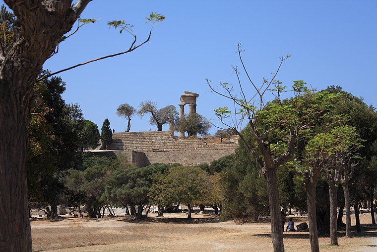
Photo: MattiPaavola, CC BY-SA 3.0.
The Acropolis of Rhodes is the acropolis, or upper town, of ancient Rhodes dating from the 5th century BC and located 3 kilometers SW from the centre of the modern city. Acropolis of Rhodes is situated 3 km north of IKA.
Muslim Library of Hafiz Ahmed Aga
Library

Photo: Bgag, CC BY-SA 4.0.
Hafiz Ahmed Agha Library is an important historic Ottoman building in the medieval city of Rhodes in Greece, a UNESCO World Heritage Site. The library was founded by Hafiz Ahmed Agha in 1793. Muslim Library of Hafiz Ahmed Aga is situated 3½ km north of IKA.
Places in the Area
Nearby places include Koskinou and Medieval city of Rhodes.
Koskinou
Town
Koskinou is a village on the Greek island of Rhodes. It is located 5 miles from Rhodes town and 6 miles from the island resort of Faliraki and the Music School of Rhodes. Koskinou is situated 3 km south of IKA.
Medieval city of Rhodes
Suburb

Photo: Olbertz, CC BY-SA 3.0.
The Medieval City of Rhodes was constructed around 1309 to 1523 and is part of the modern capital city of Rhodes on the Island of Rhodes in Greece. The site was added to the UNESCO World Heritage list in 1988. Medieval city of Rhodes is situated 3½ km northeast of IKA.
Rhodes

Photo: Xlibber, CC BY-SA 2.0.
Rhodes is the largest settlement and capital city of the island of the same name. It is famous as the former site of the Colossus, one of the seven wonders of the ancient world, and as the oldest inhabited medieval town in Europe.
IKA
- Type: Taxicab stand
- Category: transportation
- Location: Rhodes, Dodecanese, South Aegean Islands, Greek Islands, Greece, Balkans, Europe
- View on OpenStreetMap
Latitude
36.41424° or 36° 24′ 51″ northLongitude
28.20972° or 28° 12′ 35″ eastOpen location code
8G8CC675+MVOpenStreetMap ID
node 8541197119OpenStreetMap feature
amenity=taxi
This page is based on OpenStreetMap, Wikidata, and Wikimedia Commons.
We’d love your help improving our open data sources. Thank you for contributing.
Satellite Map
Discover IKA from above in high-definition satellite imagery.
In Other Languages
“IKA” goes by many names.
- Greek: “ΙΚΑ”
Places with the Same Name
Discover other places named “IKA”.
Notable Places Nearby
Highlights include C.A.I.R. winery and Rodos Arena Park.
Nearby Places
Explore places such as IKA and Top FM.
Rhodes: Must-Visit Destinations
Delve into Rhodes, Lindos, Ialysos, and Faliraki.
Curious Taxicab Stands to Discover
Uncover intriguing taxicab stands from every corner of the globe.
About Mapcarta. Data © OpenStreetMap contributors and available under the Open Database License". Text is available under the CC BY-SA 4.0 license, except for photos, directions, and the map. Photo: Tango7174, CC BY-SA 4.0.