Tino’s Italian Grocery
Tino’s Italian Grocery is a supermarket in Santa Barbara County, Central Coast, California which is located on West Carrillo Street. Tino’s Italian Grocery is situated nearby to the health club Bond Fitness, as well as near the fire station City of Santa Barbara Fire Stn 1.| Tap on a place to explore it |
- Opening hours:
Monday—Saturday: 9:00 AM—5:00 PM
Sunday and public holidays: closed - Type: Supermarket
- Address: 210 West Carrillo Street, Santa Barbara, CA 93101
- Wheelchair access: yes
Places of Interest Nearby
Highlights include Casa Dolores and Karpeles Manuscript Library Museum, Santa Barbara.
Casa Dolores
Museum
Casa Dolores, Center for the Study of the Popular Arts of Mexico is an art museum located on 1023 Bath Street in Santa Barbara, California. The center is devoted to the collection, preservation, exhibition, and study of the popular arts throughout Mexico. Casa Dolores is situated 530 feet west of Tino’s Italian Grocery.
Karpeles Manuscript Library Museum, Santa Barbara
Museum

Photo: Peaceray, CC BY-SA 4.0.
Karpeles Manuscript Library Museum, Santa Barbara is situated 1,200 feet north of Tino’s Italian Grocery.
Santa Barbara Museum of Art
Museum
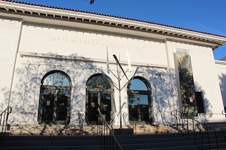
Photo: Jllm06, CC BY-SA 3.0.
The Santa Barbara Museum of Art is an art museum located in downtown Santa Barbara, California, United States. Founded in 1941, it is home to both permanent and special collections, the former of which includes Asian, American, and European art that spans 4,000 years from ancient to modern. Santa Barbara Museum of Art is situated 1,500 feet north of Tino’s Italian Grocery.
Places in the Area
Nearby places include Santa Barbara and Mission Canyon.
Santa Barbara

Photo: Raduranga, CC BY-SA 4.0.
Santa Barbara is a city and metropolitan area less than 100 miles from Los Angeles but vastly different in pace from its huge neighbor to the south. With a temperate climate and lush natural environs, the "Riviera of the West" is a pleasant day or weekend trip from L.A.
Mission Canyon
Village

Photo: Arminnius, CC BY-SA 4.0.
Mission Canyon is a census-designated place and an unincorporated suburb of Santa Barbara, California, in Santa Barbara County, United States. The population was 2,540 at the 2020 census, up from 2,381 at the 2010 census. Mission Canyon is situated 2 miles north of Tino’s Italian Grocery.
Hope Ranch
Hamlet

Photo: Antandrus, Public domain.
Hope Ranch is an unincorporated coastal suburb of Santa Barbara, California, located in Santa Barbara County. It is bounded on the east by Santa Barbara, on the north and west by the unincorporated area of the eastern Goleta Valley, and on the south by the Pacific Ocean. Hope Ranch is situated 4 miles west of Tino’s Italian Grocery.
Tino’s Italian Grocery
- Categories: shop and food
- Location: Santa Barbara County, Central Coast, California, United States, North America
- View on OpenStreetMap
Latitude
34.41923° or 34° 25′ 9″ northLongitude
-119.70461° or 119° 42′ 17″ westOpen location code
8562C79W+M5OpenStreetMap ID
node 8884016492OpenStreetMap feature
shop=supermarketOpenStreetMap attribute
wheelchair=yes
This page is based on OpenStreetMap, Wikidata, and Wikimedia Commons.
We’d love your help improving our open data sources. Thank you for contributing.
Satellite Map
Discover Tino’s Italian Grocery from above in high-definition satellite imagery.
Notable Places Nearby
Highlights include Bond Fitness and City of Santa Barbara Fire Stn 1.
Nearby Places
Explore places such as Starbucks and Spudnuts.
Santa Barbara County: Must-Visit Destinations
Delve into Santa Barbara, Santa Maria, Solvang, and Carpinteria.
Curious Supermarkets to Discover
Uncover intriguing supermarkets from every corner of the globe.
About Mapcarta. Data © OpenStreetMap contributors and available under the Open Database License". Text is available under the CC BY-SA 4.0 license, except for photos, directions, and the map. Photo: Wikimedia, CC0.