Slavyanskaya Square
Slavyanskaya Square is a square in central Moscow, renamed in 1924–1990 as northern side of Nogina Square; the southern side of Soviet-era Nogina Square reverted to its old name Varvarka Gates Square.| Tap on a place to explore it |
Photo: Hshuvaeva, Public domain.
Places of Interest Nearby
Highlights include Bolshoi Theatre and Moscow Choral Synagogue.
Bolshoi Theatre
Theater building
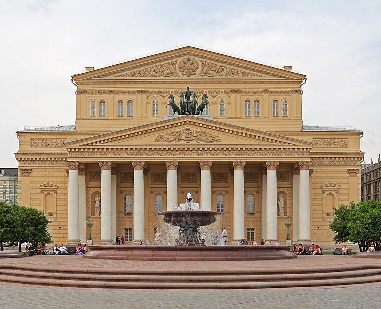
Photo: A.Savin, CC BY-SA 3.0.
The Bolshoi Theatre is a historic opera house in Moscow, Russia, originally designed by architect Joseph Bové. Before the October Revolution it was a part of the Imperial Theatres of the Russian Empire along with Maly Theatre in Moscow and a few theatres in Saint Petersburg. Bolshoi Theatre is situated 1¼ km northwest of Slavyanskaya Square.
Moscow Choral Synagogue
Synagogue
 The Moscow Choral Synagogue is an Orthodox Jewish congregation and synagogue, located at 10 Bolshoy Spasoglinischevsky Lane, in the central Basmanny District of Moscow, Russia. Moscow Choral Synagogue is situated 170 metres north of Slavyanskaya Square.
Kitay-gorod
Metro station
Kitay-gorod is a Moscow Metro station complex in the Tverskoy District, Central Administrative Okrug, Moscow, Russia. It is on the Kaluzhsko-Rizhskaya and Tagansko-Krasnopresnenskaya lines. Kitay-gorod is situated 200 metres north of Slavyanskaya Square.
Places in the Area
Nearby places include Central-East and Kitay-gorod.
Central-East

Photo: Antares 610, CC BY-SA 3.0.
Moscow Central-East is in Moscow also part of Central Moscow.
Kitay-gorod
Neighborhood

Photo: Matthäus Merian the Elder, Public domain.
Kitay-gorod, also referred to as the Great Possad in the 16th and 17th centuries, is a cultural and historical area within the central part of Moscow in Russia, defined by the remnants of now almost entirely razed fortifications, narrow streets and very densely built cityscape.
Central Moscow

Photo: Ludvig14, CC BY-SA 3.0.
Central Administrative Okrug, or Tsentralny Administrativny Okrug, is one of the twelve administrative okrugs of Moscow, Russia. Population: 772,258 ; 741,967 ; 701,353 .
Slavyanskaya Square
- Type: Square
- Description: public square in Russia
- Category: locality
- Location: Moscow Oblast, Central Russia, Russia, Eastern Europe, Europe
- View on OpenStreetMap
Latitude
55.75397° or 55° 45′ 14″ northLongitude
37.63464° or 37° 38′ 5″ eastOpen location code
9G7VQJ3M+HVOpenStreetMap ID
node 8950592419OpenStreetMap feature
place=squareWikidata ID
Q4423055
This page is based on OpenStreetMap, Wikidata, Wikimedia Commons, and Wikipedia.
We’d love your help improving our open data sources. Thank you for contributing.
Satellite Map
Discover Slavyanskaya Square from above in high-definition satellite imagery.
In Other Languages
From Chinese to Tatar—“Slavyanskaya Square” goes by many names.
- Chinese: “斯拉彥卡亞廣場”
- Egyptian Arabic: “ميدان سلافيانسكايا”
- Italian: “Piazza Slavjanskaja”
- Japanese: “スラヴィヤンスカヤ広場”
- Russian: “Славянская площадь (Москва)”
- Russian: “Славянская площадь”
- Tatar: “Славян мәйданы”
Notable Places Nearby
Highlights include Президентская библиотека им. Б. Н. Ельцина. Резервный центр в Москве and Cyril and Methodius.
Nearby Places
Explore places such as Метро «Китай-город» and Метро «Китай-город».
Moscow Oblast: Must-Visit Destinations
Delve into Moscow, Outskirts, Podolsk, and Kolomna.
Curious Squares to Discover
Uncover intriguing squares from every corner of the globe.
About Mapcarta. Data © OpenStreetMap contributors and available under the Open Database License". Text is available under the CC BY-SA 4.0 license, except for photos, directions, and the map. Description text is based on the Wikipedia page “Slavyanskaya Square”. Photo: Hshuvaeva, Public domain.