Splitterheim
Splitterheim is a ruins in Italy. Splitterheim is situated nearby to the police station Guardia di Finanza, as well as near the mountain saddle Umbrail Pass.| Tap on a place to explore it |
Places of Interest Nearby
Highlights include Umbrail Pass and Stelvio Pass.
Umbrail Pass
Mountain saddle

Photo: Idéfix, CC BY-SA 3.0.
Umbrail Pass is a high mountain pass on the Italy–Switzerland border, connecting Santa Maria in Val Müstair with Bormio in the Adda valley. On the Italian side, it connects to the Stelvio Pass road and the Valtellina.
Stelvio Pass
Mountain saddle

Photo: Kallerna, CC BY-SA 4.0.
The Stelvio Pass is a mountain pass in northern Italy bordering Switzerland at an elevation of 2,757 m above sea level. It is the highest paved mountain pass in the Eastern Alps, and the second highest in the Alps, 7 m below France's Col de l'Iseran.
Piz da las Trais Linguas
Peak
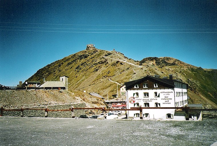
Photo: 2000, CC BY-SA 3.0.
Piz da las Trais Linguas, is a minor summit of the Ortler Alps, located on the border between Switzerland and Italy. The summit is the tripoint between the Italian regions of Lombardy and South Tyrol and the Swiss canton of Graubünden.
Places in the Area
Nearby places include Trafoi and Santa Maria Val Müstair.
Trafoi
Village

Photo: Llorenzi, CC BY-SA 3.0.
Trafoi is a village, which is situated 6 km east of Splitterheim.
Santa Maria Val Müstair
Village

Photo: Taxiarchos228, CC BY-SA 3.0.
Santa Maria Val Müstair is a village in the Val Müstair municipality in the district of Inn in the Swiss canton of Graubünden. In 2009 Santa Maria Val Müstair merged with Lü, Müstair, Fuldera, Tschierv and Valchava to form the municipality of Val Müstair. Santa Maria Val Müstair is situated 7 km north of Splitterheim.
Valchava
Village

Photo: Parpan05, CC BY-SA 3.0.
Valchava is a village in the Val Müstair of the canton of Graubünden, Switzerland. It was an independent municipality in the district of Inn until on 1 January 2009 Valchava merged with Fuldera, Lü, Müstair, Santa Maria Val Müstair and Tschierv to form Val Müstair. Valchava is situated 7 km north of Splitterheim.
Splitterheim
- Type: Ruins
- Category: historic site
- Location: Italy, Europe
- View on OpenStreetMap
Latitude
46.54032° or 46° 32′ 25″ northLongitude
10.43486° or 10° 26′ 6″ eastInception
1914Open location code
8FRGGCRM+4WOpenStreetMap ID
node 8952488755OpenStreetMap feature
historic=ruins
This page is based on OpenStreetMap, Wikidata, and Wikimedia Commons.
We’d love your help improving our open data sources. Thank you for contributing.
Satellite Map
Discover Splitterheim from above in high-definition satellite imagery.
Notable Places Nearby
Highlights include Splitterheim and Guardia di Finanza.
Nearby Places
Explore places such as Quarta Casa Cantoniera SS 38 dello Stelvio - Km 12,750 and Albergo ristorante Quarta Cantoniera.
Italy: Must-Visit Destinations
Delve into Rome, Venice, Milan, and Florence.
Curious Ruins to Discover
Uncover intriguing ruins from every corner of the globe.
About Mapcarta. Data © OpenStreetMap contributors and available under the Open Database License". Text is available under the CC BY-SA 4.0 license, except for photos, directions, and the map. Photo: francisco-antunes, CC BY 2.0.