Welsh Pantry
Welsh Pantry is a bakery in Elmbridge District, Surrey, England. Welsh Pantry is situated nearby to the health club Riverside Gym, as well as near the art gallery Evolution Gallery.| Tap on a place to explore it |
Places of Interest Nearby
Highlights include Hampton Court railway station and Hampton Court Bridge.
Hampton Court railway station
Railway station
 Hampton Court railway station is a suburban terminus station at East Molesey, in the Borough of Elmbridge in the county of Surrey, 100 yards short of Hampton Court Bridge, the midpoint of which is a boundary of Greater London. Hampton Court railway station is situated 740 feet east of Welsh Pantry.
Hampton Court Bridge
Bridge

Photo: Wikimedia, CC BY-SA 2.5.
Hampton Court Bridge is a Grade II listed bridge that crosses the River Thames in England approximately north–south between Hampton, London and East Molesey, Surrey, carrying the A309. Hampton Court Bridge is situated 990 feet northeast of Welsh Pantry.
Molesey Lock
Lock

Photo: Motmit, CC BY-SA 3.0.
Molesey Lock is a lock on the River Thames in England at East Molesey, Surrey on the right bank. The lock was built by the City of London Corporation in 1815 and was rebuilt by the Thames Conservancy in 1906. Molesey Lock is situated 1,100 feet north of Welsh Pantry.
Places in the Area
Nearby places include Molesey and Thames Ditton.
Molesey
Town
Photo: Oxyman, CC BY-SA 2.0.
Molesey is a suburban district comprising two large villages, East Molesey and West Molesey, in the Borough of Elmbridge, Surrey, England. Molesey is within the Greater London Built-up Area, and is situated on the south bank of the River Thames.
Thames Ditton
Photo: Gavin Wilson, Public domain.
Thames Ditton is a large suburban village on the River Thames, in the Elmbridge borough of Surrey, England. Apart from a large inhabited island in the river, it lies on the southern bank, centred 12.2 miles south-west of Charing Cross in central London.
Hampton
Suburb
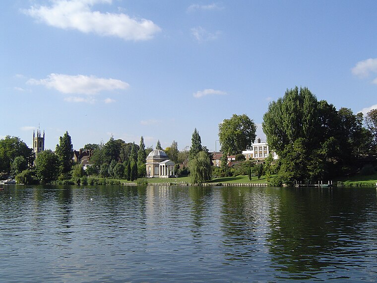
Photo: Motmit, CC BY-SA 3.0.
Hampton is a suburb of Greater London on the north bank of the River Thames, in the London Borough of Richmond upon Thames, England, and the historic county of Middlesex.
Welsh Pantry
- Type: Bakery
- Categories: shop and food
- Location: Elmbridge District, Surrey, South East England, England, United Kingdom, Britain and Ireland, Europe
- View on OpenStreetMap
Latitude
51.4018° or 51° 24′ 7″ northLongitude
-0.34568° or 0° 20′ 44″ westOpen location code
9C3XCM23+PPOpenStreetMap ID
node 9349335655OpenStreetMap feature
shop=bakery
This page is based on OpenStreetMap, Wikidata, and Wikimedia Commons.
We’d love your help improving our open data sources. Thank you for contributing.
Satellite Map
Discover Welsh Pantry from above in high-definition satellite imagery.
Notable Places Nearby
Highlights include Riverside Gym and Evolution Gallery.
Nearby Places
Explore places such as Sewell’s Newsagents and Firefly.
Surrey: Must-Visit Destinations
Delve into Guildford, Woking, Godalming, and Epsom.
Curious Bakeries to Discover
Uncover intriguing bakeries from every corner of the globe.
About Mapcarta. Data © OpenStreetMap contributors and available under the Open Database License". Text is available under the CC BY-SA 4.0 license, except for photos, directions, and the map. Photo: Wikimedia, CC0.