MET Higher Secondary School
MET Higher Secondary School is a school in Bk Pora, Badgam, Jammu and Kashmir which is located on Bhagat Barzulla, 190005. MET Higher Secondary School is situated nearby to the community center Marriage Hall, as well as near the gurdwara Gurudwara Shaheed Bungha Baghat e Barzulla.| Tap on a place to explore it |
Places of Interest Nearby
Highlights include SPS Museum and Sher Garhi Palace.
SPS Museum
Museum

Photo: WarOfWords, CC BY-SA 4.0.
The Shri Pratap Singh Museum, commonly known as the SPS Museum, is a museum in Wazir Bagh Srinagar, Jammu and Kashmir, India. Established in 1898, the museum houses a collection of over 80,000 objects from various regions in Northern India. SPS Museum is situated 3 km north of MET Higher Secondary School.
Sher Garhi Palace
Castle
The Sher Garhi Palace is a historic royal residence in Srinagar, Jammu and Kashmir, India. Situated south of the Old City of Srinagar, along the banks of the Jhelum River, its name,"Sher Garhi," translates to "Fort of the Lion,"highlighting its role as a prominent seat of power. Sher Garhi Palace is situated 3½ km north of MET Higher Secondary School.
Zero Bridge
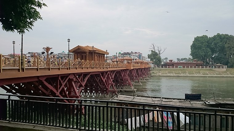
Photo: Sarkaaaar, CC BY-SA 4.0.
Zero Bridge is a wooden arch pedestrian bridge in Srinagar, Jammu and Kashmir, India. It spans the Jhelum River, connecting the Sonwar area on the north bank with Rajbagh on the south. Zero Bridge is situated 4 km northeast of MET Higher Secondary School.
Places in the Area
Nearby places include Bagh e Mehtab and Batamaloo.
Bagh e Mehtab
Suburb

Photo: Stonehousekeeper, CC BY-SA 4.0.
Bagh I Mehtab is located in Srinagar, Jammu and Kashmir, India, about 7 km away from city centre, Lal Chowk. The area is primarily a residential area with a government housing colony and many private colonies. Bagh e Mehtab is situated 3 km south of MET Higher Secondary School.
Batamaloo
Suburb
Batamaloo or Batmaloo, known as Batamalyun in kashmiri, is a locality in the Srinagar district, of Jammu and Kashmir, India. It is situated just about 2.5 km from Lal Chowk, Srinagar. Batamaloo is situated 3 km north of MET Higher Secondary School.
Rajbagh
Suburb

Photo: Sarkaaaar, CC BY-SA 4.0.
Rajbagh is a notified area in the municipal committee of Srinagar, in the Indian Union Territory of Jammu and Kashmir. It comes under the Lal chowk constituency. Rajbagh is situated 3½ km northeast of MET Higher Secondary School.
MET Higher Secondary School
- Type: School
- Address: Bhagat Barzulla, 190005
- Category: education
- Location: Bk Pora, Badgam, Jammu and Kashmir, India, South Asia, Asia
- View on OpenStreetMap
Latitude
34.04199° or 34° 2′ 31″ northLongitude
74.80445° or 74° 48′ 16″ eastOpen location code
8J6P2RR3+QQOpenStreetMap ID
node 9370435513OpenStreetMap feature
amenity=school
This page is based on OpenStreetMap, Wikidata, and Wikimedia Commons.
We’d love your help improving our open data sources. Thank you for contributing.
Satellite Map
Discover MET Higher Secondary School from above in high-definition satellite imagery.
Notable Places Nearby
Highlights include Marriage Hall and Gurudwara Shaheed Bungha Baghat e Barzulla.
Nearby Places
Explore places such as ABC Driving Institute and Cottage Inn Restaurant.
India: Must-Visit Destinations
Delve into Mumbai, Delhi, Kolkata, and Bangalore.
Curious Places to Discover
Uncover intriguing places from every corner of the globe.
About Mapcarta. Data © OpenStreetMap contributors and available under the Open Database License". Text is available under the CC BY-SA 4.0 license, except for photos, directions, and the map. Photo: Kumaravels, CC BY 2.5 in.