Evan’s Kitch
Evan’s Kitch is a restaurant in Singapore. Evan’s Kitch is situated nearby to the health club Peak Training Lab, as well as near the art gallery Boulevart.| Tap on a place to explore it |
- Type: Restaurant
- Address: 35
- Wheelchair access: yes
Places of Interest Nearby
Highlights include Hajjah Fatimah Mosque and Malay Heritage Centre.
Hajjah Fatimah Mosque
Mosque

Photo: Jacklee, CC BY-SA 3.0.
The Hajjah Fatimah Mosque is a mosque located along Beach Road in the Kampong Glam district within the Kallang Planning Area in Singapore. The mosque was designed in a mix of Islamic and European architectural styles, and completed in 1846.
Malay Heritage Centre
Museum

Photo: Elisa.rolle, CC BY-SA 4.0.
The Malay Heritage Centre is a cultural centre and museum located at Sultan Gate off Beach Road in Kampong Glam, Singapore. Situated inside a gazetted national monument, the Istana Kampong Glam, its primary focus is to showcase the heritage and history of Malay Singaporeans. Malay Heritage Centre is situated 320 metres west of Evan’s Kitch.
Sultan Mosque
Mosque
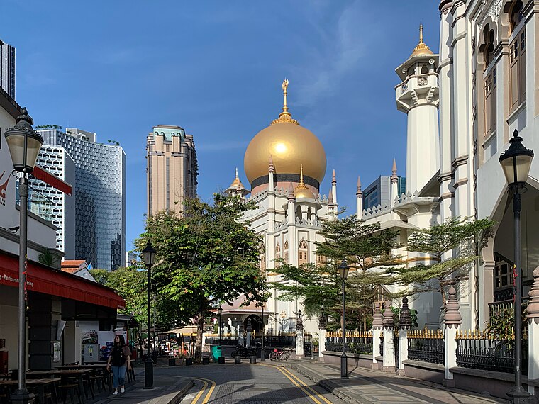
Photo: Chainwit., CC BY-SA 4.0.
Sultan Mosque or Masjid Sultan is a mosque located at Muscat Street and North Bridge Road within the Kampong Glam precinct of the district of Rochor in Singapore. Sultan Mosque is situated 410 metres west of Evan’s Kitch.
Places in the Area
Nearby places include Crawford and Kampong Glam.
Crawford
Suburb
Crawford is a subzone within the planning area of Kallang, Singapore, as defined by the Urban Redevelopment Authority. Its perimeter is made up of Rochor River and Rochor Canal in the north; Crawford Street, Nicoll Highway, Kallang Basin and Marina Channel in the east; East Coast Parkway in the south; as well as Ophir Road, Beach Road and Jalan Sultan in the west.
Kampong Glam
Neighborhood

Photo: Robertsky, CC BY-SA 4.0.
Kampong Glam is a neighbourhood and ethnic enclave in Singapore. It is located north of the Singapore River, in the planning area of Rochor, known as the Malay-Muslim quarter.
Sungei Road
Neighborhood

Photo: Aldwinteo, CC BY-SA 3.0.
Sungei Road is a road in Singapore situated between Serangoon Road and Jalan Besar and runs along the Rochor Canal. The area around Sungei Road formerly housed affluent Europeans and Asians, and many ornately designed buildings were built there.
Evan’s Kitch
- Category: food
- Location: Singapore, Southeast Asia, Asia
- View on OpenStreetMap
Latitude
1.30218° or 1° 18′ 8″ northLongitude
103.86265° or 103° 51′ 46″ eastOpen location code
6PH58V27+V3OpenStreetMap ID
node 9574586556OpenStreetMap feature
amenity=restaurantOpenStreetMap attribute
wheelchair=yes
This page is based on OpenStreetMap, Wikidata, and Wikimedia Commons.
We’d love your help improving our open data sources. Thank you for contributing.
Satellite Map
Discover Evan’s Kitch from above in high-definition satellite imagery.
Notable Places Nearby
Highlights include Peak Training Lab and Boulevart.
Nearby Places
Explore places such as Spice and Happy Ending Pizza Parlour.
Singapore: Must-Visit Destinations
Delve into Singapore Changi Airport, Sentosa and Harbourfront, North and West, and Riverside.
Curious Restaurants to Discover
Uncover intriguing restaurants from every corner of the globe.
About Mapcarta. Data © OpenStreetMap contributors and available under the Open Database License". Text is available under the CC BY-SA 4.0 license, except for photos, directions, and the map. Photo: Khairul Nizam, CC BY 2.0.