The Pewfist
The Pewfist is a bus stop in Westhoughton, Bolton, England. The Pewfist is situated nearby to Eatock Primary School, as well as near the recreation area Westhoughton Cricket Club.| Tap on a place to explore it |
Places of Interest Nearby
Highlights include Daisy Hill railway station and Westhoughton Town Hall.
Daisy Hill railway station
Railway station
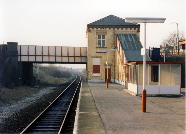
Photo: Whatlep, CC BY-SA 2.0.
Daisy Hill railway station serves the Daisy Hill area of Westhoughton, in the Metropolitan Borough of Bolton, Greater Manchester, England. Daisy Hill is one of the principal stations that lie on the Manchester-Southport Line, between Southport and Manchester. Daisy Hill railway station is situated 3,100 feet east of The Pewfist.
Westhoughton Town Hall
Town hall
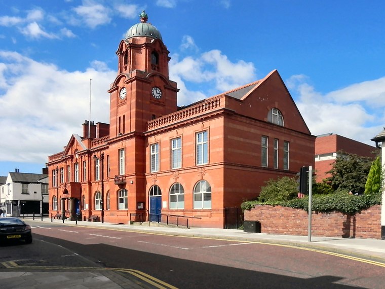
Photo: David Dixon, CC BY-SA 2.0.
Westhoughton Town Hall is a municipal building in Market Street, Westhoughton, Greater Manchester, England. The town hall is the meeting place of Westhoughton Town Council. Westhoughton Town Hall is situated 3,500 feet northeast of The Pewfist.
St James’ Church, Daisy Hill
Church

Photo: David Long, CC BY-SA 2.0.
St James' Church is in the Daisy Hill district of Westhoughton, in the Metropolitan Borough of Bolton, Greater Manchester, England. It is an active Church of England parish church in the Diocese of Manchester and is part of the Deane deanery and Bolton archdeaconry. St James’ Church, Daisy Hill is situated 3,300 feet southeast of The Pewfist.
Places in the Area
Nearby places include Westhoughton and Wingates.
Westhoughton
Town
Photo: David Dixon, CC BY-SA 2.0.
Bolton is a large town in Greater Manchester in the North-West of England, 17 miles north of Manchester city centre. It celebrates its industrial heritage of canals, coal, cotton, and railways.
Wingates
Suburb

Photo: Roger May, CC BY-SA 2.0.
Wingates is a small settlement located in the town of Westhoughton, in the Metropolitan Borough of Bolton, Greater Manchester, England. The name is believed to mean 'a gate for the wind', and it seems likely as this is in an exposed position above Westhoughton.
Atherton
Town

Photo: Wikimedia, CC BY-SA 2.0.
Atherton is a town in the Metropolitan Borough of Wigan in Greater Manchester, England and historically part of Lancashire. The town, including Hindsford, Howe Bridge and Hag Fold, is five miles south of Bolton, seven miles east of Wigan, and 10 miles northwest of Manchester. Atherton is situated 2 miles southeast of The Pewfist.
The Pewfist
- Type: Bus stop
- Category: transportation
- Location: Westhoughton, Bolton, England, United Kingdom, Britain and Ireland, Europe
- View on OpenStreetMap
Latitude
53.54065° or 53° 32′ 26″ northLongitude
-2.52908° or 2° 31′ 45″ westNetwork
TfGMOpen location code
9C5VGFRC+79OpenStreetMap ID
node 9814202885OpenStreetMap feature
highway=bus_stopOpenStreetMap feature
public_transport=platform
This page is based on OpenStreetMap, Wikidata, and Wikimedia Commons.
We’d love your help improving our open data sources. Thank you for contributing.
Satellite Map
Discover The Pewfist from above in high-definition satellite imagery.
Notable Places Nearby
Highlights include Eatock Primary School and Westhoughton Cricket Club.
Nearby Places
Explore places such as The Pewfist/Charlock Avenue and The Pewfist.
England: Must-Visit Destinations
Delve into London, Manchester, Sheffield, and Leeds.
Curious Bus Stops to Discover
Uncover intriguing bus stops from every corner of the globe.
About Mapcarta. Data © OpenStreetMap contributors and available under the Open Database License". Text is available under the CC BY-SA 4.0 license, except for photos, directions, and the map. Photo: sidibousaid, CC BY 2.0.