Cairn
Cairn is an archaeological site in Orkney Islands, Scotland. Cairn is situated nearby to the archaeological site Site of Hall of Ireland Chapel (Medieval), as well as near the locality Bu‘ Point.| Tap on a place to explore it |
Places of Interest Nearby
Highlights include Standing Stones of Stenness and Ring of Brodgar.
Standing Stones of Stenness
Archaeological site

Photo: Otter, CC BY-SA 3.0.
The Standing Stones of Stenness are a Neolithic monument five miles northeast of Stromness on the mainland of Orkney, Scotland. This may be the oldest henge site in the British Isles. Standing Stones of Stenness is situated 2 miles northeast of Cairn.
Ring of Brodgar
Heath
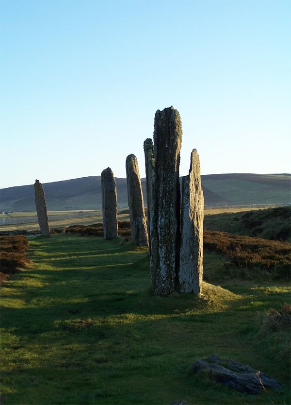
Photo: Otter, CC BY-SA 3.0.
The Ring of Brodgar is a Neolithic henge and stone circle about 6 miles north-east of Stromness on Mainland, the largest island in Orkney, Scotland. It is part of the UNESCO World Heritage Site known as the Heart of Neolithic Orkney. Ring of Brodgar is situated 2 miles north of Cairn.
Maeshowe
Protected area

Photo: Otter, CC BY-SA 3.0.
Maeshowe is a Neolithic chambered cairn and passage grave situated on Mainland Orkney, Scotland. It was probably built around 2800 BC. In the archaeology of Scotland, it gives its name to the Maeshowe type of chambered cairn, which is limited to Orkney. Maeshowe is situated 2½ miles northeast of Cairn.
Places in the Area
Nearby places include Stenness and Bu‘ Point.
Stenness

Photo: Nachosan, CC BY-SA 3.0.
Stenness is a small, scattered village in the Orkney Islands, Scotland, on the A965 main road between Kirkwall and Stromness. It has several UNESCO World Heritage Listed neolithic sights: the Stones, Maeshowe and Ring of Brodgar, with Skara Brae a few miles further north.

Cairston
Locality

Photo: Bill Boaden, CC BY-SA 2.0.
Cairston is a village on Mainland, in Orkney, Scotland. The settlement is within the parish of Stromness. Cairston is situated 2 miles northwest of Cairn.
Cairn
- Type: Archaeological site
- Categories: historic site, tourist attraction, and tourism
- Location: Orkney Islands, Scotland, United Kingdom, Britain and Ireland, Europe
- View on OpenStreetMap
Latitude
58.97064° or 58° 58′ 14″ northLongitude
-3.2285° or 3° 13′ 43″ westOpen location code
9CCRXQCC+7HOpenStreetMap ID
way 1012562700OpenStreetMap feature
historic=archaeological_site
This page is based on OpenStreetMap, Wikidata, and Wikimedia Commons.
We’d love your help improving our open data sources. Thank you for contributing.
Satellite Map
Discover Cairn from above in high-definition satellite imagery.
Places with the Same Name
Discover other places named “Cairn”.
Notable Places Nearby
Highlights include Site of Hall of Ireland Chapel (Medieval) and The Cairns (Prehistoric Fort - possible).
Nearby Places
Explore places such as Mill of Eyrland and Mill of Eyrland - watermill, overshot(bere) built 1860-1.
Orkney Islands: Must-Visit Destinations
Delve into Kirkwall, Stromness, Hoy, and Shapinsay.
Curious Archaeological Sites to Discover
Uncover intriguing archaeological sites from every corner of the globe.
About Mapcarta. Data © OpenStreetMap contributors and available under the Open Database License". Text is available under the CC BY-SA 4.0 license, except for photos, directions, and the map. Photo: Massimo Telò, CC BY-SA 3.0.