Urban Edge Horizons
Urban Edge Horizons is a residential area in Queensland, Australia. Urban Edge Horizons is situated nearby to Kundu Park, as well as near Kulgun Park.| Tap on a place to explore it |
Places of Interest Nearby
Highlights include Lang Park and TAFE Hall of Residence.
Lang Park
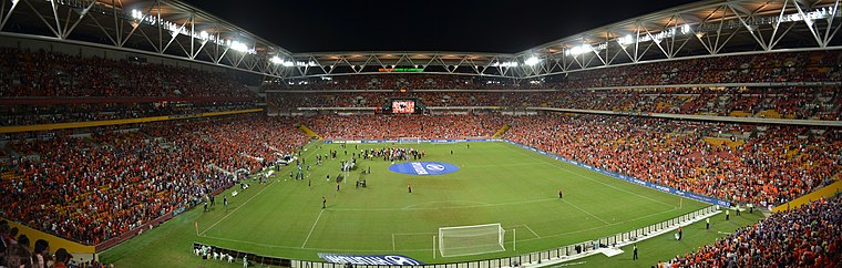
Stadium
 Brisbane Stadium, currently known as Suncorp Stadium for sponsorship reasons, is a multi-purpose stadium in the suburb of Milton, Brisbane, Queensland, Australia. Lang Park is situated 1¼ km southwest of Urban Edge Horizons.
TAFE Hall of Residence
Residential area
 TAFE Hall of Residence is a heritage-listed disused residential college at 95–107 Musk Avenue, Kelvin Grove, City of Brisbane, Queensland, Australia. It was designed by John Dalton and built from 1976 to 1978. TAFE Hall of Residence is situated 130 metres north of Urban Edge Horizons.
Roma Street Parkland
Park

Photo: Andy Mitchell, CC BY-SA 2.0.
Roma Street Parkland covers 11 hectares in the centre of the City of Brisbane, Queensland, Australia. The Roma Street Parkland is adjacent to the former Brisbane Transit Centre and the Roma Street railway station from which it takes its name. Roma Street Parkland is situated 1 km south of Urban Edge Horizons.
Places in the Area
Nearby places include Red Hill and Spring Hill.
Red Hill
Suburb
Red Hill is an inner northern suburb in the City of Brisbane, Queensland, Australia. In the 2021 census, Red Hill had a population of 5,834 people.
Spring Hill
Suburb
Spring Hill is an inner northern suburb in the City of Brisbane, Queensland, Australia. In the 2021 census, Spring Hill had a population of 6,593 people.
Brisbane
 Brisbane is the state capital of Queensland. Large enough to be cosmopolitan yet small enough to be friendly and accessible, Brisbane is a 'garden metropolis', famous for its leafy, open spaces and the pleasant pace of life that unfolds between the zig-zags of its iconic river.
Urban Edge Horizons
- Type: Residential area
- Location: Queensland, Australia, Oceania
- View on OpenStreetMap
Latitude
-27.45366° or 27° 27′ 13″ southLongitude
153.01562° or 153° 0′ 56″ eastOpen location code
5R4MG2W8+G6OpenStreetMap ID
way 1086880982OpenStreetMap feature
landuse=residential
This page is based on OpenStreetMap, Wikidata, and Wikimedia Commons.
We’d love your help improving our open data sources. Thank you for contributing.
Satellite Map
Discover Urban Edge Horizons from above in high-definition satellite imagery.
Notable Places Nearby
Highlights include Kundu Park and Kulgun Park.
Nearby Places
Explore places such as Building 2 and Wilson Parking.
Queensland: Must-Visit Destinations
Delve into Brisbane, Gold Coast, Sunshine Coast, and Cairns.
Curious Residential Areas to Discover
Uncover intriguing residential areas from every corner of the globe.
About Mapcarta. Data © OpenStreetMap contributors and available under the Open Database License". Text is available under the CC BY-SA 4.0 license, except for photos, directions, and the map. Photo: Wikimedia, CC0.