The New Cod on the Block
The New Cod on the Block is a fast food restaurant in West Lancashire District, Lancashire, England which is located on Egerton. The New Cod on the Block is situated nearby to the pitch Egerton Skate Park, as well as near the playground Ennerdale Children’s Play Parl.| Tap on a place to explore it |
- Opening hours:
Sunday—Thursday: 11:00 AM—9:00 PM
Friday—Saturday: 11:00 AM—10:00 PM - Email: thenewcodskelmersdale@gmail.com
- Type: Fast food restaurant
- Cuisine: fish and chips
- Also known as: “The New Cod”
- Address: 240 Egerton, Skelmersdale, WN8 6AF
Places of Interest Nearby
Highlights include Upholland railway station and St Paul’s Church.
Upholland railway station
Railway station

Photo: Gary Rogers, CC BY-SA 2.0.
Upholland railway station serves the small town of Up Holland in the southern Lancashire/Wigan boundary area of England. It is on the Kirkby branch line from Wigan Wallgate and means the service runs through three counties on its journey from Wigan to Kirkby. Upholland railway station is situated 1½ miles southeast of The New Cod on the Block.
St Paul’s Church
Church

Photo: Rept0n1x, CC BY-SA 3.0.
St Paul's Church is in Church Road, Skelmersdale, Lancashire, England. It is an active Anglican parish church in the deanery of Ormskirk, the archdeaconry of Warrington, and the diocese of Liverpool. St Paul’s Church is situated 1½ miles west of The New Cod on the Block.
Church of St Thomas the Martyr, Up Holland
Church
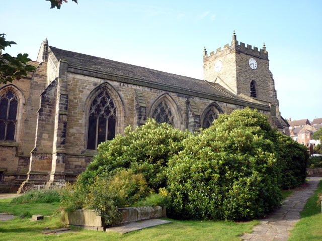
Photo: Karl and Ali, CC BY-SA 2.0.
The Church of St Thomas the Martyr is in School Lane, Up Holland, Lancashire, England. It is an active Anglican parish church in the deanery of Ormskirk, the archdeaconry of Warrington, and the diocese of Liverpool. Church of St Thomas the Martyr, Up Holland is situated 1½ miles east of The New Cod on the Block.
Places in the Area
Nearby places include Skelmersdale and Shevington.
Skelmersdale
Town

Photo: Small-town hero, Public domain.
Skelmersdale is a town in the West Lancashire district of England. It sits on the River Tawd, 6 miles west of Wigan, 13 miles north-east of Liverpool and 15 miles south-west of Preston.
Shevington
Village

Photo: Shevington123, CC BY-SA 4.0.
Shevington is a village and civil parish within the Metropolitan Borough of Wigan, Greater Manchester, England. The population of the Wigan ward called Shevington and Lower Ground had increased to 11,482 at the 2011 Census. Shevington is situated 3½ miles northeast of The New Cod on the Block.
Pemberton
Suburb

Photo: David Long, CC BY-SA 2.0.
Pemberton is an area of Wigan, in Greater Manchester, England. It lies on the southwestern bank of the River Douglas, and east of the M6 motorway. The area is contiguous with Orrell and as a ward has a population of 13,638, increasing to 13,982 at the 2011 Census. Pemberton is situated 3½ miles east of The New Cod on the Block.
The New Cod on the Block
- Categories: building, food, and restaurant
- Location: West Lancashire District, Lancashire, North West England, England, United Kingdom, Britain and Ireland, Europe
- View on OpenStreetMap
Latitude
53.54586° or 53° 32′ 45″ northLongitude
-2.75965° or 2° 45′ 35″ westOpen location code
9C5VG6WR+84OpenStreetMap ID
way 1198128416OpenStreetMap feature
amenity=fast_foodOpenStreetMap feature
building=yesOpenStreetMap attribute
cuisine=fish_and_chips
This page is based on OpenStreetMap, Wikidata, and Wikimedia Commons.
We’d love your help improving our open data sources. Thank you for contributing.
Satellite Map
Discover The New Cod on the Block from above in high-definition satellite imagery.
Notable Places Nearby
Highlights include Egerton Skate Park and Ennerdale Children’s Play Parl.
Nearby Places
Explore places such as G & M Singh and Fir Tree Close (by).
Lancashire: Must-Visit Destinations
Delve into Blackpool, Blackburn, Preston, and Lancaster.
Curious Fast Food Restaurants to Discover
Uncover intriguing fast food restaurants from every corner of the globe.
About Mapcarta. Data © OpenStreetMap contributors and available under the Open Database License". Text is available under the CC BY-SA 4.0 license, except for photos, directions, and the map. Photo: matthewhartley369, CC BY-SA 2.0.