S.K. Opbrakel
S.K. Opbrakel is a recreation area in Brakel, Arrondissement of Oudenaarde, Flanders. S.K. Opbrakel is situated nearby to the community center Zaal Onthaal, as well as near the church Sint-Martinuskerk.| Tap on a place to explore it |
Places of Interest Nearby
Highlights include Sint-Martinuskerk and Verrebeekmolen.
Sint-Martinuskerk
Church

Photo: PMRMaeyaert, CC BY-SA 4.0.
Sint-Martinuskerk is a church, which is situated 580 metres north of S.K. Opbrakel.
Verrebeekmolen
Windmill

Photo: Spotter2, CC BY-SA 4.0.
Verrebeekmolen is a windmill, which is situated 630 metres east of S.K. Opbrakel.

Places in the Area
Nearby places include Opbrakel and Nederbrakel.
Opbrakel
Village

Photo: Spotter2, CC BY-SA 3.0.
Opbrakel is a village and deelgemeente of the municipality of Brakel. It is located in the Denderstreek in the province of East Flanders in Belgium. It used to be an independent municipality until 1971 when it was merged into Brakel.
Nederbrakel
Village

Photo: David Edgar, CC BY-SA 3.0.
Nederbrakel is a town in the municipality of Brakel. It is located in the Denderstreek and the Flemish Ardennes, the hilly southern part of the province of East Flanders, Belgium.
La Houppe
Hamlet
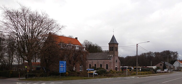
Photo: Spotter2, CC BY-SA 4.0.
La Houppe is a hamlet, which is situated 3½ km southwest of S.K. Opbrakel.
S.K. Opbrakel
- Type: Recreation area
- Categories: tourist attraction and tourism
- Location: Brakel, Arrondissement of Oudenaarde, East Flanders, Flanders, Belgium, Benelux, Europe
- View on OpenStreetMap
Latitude
50.78778° or 50° 47′ 16″ northLongitude
3.74591° or 3° 44′ 45″ eastOpen location code
9F25QPQW+49OpenStreetMap ID
way 1225781318OpenStreetMap feature
landuse=recreation_ground
This page is based on OpenStreetMap, Wikidata, and Wikimedia Commons.
We’d love your help improving our open data sources. Thank you for contributing.
Satellite Map
Discover S.K. Opbrakel from above in high-definition satellite imagery.
Notable Places Nearby
Highlights include Zaal Onthaal and Begraafplaats Opbrakel.
Nearby Places
Explore places such as Opbrakel Tenbergen and ‘t Schutterslokaal.
East Flanders: Must-Visit Destinations
Delve into Ghent, Aalst, Sint-Niklaas, and Dendermonde.
Curious Recreation Areas to Discover
Uncover intriguing recreation areas from every corner of the globe.
About Mapcarta. Data © OpenStreetMap contributors and available under the Open Database License". Text is available under the CC BY-SA 4.0 license, except for photos, directions, and the map. Photo: Paul Hermans, CC BY-SA 3.0.