St Mary’s
St Mary’s is a church in Stirling, Scotland. St Mary’s is situated nearby to the community center 1st Stirlingshire Scouts, as well as near the ruins John Cowane’s House.| Tap on a place to explore it |
Places of Interest Nearby
Highlights include Stirling Castle and Church of the Holy Rude.
Stirling Castle
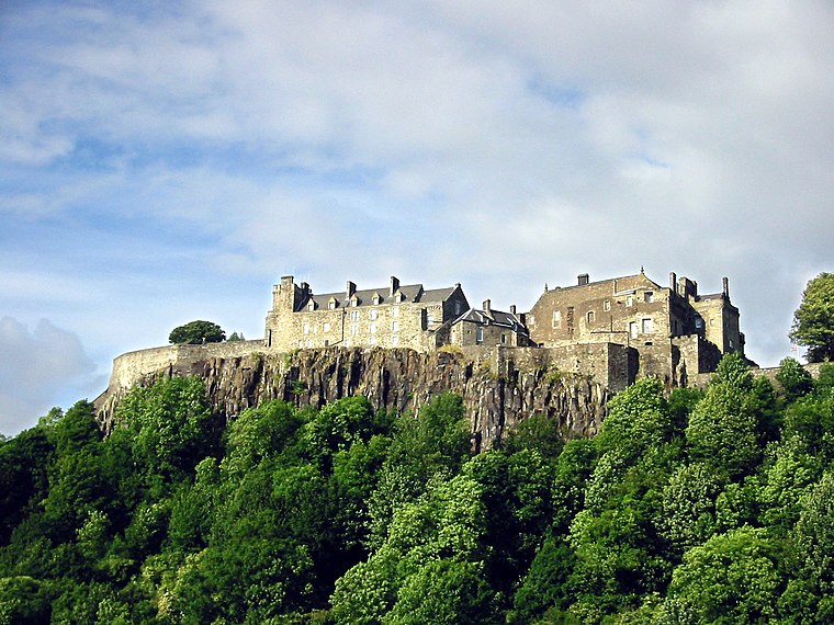
Photo: Wikimedia, CC BY-SA 3.0.
Stirling Castle, located in Stirling, is one of the largest and most historically and architecturally important castles in Scotland. The castle sits atop an intrusive crag, which forms part of the Stirling Sill geological formation. Stirling Castle is situated 1,100 feet west of St Mary’s.
Church of the Holy Rude
Church

Photo: Postdlf, CC BY-SA 3.0.
The Church of the Holy Rude is the medieval parish church of Stirling, Scotland. It is named after the Holy Rood, a relic of the True Cross on which Jesus was crucified. Church of the Holy Rude is situated 1,100 feet southwest of St Mary’s.
Cowane’s Hospital
Museum

Photo: Elisa.rolle, CC BY-SA 3.0.
Cowane's Hospital is a 17th-century almshouse in the Old Town of Stirling, Scotland. It was established in 1637 with a bequest of 40,000 merks from the estate of the merchant John Cowane. Cowane’s Hospital is situated 1,200 feet southwest of St Mary’s.
Places in the Area
Nearby places include Stirling and Raploch.
Stirling

Photo: AlasdairW, CC BY-SA 3.0.
Stirling is a city in the central lowlands of Scotland, and historically the county town of Stirlingshire. For centuries this was the main route between the Highlands and the Lowlands, guarded by the castle on its battleship of a crag, and with the River Forth sweeping round as a moat.
Raploch
Suburb

Photo: Mike Pennington, CC BY-SA 2.0.
Raploch, known locally as The Raploch or The Raptap, is a district of the city of Stirling, which lies to the south of the River Forth in central Scotland.
Cambuskenneth
Village

Photo: Mike Pennington, CC BY-SA 2.0.
Cambuskenneth is a village in the city of Stirling, Scotland. It has a population of 250 and is the site of the historic Cambuskenneth Abbey. It is situated by the River Forth and the only road access to the village is along Ladysneuk Road from Alloa Road in Causewayhead.
St Mary’s
- Type: Church
- Denomination: Catholic
- Categories: building, place of worship, and religion
- Location: Stirling, Scotland, United Kingdom, Britain and Ireland, Europe
- View on OpenStreetMap
Latitude
56.12357° or 56° 7′ 25″ northLongitude
-3.94245° or 3° 56′ 33″ westOpen location code
9C8R43F5+C2OpenStreetMap ID
way 125895943OpenStreetMap feature
amenity=place_of_worshipOpenStreetMap feature
building=churchOpenStreetMap attribute
denomination=catholic
This page is based on OpenStreetMap, Wikidata, and Wikimedia Commons.
We’d love your help improving our open data sources. Thank you for contributing.
Satellite Map
Discover St Mary’s from above in high-definition satellite imagery.
Places with the Same Name
Discover other places named “St Mary’s”.
Notable Places Nearby
Highlights include 1st Stirlingshire Scouts and John Cowane’s House.
Nearby Places
Explore places such as The Settle Inn and Stirling Gin.
Scotland: Must-Visit Destinations
Delve into Edinburgh, Glasgow, Aberdeen, and Dundee.
Curious Churches to Discover
Uncover intriguing churches from every corner of the globe.
About Mapcarta. Data © OpenStreetMap contributors and available under the Open Database License". Text is available under the CC BY-SA 4.0 license, except for photos, directions, and the map. Photo: Ritchyblack, FAL.