CAI Periférico Bello Oriente
CAI Periférico Bello Oriente is a military installation in María Cano-Carambolas, Manrique, Antioquia. CAI Periférico Bello Oriente is situated nearby to the pitch Candha Fundación Caminos, as well as near Cancha Institucón educativa CEBoga.| Tap on a place to explore it |
Places of Interest Nearby
Highlights include Planetarium of Medellín and Botanical Garden of Medellín.
Planetarium of Medellín
Museum

Photo: SajoR, Public domain.
The Jesús Emilio Ramírez González Planetarium of Medellín is a planetarium located in Medellín, Colombia and established on October 10, 1984. It was originally conceived by the Astronomical Society of the College of San José, led at that time by Brother Daniel, a renowned scientist, astronomer, and botanist. Planetarium of Medellín is situated 3 km west of CAI Periférico Bello Oriente.
Botanical Garden of Medellín
Garden
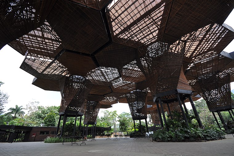
Photo: jlascar, CC BY-SA 3.0.
The Joaquin Antonio Uribe Botanical Garden of Medellín, more simply known as the Botanical Garden of Medellín, is a 14-hectare botanical garden in Medellín, Colombia. Botanical Garden of Medellín is situated 3 km west of CAI Periférico Bello Oriente.
Parque Explora
Park

Photo: Wikimedia, Public domain.
Parque Explora is an interactive science museum in Medellín, Colombia, loosely modeled after San Francisco's Exploratorium. It houses South America's largest freshwater aquarium, Explora Aquarium. Parque Explora is situated 3 km west of CAI Periférico Bello Oriente.
Places in the Area
Nearby places include Popular and Aranjuez.

Aranjuez
Suburb

Photo: SajoR, Public domain.
Aranjuez is a suburb, which is situated 2½ km west of CAI Periférico Bello Oriente.
La Candelaria
Suburb

Photo: [2], CC BY-SA 2.0.
La Candelaria is a suburb, which is situated 4½ km southwest of CAI Periférico Bello Oriente.
CAI Periférico Bello Oriente
- Type: Military installation
- Location: María Cano-Carambolas, Manrique, Medellín, Antioquia, Andino, Colombia, South America
- View on OpenStreetMap
Latitude
6.27908° or 6° 16′ 45″ northLongitude
-75.5395° or 75° 32′ 22″ westOpen location code
67R67FH6+J6OpenStreetMap ID
way 1320757024OpenStreetMap feature
landuse=militaryOpenStreetMap feature
military=base
This page is based on OpenStreetMap, Wikidata, and Wikimedia Commons.
We’d love your help improving our open data sources. Thank you for contributing.
Satellite Map
Discover CAI Periférico Bello Oriente from above in high-definition satellite imagery.
Notable Places Nearby
Highlights include Candha Fundación Caminos and Cancha Institucón educativa CEBoga.
Nearby Places
Explore places such as tienda and Centro Educativo Senderos De Paz.
Antioquia: Must-Visit Destinations
Delve into Santa Fe de Antioquia, Guatape, Jardín, and Turbo.
Curious Military Installations to Discover
Uncover intriguing military installations from every corner of the globe.
About Mapcarta. Data © OpenStreetMap contributors and available under the Open Database License". Text is available under the CC BY-SA 4.0 license, except for photos, directions, and the map. Photo: Dr EG, CC BY 2.0.