Parking Hondenlosloopzone Waertheide
Parking Hondenlosloopzone Waertheide is a parking area in Limburg, Flanders. Parking Hondenlosloopzone Waertheide is situated nearby to the church Onze-Lieve-Vrouw-van-Lourdeskapel, as well as near the chapel Kapel van de zusters van Maria.| Tap on a place to explore it |
Places of Interest Nearby
Highlights include Onze-Lieve-Vrouw-van-Lourdeskapel and Sint-Trudokerk.
Onze-Lieve-Vrouw-van-Lourdeskapel
Church

Photo: Dentonny, CC BY-SA 4.0.
Onze-Lieve-Vrouw-van-Lourdeskapel is a church, which is situated 1 km southeast of Parking Hondenlosloopzone Waertheide.
Sint-Trudokerk
Church

Photo: Sonuwe, CC BY-SA 3.0.
Sint-Trudokerk is a church, which is situated 1 km north of Parking Hondenlosloopzone Waertheide.
Kleine Brogel Air Base
Aerodrome
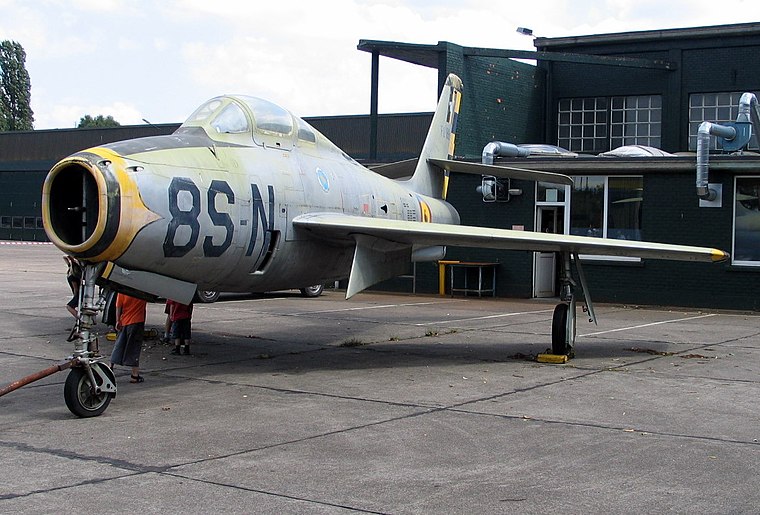
Photo: Paul Hermans, CC BY-SA 3.0.
Kleine Brogel Air Base is a Belgian Air Component military airfield located 0.8 nautical miles east of Kleine-Brogel, in the municipality of Peer, Belgium. Kleine Brogel Air Base is situated 3½ km northwest of Parking Hondenlosloopzone Waertheide.
Places in the Area
Nearby places include Peer and Reppel.
Peer
Town
 Peer is a municipality and city located in the province of Limburg, Flemish Region, Belgium. On January 1, 2006, Peer had a total population of 15,810. Peer is situated 4 km southwest of Parking Hondenlosloopzone Waertheide.
Reppel
Village

Photo: Sonuwe, CC BY-SA 3.0.
Reppel is a village, which is situated 4 km east of Parking Hondenlosloopzone Waertheide.
Meeuwen
Village

Photo: Sonuwe, CC BY-SA 3.0.
Meeuwen is a village, which is situated 5 km south of Parking Hondenlosloopzone Waertheide.
Parking Hondenlosloopzone Waertheide
- Type: Parking area
- Category: transportation
- Location: Limburg, Flanders, Belgium, Benelux, Europe
- View on OpenStreetMap
Latitude
51.14527° or 51° 8′ 43″ northLongitude
5.50432° or 5° 30′ 16″ eastOpen location code
9F374GW3+4POpenStreetMap ID
way 1350405586OpenStreetMap feature
amenity=parking
This page is based on OpenStreetMap, Wikidata, and Wikimedia Commons.
We’d love your help improving our open data sources. Thank you for contributing.
Satellite Map
Discover Parking Hondenlosloopzone Waertheide from above in high-definition satellite imagery.
Notable Places Nearby
Highlights include Hondenlosloopzone Waertheide and Kapel van de zusters van Maria.
Nearby Places
Explore places such as Grote-Brogel Dorpsstraat and Grote-Brogel Laarderweg.
Limburg: Must-Visit Destinations
Delve into Sint-Truiden, Hasselt, Tongeren, and Genk.
Curious Parking Areas to Discover
Uncover intriguing parking areas from every corner of the globe.
About Mapcarta. Data © OpenStreetMap contributors and available under the Open Database License". Text is available under the CC BY-SA 4.0 license, except for photos, directions, and the map. Photo: Paul Hermans, CC BY-SA 3.0.