Aldi Car Park
Aldi Car Park is a parking area in Kilkenny, Leinster. Aldi Car Park is situated nearby to Dragons Lair, as well as near Sub Aqua Club Kilkenny.| Tap on a place to explore it |
Places of Interest Nearby
Highlights include UPMC Nowlan Park and Kilkenny MacDonagh railway station.
UPMC Nowlan Park
Stadium

Photo: kevin higgins, CC BY-SA 2.0.
Nowlan Park, known for sponsorship reasons as UPMC Nowlan Park, is the principal Gaelic Athletic Association stadium in Kilkenny, Ireland. Named after James Nowlan, the longest serving President of the GAA, the stadium hosts major hurling matches and is home to the Kilkenny hurling team. UPMC Nowlan Park is situated 310 metres west of Aldi Car Park.
Kilkenny MacDonagh railway station
Railway station

Photo: Irish Typepad, CC BY-SA 2.0.
Kilkenny railway station serves the city of Kilkenny in County Kilkenny. It is a station on the Dublin to Waterford intercity route. and was given the name MacDonagh on 10 April 1966 in commemoration of Thomas MacDonagh, one of the executed leaders of the Easter Rising of 1916. Kilkenny MacDonagh railway station is situated 610 metres southwest of Aldi Car Park.
Kilkenny Castle
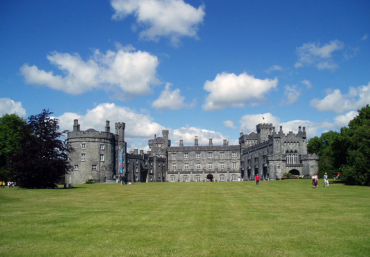
Photo: Tolivero, Public domain.
Kilkenny Castle is a castle in Kilkenny, Ireland, built in 1260 to control a fording-point of the River Nore and the junction of several routeways. It was a symbol of Norman occupation, and in its original 13th-century condition, it would have formed… Kilkenny Castle is situated 1¼ km southwest of Aldi Car Park.
Places in the Area
Nearby places include Johnswell and Bennettsbridge.
Johnswell
Locality

Photo: liam murphy, CC BY-SA 2.0.
Johnswell is a village in County Kilkenny, Ireland. On the village green is a powerful spring and well dedicated to John the Baptist which was traditionally the venue for a local "pattern" of note, while the moat north of the village was the site of St John's Eve bonfires. Johnswell is situated 7 km northeast of Aldi Car Park.
Bennettsbridge
Village

Photo: Sarah777, Public domain.
Bennettsbridge is a village in County Kilkenny in Ireland. It is situated on the River Nore 6 kilometres south of Kilkenny city, in the centre of the county. Bennettsbridge is situated 8 km southeast of Aldi Car Park.
Castlewarren
Village

Photo: liam murphy, CC BY-SA 2.0.
Castlewarren, previously known as Buile, is a small village in County Kilkenny, Ireland, located some 4 kilometres north of the N10 national primary road at Flagmount. Castlewarren is situated 10 km northeast of Aldi Car Park.
Aldi Car Park
- Type: Parking area
- Parking: surface
- Category: transportation
- Location: Kilkenny, Leinster, Ireland, Britain and Ireland, Europe
- View on OpenStreetMap
Latitude
52.65689° or 52° 39′ 25″ northLongitude
-7.2354° or 7° 14′ 7″ westOperator
Aldi Stores (Ireland) LimitedOpen location code
9C4JMQ47+QROpenStreetMap ID
way 154891966OpenStreetMap feature
amenity=parkingOpenStreetMap attribute
parking=surface
This page is based on OpenStreetMap, Wikidata, and Wikimedia Commons.
We’d love your help improving our open data sources. Thank you for contributing.
Satellite Map
Discover Aldi Car Park from above in high-definition satellite imagery.
Places with the Same Name
Discover other places named “Aldi Car Park”.
Notable Places Nearby
Highlights include Dragons Lair and Sub Aqua Club Kilkenny.
Nearby Places
Explore places such as Aldi and Kia Motors.
Ireland: Must-Visit Destinations
Delve into Dublin, Cork, Limerick, and Galway.
Curious Parking Areas to Discover
Uncover intriguing parking areas from every corner of the globe.
About Mapcarta. Data © OpenStreetMap contributors and available under the Open Database License". Text is available under the CC BY-SA 4.0 license, except for photos, directions, and the map. Photo: AFBorchert, CC BY-SA 3.0.