Clarence Integrated Care Centre
Clarence Integrated Care Centre is an office building in City of Clarence, Tasmania which is located on Bayfield Street. Clarence Integrated Care Centre is situated nearby to the suburb Rosny Park, as well as near Rosny Post Office.| Tap on a place to explore it |
Places of Interest Nearby
Highlights include Bellerive Oval and Rosny College.
Bellerive Oval
Stadium
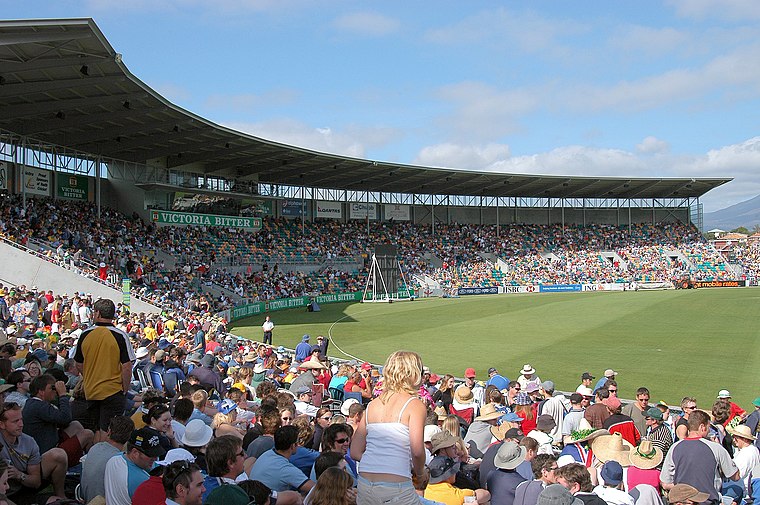 Bellerive Oval, currently known as Ninja Stadium for sponsorship reasons, is a cricket oval and Australian rules football ground located in Bellerive, a suburb on the eastern shore of Hobart, Tasmania, Australia. Bellerive Oval is situated 1¼ km south of Clarence Integrated Care Centre.
Rosny College
School
Rosny College is a government comprehensive senior secondary school located in Rosny Park, a suburb of Hobart, Tasmania, Australia. Established in 1973, the college caters for approximately 900 students in Years 11 and 12. Rosny College is situated 600 metres southwest of Clarence Integrated Care Centre.
Clarence Aquatic Centre
Sports venue
The Clarence Aquatic Centre is a major aquatic sports facility located in Montagu Bay, on the eastern shore of the state capital of Hobart, Tasmania, Australia. Clarence Aquatic Centre is situated 1 km west of Clarence Integrated Care Centre.
Places in the Area
Nearby places include Rosny Park and Bellerive.
Rosny Park
Suburb
Rosny Park is a suburb of Hobart, Tasmania, located in the City of Clarence on the eastern shore of the Derwent River. It is about five kilometres from the city centre of Hobart. Rosny Park is the commercial twin of its residential namesake, Rosny.
Bellerive
Suburb
Bellerive is a suburb of the City of Clarence, part of the greater Hobart area, Tasmania, Australia. It stretches from Kangaroo Bay, bordering Rosny Park, along the shoreline of Bellerive Esplanade to Kangaroo Bluff, then to Bellerive Beach, and east to Second Bluff where Bellerive meets Howrah.
Warrane
Suburb

Photo: Mmunji1, Public domain.
Warrane is a suburb of Hobart, Tasmania, Australia, within the City of Clarence local government area. It is approximately 5 kilometres from Hobart's CBD.
Clarence Integrated Care Centre
- Type: Office building
- Address: 16 Bayfield Street, Rosny Park, TAS 7018
- Categories: building and office
- Location: City of Clarence, Tasmania, Australia, Oceania
- View on OpenStreetMap
Latitude
-42.86643° or 42° 51′ 59″ southLongitude
147.37147° or 147° 22′ 17″ eastOpen location code
4R9949MC+CHOpenStreetMap ID
way 208505419OpenStreetMap feature
building=office
This page is based on OpenStreetMap, Wikidata, and Wikimedia Commons.
We’d love your help improving our open data sources. Thank you for contributing.
Satellite Map
Discover Clarence Integrated Care Centre from above in high-definition satellite imagery.
Notable Places Nearby
Highlights include Rosny Post Office and Village Eastlands.
Nearby Places
Explore places such as Zambrero and Gordons Hill Rd Stop 5 In.
Tasmania: Must-Visit Destinations
Delve into Hobart, Bass Strait Islands, Launceston, and Arthur-Pieman Conservation Area.
Curious Office Buildings to Discover
Uncover intriguing office buildings from every corner of the globe.
About Mapcarta. Data © OpenStreetMap contributors and available under the Open Database License". Text is available under the CC BY-SA 4.0 license, except for photos, directions, and the map. Photo: Wikimedia, CC0.