Oasi G. Salvadori
Oasi G. Salvadori is a social service facility in Municipio 6, Milan, Lombardy. Oasi G. Salvadori is situated nearby to the metro station Primaticcio, as well as near the post office Ufficio Postale Bande Nere.| Tap on a place to explore it |
Places of Interest Nearby
Highlights include San Siro and Primaticcio.
San Siro
Stadium
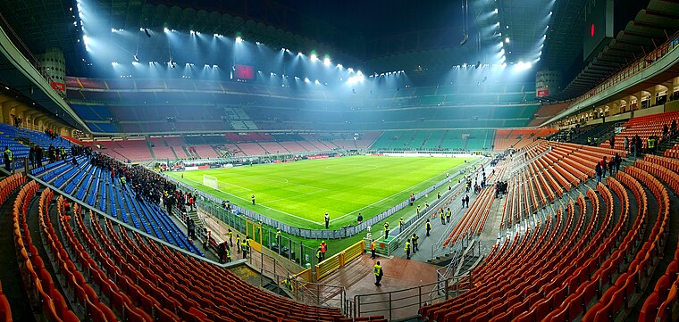
Photo: D7ckon, CC BY-SA 4.0.
San Siro is a football stadium in the San Siro district of Milan, Italy. Nicknamed La Scala del calcio, it has a seating capacity of 75,817, making it the largest stadium in Italy and one of the largest stadiums in Europe. San Siro is situated 2 km north of Oasi G. Salvadori.
Primaticcio
Metro station

Photo: Sciking, CC BY-SA 4.0.
Primaticcio is a station on Line 1 of the Milan Metro in Milan, Italy. The station is underground and is located on Via Francesco Primaticcio, within the municipal area of Milan. Primaticcio is situated 250 metres southwest of Oasi G. Salvadori.
Bande Nere
Metro station

Photo: Joaquin008, CC BY-SA 4.0.
Bande Nere is a station on Line 1 of the Milan Metro in Milan, Italy. The station is underground and is located at Piazza Giovanni dalle Bande Nere. Bande Nere is situated 450 metres east of Oasi G. Salvadori.
Places in the Area
Nearby places include Quartiere Villa Magentino and Giambellino-Lorenteggio.
Quartiere Villa Magentino
Neighborhood

Photo: Arbalete, CC BY-SA 4.0.
Quartiere Villa Magentino is a neighborhood.
Giambellino-Lorenteggio
Suburb

Photo: Wikimedia, CC BY-SA 3.0.
Giambellino and Lorenteggio are two historical and populous residential neighborhoods of Milan, Italy. Together, they form a district, part of the Zone 6 administrative division of Milan.
San Siro
Suburb

Photo: Flavmi, CC BY-SA 3.0.
San Siro is a vast district of Milan, Italy, part of the Zone 7 administrative division of the city. About 5 km north-west of the city centre, it borders the districts of Lampugnano, QT8, FieraMilano, and Trenno.
Oasi G. Salvadori
- Type: Social service facility
- Category: building
- Location: Municipio 6, Milan, Province of Milan, Grande Milano, Lombardy, Northwest Italy, Italy, Europe
- View on OpenStreetMap
Latitude
45.46149° or 45° 27′ 41″ northLongitude
9.13069° or 9° 7′ 51″ eastLevels
2Open location code
8FQFF46J+H7OpenStreetMap ID
way 547479073OpenStreetMap feature
amenity=social_facilityOpenStreetMap feature
building=yes
This page is based on OpenStreetMap, Wikidata, and Wikimedia Commons.
We’d love your help improving our open data sources. Thank you for contributing.
Satellite Map
Discover Oasi G. Salvadori from above in high-definition satellite imagery.
Notable Places Nearby
Highlights include Ufficio Postale Bande Nere and Consiglio di Zona 6.
Nearby Places
Explore places such as Scuola Media Statale Emilio De Marchi and CAV Ambrosiano.
Milan: Must-Visit Destinations
Delve into Centro Storico, Outer Milan, North Milan, and West Milan.
Curious Social Service Facilities to Discover
Uncover intriguing social service facilities from every corner of the globe.
About Mapcarta. Data © OpenStreetMap contributors and available under the Open Database License". Text is available under the CC BY-SA 4.0 license, except for photos, directions, and the map. Photo: Stefano1111, CC BY-SA 3.0.