Wallstale
Wallstale is a residential area in Stirling, Scotland. Wallstale is situated nearby to the archaeological site Wester Craigend, dun site, as well as near the peak Gillies Hill.| Tap on a place to explore it |
Places of Interest Nearby
Highlights include Gillies Hill and Stirling Castle.
Gillies Hill
Peak

Photo: Peigimccann, CC BY-SA 3.0.
Gillies Hill is located west of Stirling and the M9, south of Cambusbarron, and north of the Bannock Burn in Central Scotland. Gillies Hill covers a 140 hectares crag and tail which rises from a height of 79 metres at the Bannock Burn Bridge near Sauchie Craig to an elevation of 162 m at a point which overlooks the former quarrying operation to the west and Stirling Castle to the east.
Stirling Castle
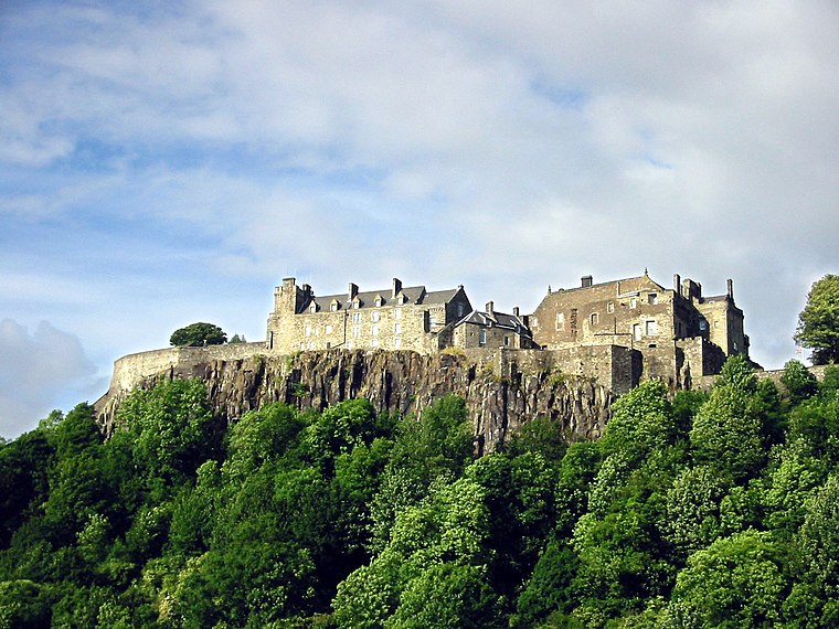
Photo: Wikimedia, CC BY-SA 3.0.
Stirling Castle, located in Stirling, is one of the largest and most historically and architecturally important castles in Scotland. The castle sits atop an intrusive crag, which forms part of the Stirling Sill geological formation. Stirling Castle is situated 2½ miles northeast of Wallstale.
Stirling railway station
Railway station

Photo: Andrew Abbott, CC BY-SA 2.0.
Stirling railway station is a railway station located in Stirling, Scotland. It is located on the former Caledonian Railway main line between Glasgow and Perth. Stirling railway station is situated 2½ miles northeast of Wallstale.
Places in the Area
Nearby places include Cambusbarron and Torbrex Village.
Cambusbarron
Village

Photo: Richard Webb, CC BY-SA 2.0.
Cambusbarron is a village in Stirling, Scotland. In the 2001 census, it had a population of 3,224. There is evidence of settlement at the site since the Bronze Age, and several forts dating from the Iron Age have been found near the village.
Torbrex Village
Suburb

Photo: Richard Webb, CC BY-SA 2.0.
Torbrex is an area in the southwest of Stirling, Scotland, which developed around a small weaving village. It is neighboured by Cambusbarron to the west, St. Ninians to the south, Livilands to the east and Kenningknowes and Laurelhill to the north.
St. Ninians
Suburb

Photo: AllyD, Public domain.
St. Ninians is a long-standing settlement which is now a district of the city of Stirling in central Scotland. It is located approximately one mile south of the city centre.
Wallstale
- Type: Residential area
- Location: Stirling, Scotland, United Kingdom, Britain and Ireland, Europe
- View on OpenStreetMap
Latitude
56.09393° or 56° 5′ 38″ northLongitude
-3.97229° or 3° 58′ 20″ westOpen location code
9C8R32VH+H3OpenStreetMap ID
way 694785035OpenStreetMap feature
landuse=residential
This page is based on OpenStreetMap, Wikidata, and Wikimedia Commons.
We’d love your help improving our open data sources. Thank you for contributing.
Satellite Map
Discover Wallstale from above in high-definition satellite imagery.
Notable Places Nearby
Highlights include Wallstale, dun site and Wester Craigend, dun site.
Nearby Places
Explore places such as Wester Craigend and Graystale.
Scotland: Must-Visit Destinations
Delve into Edinburgh, Glasgow, Aberdeen, and Dundee.
Curious Residential Areas to Discover
Uncover intriguing residential areas from every corner of the globe.
About Mapcarta. Data © OpenStreetMap contributors and available under the Open Database License". Text is available under the CC BY-SA 4.0 license, except for photos, directions, and the map. Photo: Ritchyblack, FAL.