Istanbolton Shawarma
Istanbolton Shawarma is a fast food restaurant in Bolton, England. Istanbolton Shawarma is situated nearby to the theater building The Victoria Hall, as well as near the movie theater The Light.| Tap on a place to explore it |
Places of Interest Nearby
Highlights include Bolton Art Gallery, Library & Museum and Bolton Town Hall.
Bolton Art Gallery, Library & Museum
Museum
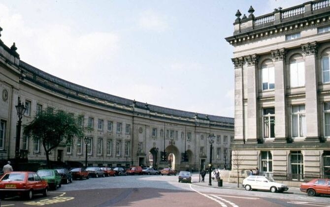
Photo: Austen Redman, CC BY-SA 2.5.
Bolton Art Gallery, Library & Museum is a public museum, art gallery, library and aquarium in the town of Bolton, England, owned by Bolton Metropolitan Borough Council. Bolton Art Gallery, Library & Museum is situated 1,000 feet south of Istanbolton Shawarma.
Bolton Town Hall
Town hall
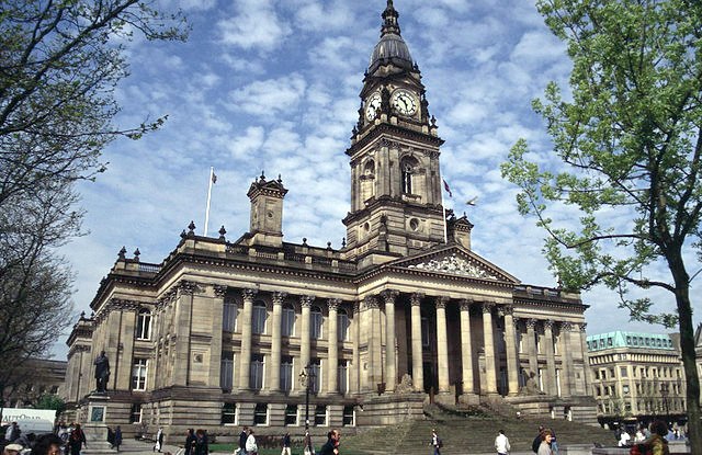
Photo: Wikimedia, CC BY-SA 2.0.
Bolton Town Hall in Victoria Square, Bolton, Greater Manchester, England, was built between 1866 and 1873 for the County Borough of Bolton to designs by William Hill of Leeds and George Woodhouse of Bolton. Bolton Town Hall is situated 730 feet south of Istanbolton Shawarma.
Octagon Theatre
Theater building
 The Octagon Theatre is a producing theatre located in Bolton, Greater Manchester, England. Octagon Theatre is situated 1,000 feet south of Istanbolton Shawarma.
Places in the Area
Nearby places include Bolton and Halliwell.
Bolton
 Bolton is a large town in Greater Manchester in the North-West of England, 17 miles north of Manchester city centre. It celebrates its industrial heritage of canals, coal, cotton, and railways.
Halliwell
Suburb

Photo: Plucas58, CC BY-SA 3.0.
Halliwell is predominantly a residential area of Bolton, Greater Manchester, England. It gives its name to an electoral ward of the wider Metropolitan Borough of Bolton. The population of this ward taken at the 2011 census was 13,929.
Deane
Suburb

Photo: Wikimedia, CC BY-SA 2.0.
Deane is an area of Bolton, in Greater Manchester, England. It is about 2 miles south west of Bolton and 11 miles northwest of Manchester. Historically a part of Lancashire, the parish of Deane was one of eleven parishes within the hundred of Salford and covered roughly half of the present Metropolitan Borough of Bolton.
Istanbolton Shawarma
- Type: Fast food restaurant
- Categories: building, food, and restaurant
- Location: Bolton, England, United Kingdom, Britain and Ireland, Europe
- View on OpenStreetMap
Latitude
53.58015° or 53° 34′ 49″ northLongitude
-2.43069° or 2° 25′ 51″ westOpen location code
9C5VHHJ9+3POpenStreetMap ID
way 733243756OpenStreetMap feature
amenity=fast_foodOpenStreetMap feature
building=yes
This page is based on OpenStreetMap, Wikidata, and Wikimedia Commons.
We’d love your help improving our open data sources. Thank you for contributing.
Satellite Map
Discover Istanbolton Shawarma from above in high-definition satellite imagery.
Notable Places Nearby
Highlights include The Victoria Hall and Bolton Post Office.
Nearby Places
Explore places such as Ozel Barber Shop and Bolton - Knowsley Street.
England: Must-Visit Destinations
Delve into London, Manchester, Sheffield, and Leeds.
Curious Fast Food Restaurants to Discover
Uncover intriguing fast food restaurants from every corner of the globe.
About Mapcarta. Data © OpenStreetMap contributors and available under the Open Database License". Text is available under the CC BY-SA 4.0 license, except for photos, directions, and the map. Photo: sidibousaid, CC BY 2.0.