Hampstead House
Hampstead House is a residential area in Corbridge, Northumberland, England. Hampstead House is situated nearby to Corbridge Middle School, as well as near Corbridge Roman Site Museum.| Tap on a place to explore it |
Places of Interest Nearby
Highlights include Coria and Aydon Castle.
Coria

Photo: Mike Quinn, CC BY-SA 2.0.
Coria was a fort and town 2.5 miles south of Hadrian's Wall, in the Roman province of Britannia. It was strategically located on the junction of a major Roman north–south road with the River Tyne and the Roman Stanegate road, which was also the first frontier line which ran east–west between Coria and Luguvalium. Coria is situated 3,000 feet south of Hampstead House.
Aydon Castle
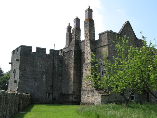
Photo: Wikimedia, CC BY-SA 2.0.
Aydon Castle, previously sometimes called Aydon Hall, is a fortified manor house at Aydon near to the town of Corbridge, Northumberland, England. It is a Scheduled Ancient Monument, and is designated by English Heritage as a Grade I listed building. Aydon Castle is situated 1¼ miles east of Hampstead House.
Corbridge Vicar’s Pele
Historic building

Photo: RHaworth, CC BY-SA 4.0.
Corbridge Vicar's Pele is a pele tower in the village of Corbridge, Northumberland, England. It was a three-storey defensive pele tower, with one room to each storey, built in the churchyard in 1318, and used as the vicarage for the adjacent church. Corbridge Vicar’s Pele is situated 1 mile southeast of Hampstead House.
Places in the Area
Nearby places include Halton and Aydon.
Halton
Hamlet

Photo: Mike Quinn, CC BY-SA 2.0.
Halton is a village and former civil parish, now in the parish of Whittington, in the southern part of Northumberland, England. It is situated 3 miles north of Corbridge just south of Hadrian's Wall. Halton is situated 1½ miles northeast of Hampstead House.
Aydon
Hamlet
Photo: Wikimedia, CC BY-SA 2.0.
Aydon is a village and former civil parish, now in the parish of Corbridge, in Northumberland, England. It is about 2 miles northeast of Corbridge on the B6321 road. Aydon is situated 1½ miles east of Hampstead House.
Anick
Hamlet

Photo: Oliver Dixon, CC BY-SA 2.0.
Anick is a village and former civil parish, now in the parish of Sandhoe, in Northumberland, England, situated to the north of Hexham. In 1881 the parish had a population of 153. Anick is situated 2 miles west of Hampstead House.
Hampstead House
Latitude
54.98642° or 54° 59′ 11″ northLongitude
-2.02846° or 2° 1′ 43″ westOpen location code
9C6VXXPC+HJOpenStreetMap ID
way 749706061OpenStreetMap feature
landuse=residential
This page is based on OpenStreetMap, Wikidata, and Wikimedia Commons.
We’d love your help improving our open data sources. Thank you for contributing.
Satellite Map
Discover Hampstead House from above in high-definition satellite imagery.
Places with the Same Name
Discover other places named “Hampstead House”.
Notable Places Nearby
Highlights include Corbridge Middle School and Corbridge Roman Site Museum.
Nearby Places
Explore places such as Shawwell Business Centre and Roman Town entrance.
Northumberland: Must-Visit Destinations
Delve into Berwick-upon-Tweed, Lindisfarne, Alnwick, and Morpeth.
Curious Residential Areas to Discover
Uncover intriguing residential areas from every corner of the globe.
About Mapcarta. Data © OpenStreetMap contributors and available under the Open Database License". Text is available under the CC BY-SA 4.0 license, except for photos, directions, and the map. Photo: RHaworth, CC BY 2.5.