Monument Bridge
Monument Bridge is a bridge in Woking District, Surrey, England. Monument Bridge is situated nearby to the archaeological site bellbarrow, as well as near disc barrow.| Tap on a place to explore it |
Places of Interest Nearby
Highlights include Shah Jahan Mosque and Saint Paul’s Church.
Shah Jahan Mosque
Mosque
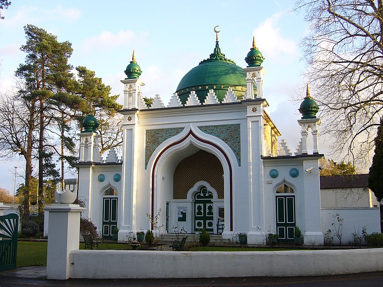
Photo: RHaworth, CC BY-SA 3.0.
The Shah Jahan Mosque on Oriental Road, Woking, England, is the first purpose-built mosque in the United Kingdom. Built in 1889, it is located 30 miles southwest of London. Shah Jahan Mosque is situated 1,800 feet south of Monument Bridge.
Saint Paul’s Church
Church

Photo: Robin Webster, CC BY-SA 2.0.
Saint Paul’s Church is situated 2,000 feet south of Monument Bridge.
Woking railway station
Railway station

Photo: Murgatroyd49, CC BY-SA 4.0.
Woking railway station is a principal commuter stop on the South West Main Line, which serves the town of Woking, in Surrey, England. It lies 24 miles 27 chains down the line from London Waterloo. Woking railway station is situated 1 mile southwest of Monument Bridge.
Places in the Area
Nearby places include Woking and Sheerwater.
Woking

Photo: Wikimedia, CC BY-SA 3.0.
Woking is the other large town in Surrey apart from Guildford. It is home to Henry VIII's Royal Palace.
Sheerwater
Suburb
Photo: Colin Smith, CC BY-SA 2.0.
Sheerwater is a residential neighbourhood or small suburb of Woking, in the Woking district in Surrey, England, occasionally described as a village, between West Byfleet and Horsell.
Horsell
Village
Horsell is a village in the borough of Woking in Surrey, England, less than a mile north-west of Woking town centre. In November 2012, its population was 9,384.
Monument Bridge
- Type: Bridge
- Category: transportation
- Location: Woking District, Surrey, South East England, England, United Kingdom, Britain and Ireland, Europe
- View on OpenStreetMap
Latitude
51.32752° or 51° 19′ 39″ northLongitude
-0.54327° or 0° 32′ 36″ westOpen location code
9C3X8FH4+2MOpenStreetMap ID
way 837272506OpenStreetMap feature
man_made=bridge
This page is based on OpenStreetMap, Wikidata, and Wikimedia Commons.
We’d love your help improving our open data sources. Thank you for contributing.
Satellite Map
Discover Monument Bridge from above in high-definition satellite imagery.
Places with the Same Name
Discover other places named “Monument Bridge”.
Notable Places Nearby
Highlights include bellbarrow and disc barrow.
Nearby Places
Explore places such as Britannia Wharf and Jewson.
Surrey: Must-Visit Destinations
Delve into Guildford, Woking, Godalming, and Epsom.
Curious Bridges to Discover
Uncover intriguing bridges from every corner of the globe.
About Mapcarta. Data © OpenStreetMap contributors and available under the Open Database License". Text is available under the CC BY-SA 4.0 license, except for photos, directions, and the map. Photo: Wikimedia, CC0.