Pagno
Pagno is a residential area in Pagno, Province of Cuneo, Piedmont. Pagno is situated nearby to the church Chiesa Parrocchiale, as well as near the village Castellar.| Tap on a place to explore it |
Places of Interest Nearby
Highlights include Saints Peter and Columbanus Abbey and Santuario di Santa Cristina.
Saints Peter and Columbanus Abbey
Church

Photo: Trebbia, CC BY-SA 3.0.
Saints Peter and Columbanus Abbey is a church, which is situated 1 km southwest of Pagno.
Santuario di Santa Cristina
Church

Photo: Betty&Giò, CC BY-SA 4.0.
Santuario di Santa Cristina is a church, which is situated 2 km south of Pagno.
Verzuolo Castle
Castle
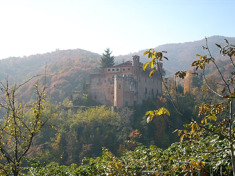 Verzuolo Castle is a medieval castle in the Piedmont region of Italy. It is located in the Province of Cuneo near Verzuolo, around 3 miles south of Saluzzo. Verzuolo Castle is situated 3½ km southeast of Pagno.
Places in the Area
Nearby places include Castellar.
Castellar
Village

Photo: F Ceragioli, CC BY-SA 3.0.
Castellar was a comune in the Province of Cuneo in the Italian region Piedmont, located about 50 kilometres southwest of Turin and about 30 kilometres northwest of Cuneo. As of 31 December 2004, it had a population of 253 and an area of 3.8 square kilometres.
Pagno
- Type: Residential area
- Location: Pagno, Province of Cuneo, Piedmont, Northwest Italy, Italy, Europe
- View on OpenStreetMap
Latitude
44.6157° or 44° 36′ 57″ northLongitude
7.4321° or 7° 25′ 56″ eastOpen location code
8FP9JC8J+7ROpenStreetMap ID
way 857882641OpenStreetMap feature
landuse=residential
This page is based on OpenStreetMap, Wikidata, and Wikimedia Commons.
We’d love your help improving our open data sources. Thank you for contributing.
Satellite Map
Discover Pagno from above in high-definition satellite imagery.
Places with the Same Name
Discover other places named “Pagno”.
Notable Places Nearby
Highlights include Municipio di Pagno and Chiesa Parrocchiale.
Nearby Places
Explore places such as Residenza Valle Bronda and Residenza Valle Bronda.
Piedmont: Must-Visit Destinations
Delve into Turin, Novara, Asti, and Alessandria.
Curious Residential Areas to Discover
Uncover intriguing residential areas from every corner of the globe.
About Mapcarta. Data © OpenStreetMap contributors and available under the Open Database License". Text is available under the CC BY-SA 4.0 license, except for photos, directions, and the map. Photo: Wikimedia, CC BY-SA 3.0.