Getliņu ezeri
Getliņu ezeri is a lake in Salaspils pagasts, Salaspils Municipality. Getliņu ezeri is situated nearby to the hamlet Dzintars, as well as near Getliņi.| Tap on a place to explore it |
Places of Interest
Highlights include Salaspils Memorial Ensemble and Rumbula Station.
Salaspils Memorial Ensemble
Museum
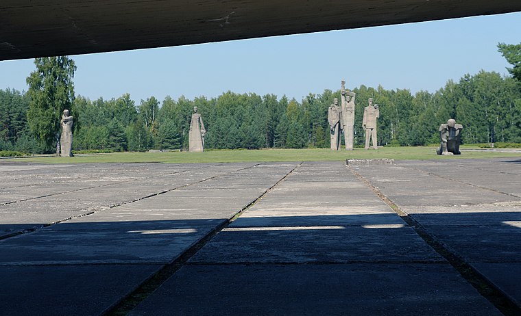
Photo: Agnete, CC BY-SA 4.0.
Salaspils Memorial Ensemble is a museum.
Rumbula Station
Railway station

Photo: Titāns, CC BY-SA 4.0.
Rumbula Station is a railway station on the Riga – Daugavpils Railway in Latvia.

Places in the Area
Nearby places include Salaspils and Salaspils.
Salaspils

Photo: Derbrauni, CC BY-SA 3.0.
The Salaspils concentration camp memorial complex is in the Riga region, about 15 km southeast of Riga and is a memorial for the people who died there during the Nazi regime in Latvia.
Salaspils
Town
 Salaspils is a town in the Vidzeme region of Latvia. It is the administrative centre of Salaspils Municipality. The town is situated on the northern bank of the Daugava river, 18 kilometers to the south-east of the city of Riga.
Rumbula
Suburb

Photo: Avi1111, CC BY-SA 3.0.
Rumbula is a neighbourhood of Riga located in the Latgale Suburb, on the right bank of the Daugava river. With a population of about 368 inhabitants in 2010, Rumbula's territory covers 6.978 km2.
Getliņu ezeri
- Type: Lake
- Category: body of water
- Location: Salaspils pagasts, Salaspils Municipality, Latvia, Baltic states, Europe
- View on OpenStreetMap
Latitude
56.8905° or 56° 53′ 26″ northLongitude
24.2921° or 24° 17′ 32″ eastOpen location code
9G86V7RR+5ROpenStreetMap ID
way 965398037OpenStreetMap feature
natural=waterOpenStreetMap feature
water=lake
This page is based on OpenStreetMap, Wikidata, and Wikimedia Commons.
We’d love your help improving our open data sources. Thank you for contributing.
Satellite Map
Discover Getliņu ezeri from above in high-definition satellite imagery.
Localities in the Area
Explore places such as Dzintars and Getliņi.
Notable Places Nearby
Highlights include Getliņu ezeri and Getliņu Ezeri.
Latvia: Must-Visit Destinations
Delve into Riga, Latgale, Daugavpils, and Jūrmala.
Curious Lakes to Discover
Uncover intriguing lakes from every corner of the globe.
About Mapcarta. Data © OpenStreetMap contributors and available under the Open Database License". Text is available under the CC BY-SA 4.0 license, except for photos, directions, and the map. Photo: Pudelek, CC BY-SA 3.0.