Unterrothorn
Unterrothorn is a peak in Aosta Valley, Northwest Italy and has an elevation of 3,103 metres. Unterrothorn is situated nearby to the locality Blauherd, as well as near Flue.| Tap on a place to explore it |
Places of Interest
Highlights include Unterrothorn and Oberrothorn.
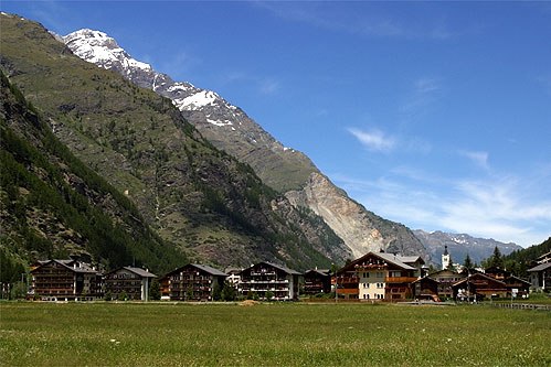
Unterrothorn
Peak

Photo: Fisheke, Public domain.
The Unterrothorn is a mountain of the Swiss Pennine Alps, overlooking Zermatt in the canton of Valais. It is located west of the Oberrothorn, on the range north of the Findel Glacier.
Oberrothorn
Peak

Photo: Whgler, CC BY-SA 3.0.
The Oberrothorn is a mountain of the Swiss Pennine Alps, overlooking Zermatt in the canton of Valais. Its summit can be easily reached via a trail on its southern flank, from the Unterrothorn cable car station or from Sunnegga.
Bösentrift
Peak
The Bösentrift is a mountain of the Pennine Alps, overlooking Täsch and Zermatt in the canton of Valais. It lies north of the Oberrothorn.
Places in the Area
Nearby places include Zermatt and Täsch.
Zermatt

Photo: Paul Asman and Jill Lenoble, CC BY 2.0.
Zermatt is one of the most famous mountain resorts in Switzerland, and attracts people from around the world. Located in the German-speaking part of Valais, its most popular sight is the iconic Matterhorn, one of Switzerland's most famous mountains.
Täsch
Village
 Täsch is a municipality in the district of Visp in the canton of Valais in Switzerland. It is located about 5 km north of Zermatt. The local language is Swiss German.

Unterrothorn
- Type: Peak with an elevation of 3,103 metres
- Category: landform
- Location: Aosta Valley, Northwest Italy, Italy, Europe
- View on OpenStreetMap
Latitude
46.0208° or 46° 1′ 15″ northLongitude
7.7975° or 7° 47′ 51″ eastElevation
3,103 metres (10,180 feet)Open location code
8FR92QCX+82OpenStreetMap ID
node 11537289295OpenStreetMap feature
natural=peak
This page is based on OpenStreetMap, Wikidata, and Wikimedia Commons.
We’d love your help improving our open data sources. Thank you for contributing.
Satellite Map
Discover Unterrothorn from above in high-definition satellite imagery.
In Other Languages
“Unterrothorn” goes by many names.
- German: “Unterrothorn”
Places with the Same Name
Discover other places named “Unterrothorn”.
Localities in the Area
Explore places such as Blauherd and Flue.
Notable Places Nearby
Highlights include Foto-Spot Rothorn and Furggji.
Aosta Valley: Must-Visit Destinations
Delve into Aosta, Courmayeur, and La Thuile.
Curious Peaks to Discover
Uncover intriguing peaks from every corner of the globe.
About Mapcarta. Data © OpenStreetMap contributors and available under the Open Database License". Text is available under the CC BY-SA 4.0 license, except for photos, directions, and the map. Photo: Cruccone, CC BY 3.0.