Sforza-Policlinico
Sforza-Policlinico is a metro station in Centro Storico, Milan, Lombardy. Sforza-Policlinico is situated nearby to the university Dipartimento di studi storici, Università degli studi di Milano, as well as near the garden Cortile Legnaia.| Tap on a place to explore it |
Photo: Protostellare, CC BY-SA 4.0.
Places of Interest Nearby
Highlights include San Nazaro in Brolo and Teatro Carcano.
San Nazaro in Brolo
Church

Photo: Paolobon140, CC BY-SA 4.0.
The basilica of San Nazaro in Brolo or San Nazaro Maggiore is a 4th-century Roman Catholic church located in Piazza San Nazzaro in Brolo in Milan, region of Lombardy, Italy. San Nazaro in Brolo is situated 120 metres west of Sforza-Policlinico.
Teatro Carcano
Theater building
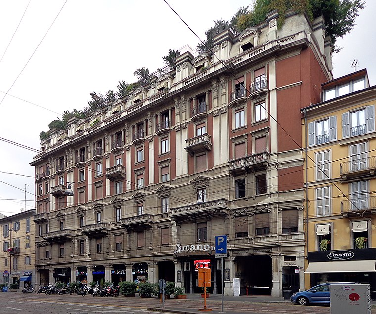
Photo: Arbalete, CC BY-SA 4.0.
The Teatro Carcano is a theatre in Milan, Italy, located at 63 Corso di Porta Romana. Although now exclusively devoted to plays and dance, it served as an opera house for much of the 19th century and saw the premieres of several important operas. Teatro Carcano is situated 240 metres southeast of Sforza-Policlinico.
Biblioteca Ambrosiana
Library

Photo: Paolobon140, CC BY-SA 4.0.
The Biblioteca Ambrosiana is a historic library in Milan, Italy, also housing the Pinacoteca Ambrosiana, the Ambrosian art gallery. Named after Ambrose, the patron saint of Milan, it was founded in 1609 by Cardinal Federico Borromeo, whose agents scoured Western Europe and even Greece and Syria for books and manuscripts. Biblioteca Ambrosiana is situated 1 km northwest of Sforza-Policlinico.
Places in the Area
Nearby places include South Milan and Bottonuto.
South Milan

Photo: Guilhem Vellut, CC BY 2.0.
Southern Milan is chiefly a residential part of Milan. While you can find a couple of old landmarks in here, there aren't as much of them as in the Centro Storico, and this part of the city is more "local" and "ordinary".
Bottonuto
Locality

Photo: Wikimedia, Public domain.
The Bottonuto was an ancient district of Milan, Italy, located near the center of the city. Dating back to Roman times, in the late 19th the district had become a place of ill repute, brothels and open-air outhouses.

Sforza-Policlinico
- Type: Metro station
- Description: Milan Metro station
- Categories: underground station, railway station, station, and transportation
- Location: Centro Storico, Milan, Province of Milan, Grande Milano, Lombardy, Northwest Italy, Italy, Europe
- View on OpenStreetMap
Latitude
45.45862° or 45° 27′ 31″ northLongitude
9.19429° or 9° 11′ 40″ eastInception
October 12th, 2024Operator
ATMNetwork
STIBMOpen location code
8FQFF55V+CPOpenStreetMap ID
node 11638913897OpenStreetMap feature
public_transport=stationOpenStreetMap feature
railway=stationWikidata ID
Q23016268
This page is based on OpenStreetMap, Wikidata, and Wikimedia Commons.
We’d love your help improving our open data sources. Thank you for contributing.
Satellite Map
Discover Sforza-Policlinico from above in high-definition satellite imagery.
In Other Languages
From Dutch to Lombard—“Sforza-Policlinico” goes by many names.
- Dutch: “Sforza-Policlinico”
- French: “Sforza-Policlinico”
- German: “U-Bahnhof Sforza Policlinico”
- Hungarian: “Sforza-Policlinico”
- Italian: “Sforza-Policlinico”
- Korean: “스포르차-폴리클리니코역”
- Lombard: “Sforza Policlinich”
- Lombard: “Sforza-Policlinich”
Notable Places Nearby
Highlights include Dipartimento di studi storici, Università degli studi di Milano and Cortile Legnaia.
Nearby Places
Explore places such as Sforza-Policlinico and Parcheggio sotterraneo Statale.
Milan: Must-Visit Destinations
Delve into Outer Milan, North Milan, West Milan, and South Milan.
Curious Metro Stations to Discover
Uncover intriguing metro stations from every corner of the globe.
About Mapcarta. Data © OpenStreetMap contributors and available under the Open Database License". Text is available under the CC BY-SA 4.0 license, except for photos, directions, and the map. Photo: Protostellare, CC BY-SA 4.0.