Napoleone III
Napoleone III is a tram stop in Municipio Roma I, Rome, Lazio. Napoleone III is situated nearby to the college Pontificio Istituto di Archeologia Cristiana, as well as near Pontifical Oriental Institut.| Tap on a place to explore it |
Places of Interest Nearby
Highlights include Santa Maria Maggiore and Roma Termini railway station.
Santa Maria Maggiore
Church
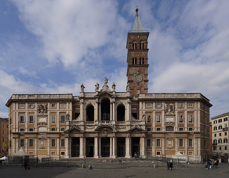
Photo: NikonZ7II, CC BY-SA 4.0.
Santa Maria Maggiore, also known as the Basilica of Saint Mary Major or the Basilica of Saint Mary the Great, is one of the four major papal basilicas and one of the Seven Pilgrim Churches of Rome. Santa Maria Maggiore is situated 150 metres west of Napoleone III.
Roma Termini railway station
Railway station

Photo: Ingolf, CC BY-SA 2.0.
Roma Termini is the main railway station of Rome, Italy. It is named after the district of the same name, which in turn took its name from ancient Baths of Diocletian, which lies across the street from the main entrance. Roma Termini railway station is situated 390 metres north of Napoleone III.
Santa Prassede
Church
 The Basilica of Saint Praxedes, commonly known in Italian as Santa Prassede, is an early medieval titular church and minor basilica located near the papal basilica of Saint Mary Major, on Via di Santa Prassede, rione Monti in Rome, Italy. Santa Prassede is situated 220 metres southwest of Napoleone III.
Places in the Area
Nearby places include Esquilino-San Giovanni and Viminal Hill.
Esquilino-San Giovanni

Photo: Cristian Bortes, CC BY 2.0.
Esquilino and San Giovanni are adjacent neighborhoods in Rome. Esquilino is named for the Esquiline hill on which it stands. It lies south of the Termini station and is centred more or less on the Piazza Vittorio Emmanuele II.
Viminal Hill
Locality
 The Viminal Hill is the smallest of the famous Seven Hills of Rome. A finger-shape cusp pointing toward central Rome between the Quirinal Hill to the northwest and the Esquiline Hill to the southeast, it is home to the Teatro dell'Opera and the Termini Railway Station.
Modern Centre

Photo: Goldmund100, CC BY-SA 3.0.
The Modern Centre of Rome, home to the Via Veneto, Quirinale, Castro Pretorio, Repubblica, and Trevi neighbourhoods, is the city's hub of activity, especially shopping and nightlife.
Napoleone III
- Type: Tram stop
- Categories: railway stop, transport stop, bus stop, and transportation
- Location: Municipio Roma I, Rome, Metropolitan Rome, Lazio, Central Italy, Italy, Europe
- View on OpenStreetMap
Latitude
41.89789° or 41° 53′ 52″ northLongitude
12.50025° or 12° 30′ 1″ eastOpen location code
8FHJVGX2+53OpenStreetMap ID
node 12712773651OpenStreetMap feature
highway=bus_stopOpenStreetMap feature
public_transport=stop_positionOpenStreetMap feature
railway=tram_stop
This page is based on OpenStreetMap, Wikidata, and Wikimedia Commons.
We’d love your help improving our open data sources. Thank you for contributing.
Satellite Map
Discover Napoleone III from above in high-definition satellite imagery.
Notable Places Nearby
Highlights include Pontificio Istituto di Archeologia Cristiana and Pontifical Oriental Institut.
Nearby Places
Explore places such as Napoleone III and Monte dei Paschi di Siena.
Rome: Must-Visit Destinations
Delve into North Centre, Modern Centre, Old Rome, and Vatican.
Curious Tram Stops to Discover
Uncover intriguing tram stops from every corner of the globe.
About Mapcarta. Data © OpenStreetMap contributors and available under the Open Database License". Text is available under the CC BY-SA 4.0 license, except for photos, directions, and the map. Photo: Absent-08, CC BY-SA 4.0.