Barrel of Butter lighthouse
Barrel of Butter lighthouse is a lighthouse in Orkney Islands, Scotland. Barrel of Butter lighthouse is situated nearby to the island Cava, as well as near the locality Hangaback.| Tap on a place to explore it |
Photo: George Brown, CC BY-SA 2.0.
- Type: Lighthouse
- Description: lighthouse in Orkney Islands, Scotland, UK
- Also known as: “Barrel of Butter”
Places of Interest Nearby
Highlights include Barrel of Butter and SMS Cöln.
Barrel of Butter
Islet

Photo: George Brown, CC BY-SA 2.0.
The Barrel of Butter, formerly known as Carlin Skerry, is a skerry in Scapa Flow in the Orkney Islands.
SMS Cöln

Photo: Wikimedia, Public domain.
SMS Cöln was a light cruiser in the German Kaiserliche Marine, the second to bear this name, after her predecessor SMS Cöln had been lost in the Battle of Heligoland Bight. SMS Cöln is situated 1 mile northwest of Barrel of Butter lighthouse.
SMS Kronprinz
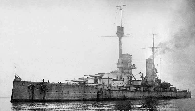
Photo: Wikimedia, Public domain.
SMS Kronprinz was the last dreadnought battleship of the four-ship König class of the German Imperial Navy. The battleship was laid down in November 1911 and launched on 21 February 1914. SMS Kronprinz is situated 1¼ miles west of Barrel of Butter lighthouse.
Places in the Area
Nearby places include Hangaback and Houton.
Hangaback
Locality

Photo: David Wyatt, CC BY-SA 2.0.
Hangaback is a locality, which is situated 2 miles north of Barrel of Butter lighthouse.
Houton
Village

Photo: Wikimedia, CC BY-SA 2.0.
Houton is a settlement 5 miles southeast of Stromness on the island of Mainland, Orkney, Scotland. The settlement is within the parish of Orphir, and is situated on a minor road off the A964. Houton is situated 3 miles northwest of Barrel of Butter lighthouse.
Orphir
Village

Photo: Ian Balcombe, CC BY-SA 2.0.
Orphir is a parish and settlement on Mainland, Orkney, Scotland. It is approximately 9 miles southwest of Kirkwall, and comprises a seaboard tract of about 7 by 3+1⁄2 mi, and includes Cava and the Holm of Houton. Orphir is situated 3 miles north of Barrel of Butter lighthouse.
Barrel of Butter lighthouse
- Categories: tourist attraction and tourism
- Location: Orkney Islands, Scotland, United Kingdom, Britain and Ireland, Europe
- View on OpenStreetMap
Latitude
58.89042° or 58° 53′ 26″ northLongitude
-3.12642° or 3° 7′ 35″ westOpen location code
9CCRVVRF+5COpenStreetMap ID
node 1329027332OpenStreetMap feature
man_made=lighthouseWikidata ID
Q28869310
This page is based on OpenStreetMap, Wikidata, and Wikimedia Commons.
We’d love your help improving our open data sources. Thank you for contributing.
Satellite Map
Discover Barrel of Butter lighthouse from above in high-definition satellite imagery.
In Other Languages
“Barrel of Butter lighthouse” goes by many names.
- French: “phare de Barrel of Butter”
- French: “Phare de Barrel of Butter”
Notable Places Nearby
Highlights include SMS Brummer and SMS Markgraf.
Nearby Places
Explore places such as WW1 military building and Gyre.
Orkney Islands: Must-Visit Destinations
Delve into Kirkwall, Stromness, Hoy, and Shapinsay.
Curious Lighthouses to Discover
Uncover intriguing lighthouses from every corner of the globe.
About Mapcarta. Data © OpenStreetMap contributors and available under the Open Database License". Text is available under the CC BY-SA 4.0 license, except for photos, directions, and the map. Photo: George Brown, CC BY-SA 2.0.